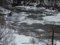
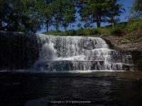
Waterfall Name: Talcottville Falls
Aka: Sugar River Falls
Location: Leyden Twn
First Visit: 01-19-2013
State: New York State
Region: Northern Region
County: Lewis County
Park Area: ————-
NYS Tourism Region: Adirondack Mountains
NYDEC Region: Western Adirondacks/Eastern Lake Ontario
Waterfall Challenge: ————-
Waterfall Location: N43.53802 W75.36616
Parking: N43.53637 W75.36700
Trailhead: ————-
Trail Name, Reference to: ————-
Stream, River: Sugar River
Height, Type: 60ft,Curtain Cascade
Elevation: 1100 ft
Level of Difficulty, Hiking Distance: Roadside view
Whitewater Rte, Canoe Rte Map: ————-
Maps: ————-
My Resource: I Love New York, Adirondacks Tug Hill Region Lewis County Visitor’s Guide
Book Resource: Waterfalls of New York State Paperback – August 9, 2012, by Scott Ensminger, David Schryver, Edward Smathers,North Country Region,pg162
Brochures, Travel Guides, Visitor Guides: I Love New York, Adirondacks Tug Hill Region Lewis County Visitor’s Guide
Trail_URL: ————-
Additional Information: http://www.adirondackstughill.com/index.php/site/attractions/waterfalls
Photos, Information Contributed to other Websites: Dig the Falls, Northern New York Waterfalls
Landmark: There are 3-4 waterfalls here.
Nearest Intersection: Hwy 12D and Cheesefactory Rd
Directions: From the intersection of Hwy 46 (highway 46 changes to highway 12d) and Hwy 294 in Boonville, take Hwy 12D north for approximately 4.1 miles. The falls will be on your left.
Comments, Notes: We took picture from Highway 12D bridge as well as we were able to get pictures from Cheesefactory Road. Just before the railings on the left hand side of the road (heading north), you will see a driveway that leads to a home. Just as you pull in immediately turn right and drive down into the parking area for the falls. You would need a high clearance vehicle to get down in there, or just park up on the highway.
————-


Pingback: Waterfalls of New York State 100+ Challenge, Dig the Falls, part 5, The North Country Region - Bobbieswaterfalls