
Waterfall Name: Jenny Creek Lower Falls
Aka: Jayville Rapid/Slide, Jenny Creek Falls, High Falls
Location: Pitcairn Twn
First Visit: 10-07-2010
State: New York State
Region: Northern Region
County: St. Lawrence County
Park Area: ————-
NYS Tourism Region: Thousand Island-Seaway
NYDEC Region: Western Adirondacks/Eastern Lake Ontario
Waterfall Challenge: ————-
Waterfall Location: N44.18069 W75.25677
Parking: N44.18127 W75.25605
Trailhead: ————-
Trail Name, Reference to: ————-
Stream, River: Jenny Creek
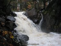
Height, Type: 10ft,Slide,Class 5.0 Rapids
Elevation: 912 ft
Level of Difficulty, Hiking Distance: ————-
Whitewater Rte, Canoe Rte Map: https://www.americanwhitewater.org/content/River/detail/id/4249/
Maps: ————-
My Resource: https://www.americanwhitewater.org/content/River/detail/id/4249/
Book Resource: ————-
Brochures, Travel Guides, Visitor Guides: ————-
Trail_URL: ————-
Additional Information: Putting together this whole section of Jenny Creek was and still is a bit confusing so I will piece it together as best as possible. When I checked this location out back in 2010, I had only 2 locations with the coordinates for. And those I had gotten from the World Waterfall database. Since then I have gain more knowledge along with better technology. I recently found that the American Whitewater has a page on this section of Jenny Creek. By matching my photos up with theirs along with similar descriptions, I have been able to make some corrections. The whitewater route starts at Powell Road, south of Hwy 3. When I was there you could not drive on Jayville road all the way, as you come to where the bridge is out. So I did not check out their first 1.3 miles of the route.
Photos, Information Contributed to other Websites: Dig the Falls, Northern New York Waterfalls
Landmark: ————-
Nearest Intersection: Hwy 3 and Jayville Rd
Directions: From I-81 N in Theresa, Take exit 49 to the right onto Rt-411 towards Theresa/Lafargeville for .3 miles. Turn right onto Hwy 411 and drive for 4.7 miles. Turn left onto Commercial St and drive for .7 miles. Turn left onto Oxbow Rd and drive for 9.6 miles. Turn right onto Cr-25 and drive for 8.8 miles. Turn left onto W Main St and drive for .3 miles. Turn right onto William St and drive for 6.1 miles. Turn right onto Hwy 812 and drive for 9.5 miles. Turn left onto Pitcairn-Fowler Rd and drive for 1.3 miles. Turn left onto Hwy 3 and drive for 1.3 miles. Bear right onto Jayville Rd and drive for 1.0 miles. The first falls is Jenny Creek Falls Lower. I have not been to this one yet. Continue on Jayville Rd for 1.0 miles. This next one is Jenny Creek Falls. Continue on Jayville Rd and drive for .6 miles to Jenny Creek Middle Falls. Continue on Jayville Rd and drive for .2 miles, this brings you to the last one, Jenny Creek Upper Falls.
Comments, Notes: And this one I had called Jenny Creek Lower Falls, and again it falls within the location and photo match with what they called Jayville Rapid Class 5.0/Jayville Slide. This may also be known as Jenny Creek Falls. This is a roadside view.
————-
————-