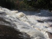
Waterfall Name: Lampsons Falls – Tooley Pond Road Waterfalls
Aka: Tooley Pond Road Waterfalls
Location: Clare Twn
First Visit: 10-07-2010
State: New York State
Region: Northern Region
County: St. Lawrence County
Park Area: Grasse River Wild Forest
NYS Tourism Region: Thousand Island-Seaway
NYDEC Region: Western Adirondacks/Eastern Lake Ontario
Waterfall Challenge: Adirondack Fifty Falls Challenge: A Guide to the Fifty Falls, by John Haywood, Russell Dunn,St. Lawrence,pg86
Waterfall Location: N44.40564 W75.07209
Parking: N44.40520 W75.06153
Trailhead: ————-
Trail Name, Reference to: There is a trail sign for the falls.
Stream, River: South Branch Grasse River
Height, Type: 40ft to 60ft
Elevation: 775 ft
Level of Difficulty, Hiking Distance: 1.2 Mile Round trip
Whitewater Rte, Canoe Rte Map: ————-
Maps: Adk Park Map Saranac P. Smith
My Resource: Eastern New York all outdoors Atlas and Field Guide Publication 2008,E6,pg91
Book Resource: Discover the Northwestern Adirondacks, Four-Season Guide to the Oswegatchie Wilderness, 3rd Edition 2007, Barbara McMartin & Bill Ingersoll 255-256 157-Lampson Falls
Brochures, Travel Guides, Visitor Guides: Adirondack Great Walks & Day Hikes A Guide to paths less taken in the Northeast’s last great wilderness.
Trail_URL: ————-
Additional Information: Waterfalls of New York State Paperback – August 9, 2012, by Scott Ensminger, David Schryver, Edward Smathers,North Country Region,pg206
Photos, Information Contributed to other Websites: ————-
Landmark: ————-
Nearest Intersection: Clare Rd Rte 27 and White Rd
Directions: From I-81 N in Theresa, Take exit 49 to the right onto Rt-411 towards Theresa/Lafargeville for .3 miles. Turn right onto Hwy 411 and drive for 4.7 miles. Turn left onto Commercial St and drive for .7 miles. Turn left onto Oxbow Rd and drive for 9.6 miles. Turn right onto Cr-25 and drive for 8.8 miles. Turn left onto W Main St and drive for .3 miles. Turn right onto William St and drive for 6.1 miles. Turn right onto Hwy 812 and drive for 9.5 miles. Turn left onto Pitcairn-Fowler Rd and drive for 1.3 miles. Turn left onto Hwy 3 and drive for 1.3 miles. Bear right onto Jayville Rd and drive for 1.0 miles. The first falls is Jenny Creek Falls Lower. I have not been to this one yet. Continue on Jayville Rd for 1.0 miles. This next one is Jenny Creek Falls. Continue on Jayville Rd and drive for .6 miles to Jenny Creek Middle Falls. Continue on Jayville Rd and drive for .2 miles, this brings you to the last one, Jenny Creek Upper Falls.
Comments, Notes: ————-
————-
————-


