
Waterfall Name: Swimming Hole falls
Aka: Rain Falls, The Cascades of 7th, 8th & 9th Falls
Location: Burns Twn
First Visit: 08-10-2013
State: New York State
Region: Western Region
County: Allegany County
Park Area: ————-
NYS Tourism Region: Chautauqua-Alleghany
NYDEC Region: Western New York
Waterfall Challenge: ————-
Waterfall Location: N42.468421 W77.740236
Parking: N42.4643 W77.73334
Trailhead: ————-
Trail Name, Reference to: ————-
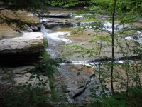
Stream, River: Canaserga Creek
Height, Type: 5ft
Elevation: ————-
Level of Difficulty, Hiking Distance: Short
Whitewater Rte, Canoe Rte Map: http://www.americanwhitewater.org/content/River/detail/id/1270
Maps: Western New York all outdoors Atlas & Field Guide Publication 2008
My Resource: http://www.americanwhitewater.org/content/River/detail/id/1270
Book Resource: ————-
Brochures, Travel Guides, Visitor Guides: Sun Valley Campsite
Trail_URL: ————-
Additional Information: ————-
Photos, Information Contributed to other Websites: Dig the Falls
Landmark: Private Campground
Nearest Intersection: Perry Rd and Hess and 70a-70
Directions: From I-90 W in Henrietta, Take exit 46 to the right onto I-390 towards Rochester/Corning and drive for .4 miles. Take the I-390 S ramp to the right towards Corning and drive for 42.8 miles. Take exit 4 to the right onto Rt-36 towards Dansville/Hornell and drive for .4 miles. Turn right onto Hornell Rd and drive for 6. miles. Turn right onto Hwy 70 and drive for 1 miles. Turn right onto Poags Hole Rd and drive for .4 miles. Turn right onto Rd for 331 ft.
Comments, Notes: ————-
————-
————-
————-