
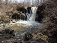
Waterfall Name: Akron Park Dam
Aka: ————-
Location: Akron
First Visit: 04-13-2014
State: New York State
Region: Western Region
County: Erie County
Park Area: Akron Falls Park
NYS Tourism Region: Niagara Frontier
NYDEC Region: Western New York
Waterfall Challenge: ————-
Waterfall Location: N43.01612 W78.49518
Parking: N43.01508 W78.48498
Trailhead: N43.01527 W78.48502
Trail Name, Reference to: ————-
Stream, River: Murder Creek
Height, Type: 10ft,Dam and Falls
Elevation: 684 ft
Level of Difficulty, Hiking Distance: approx .6 mile 1-way from parking up by Lower and Upper Falls
Whitewater Rte, Canoe Rte Map: ————-
Maps: Western New York All-Outdoors Atlas & Field Guide, 2008,B1,pg126
My Resource: Western New York All-Outdoors Atlas & Field Guide, 2008,B1,pg126
Book Resource: 200 Waterfalls in Central and Western New York: A Finder’s Guide Paperback – June 5, 2018, by Rich and Sue Freeman,Waterfalls in Niagara, Erie, Orleans, Genesee & Wyoming Counties,pg48
Brochures, Travel Guides, Visitor Guides: ————-
Trail_URL: ————-
Additional Information: Erie County Dept. of Parks, Recreation and Forestry
Photos, Information Contributed to other Websites: Dig the Falls
Landmark: ————-
Nearest Intersection: Park Skyline Drive and Stone Ridge Lane
Directions: From I-90 W in Pembroke, Take exit 48A to the right onto Rt-77 towards Pembroke/Medina and drive for 1 miles. Turn right onto Alleghany Rd and drive for .7 miles. Turn right onto Hwy 5 and drive for 3.7 miles. Turn right onto Crittenden Rd and drive for .9 miles. Turn left onto E Skyline Drive and drive for .3 miles. Keep right onto Rd and drive for .2 miles.
Comments, Notes: I have included various photos along most of the park.
————-
————-
————-