
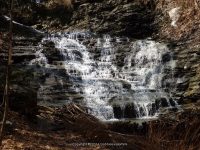
Waterfall Name: Emery Park Falls
Aka: ————-
Location: Aurora Twn
First Visit: 04-13-2014
State: New York State
Region: Western Region
County: Erie County
Park Area: Emery County Park North End
NYS Tourism Region: Niagara Frontier
NYDEC Region: Western New York
Waterfall Challenge: ————-
Waterfall Location: N42.71616 W78.59382
Parking: N42.71609 W78.59409
Trailhead: N42.71609 W78.59409
Trail Name, Reference to: ————-
Stream, River: Unnamed Stream
Height, Type: 25ft
Elevation: 1050 ft
Level of Difficulty, Hiking Distance: Short
Whitewater Rte, Canoe Rte Map: ————-
Maps: Western New York All-Outdoors Atlas & Field Guide, 2008,B6,pg111
My Resource: 200 Waterfalls in Central and Western New York: A Finder’s Guide Paperback – June 5, 2018, by Rich and Sue Freeman,Waterfalls in Niagara, Erie, Orleans, Genesee & Wyoming Counties,pg59
Book Resource: ————-
Brochures, Travel Guides, Visitor Guides: Erie County Dept. of Parks, Recreation and Forestry, http://www2.erie.gov/parks/index.php?q=emery-park
Trail_URL: ————-
Additional Information: Erie County Dept. of Parks, Recreation and Forestry
Photos, Information Contributed to other Websites: Dig the Falls
Landmark: Cilvilian Conservation Corp Stonework Remains From 1930
Nearest Intersection: Emery Rd and Cornwall Rd
Directions: From I-90 W, Take exit 49 to the right onto Rt-78 towards Depew/Lockport and drive for .9 miles. Turn right onto Transit Rd and drive for 7.8 miles. Take the Rt-400 S ramp to the right and drive for 12.8 miles. Turn right onto Emery Rd and drive for 1.1 miles. Turn right onto Rd and drive for .1 miles. Turn left onto Rd for 136 ft.
Comments, Notes: Go to the second entry to the north end and follow the road to the right. I have included pictures of location landmarks.
————-
————-
————-