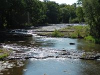
Waterfall Name: Honeoye Creek, the Ledges of, Martin Rd Ledges
Aka: ————-
Location: Lima Twn
First Visit: 08-12-2013
State: New York State
Region: Western Region
County: Livingston County
Park Area: ————-
NYS Tourism Region: Finger Lakes-Wine Country
NYDEC Region: Western Finger Lakes
Waterfall Challenge: ————-
Waterfall Location: N42.93800 W77.57462
Parking: N42.93813 W77.57566
Trailhead: ————-
Trail Name, Reference to: ————-
Stream, River: Honeoye Creek
Height, Type: 2ft drops series of ledges,5 ledges
Elevation: 696 ft
Level of Difficulty, Hiking Distance: Roadside view
Whitewater Rte, Canoe Rte Map: ————-
Maps: ————-
My Resource: 200 Waterfalls in Central and Western New York: A Finder’s Guide Paperback – June 5, 2018, by Rich and Sue Freeman,Waterfalls in Monroe, Livingston and Ontario Counties,pg110
Book Resource: ————-
Brochures, Travel Guides, Visitor Guides: ————-
Trail_URL: ————-
Additional Information: ————-
Photos, Information Contributed to other Websites: ————-
Landmark: ————-
Nearest Intersection: Marton Rd and Rte 65
Directions: From I-90 W in Henrietta, Take exit 46 to the right onto I-390 towards Rochester/Corning and drive for .4 miles. Take the I-390 S ramp to the right towards Corning and drive for 3.1 miles. Take exit 11 to the right onto Rt-15 towards Rt-251/Rush/Scottsville and drive for .3 miles. Take ramp to the left towards Rt-251 W for 207 ft. Turn left onto W Henrietta Rd and drive for .3 miles. Turn left onto Rush Scottsville Rd and drive for 1.3 miles. Turn right onto E Henrietta Rd and drive for .3 miles. Bear left onto Rush Lima Rd and drive for 3 miles. Turn left onto Monroe St and drive for 1.7 miles. Turn right onto Ontario St and drive for 1.3 miles. Turn right onto Martin Rd and drive for .1 miles.
Comments, Notes: ————-
————-
————-
————-