

Waterfall Name: Rochester High Falls
Aka: Main Falls, Upper Falls, High Falls of the Genesee River
Location: Rochester
First Visit: 04-17-2009
State: New York State
Region: Western Region
County: Monroe County
Park Area: ————-
NYS Tourism Region: Finger Lakes-Wine Country
NYDEC Region: Western Finger Lakes
Waterfall Challenge: Finger Lakes Region Waterfall Challenge Paperback – October 30, 2019, by John Haywood, Julie Hughes Romano, Bella Romano, Edward Smathers,Monroe,pg24
Waterfall Location: N43.16133 W77.61338
Parking: N43.159614 W77.617944
Trailhead: ————-
Trail Name, Reference to: ————-
Stream, River: Genesee River
Height, Type: 96ft,Free Fall
Elevation: 425 ft
Level of Difficulty, Hiking Distance: .8 Mile Round Trip
Whitewater Rte, Canoe Rte Map: ————-
Maps: Western New York All-Outdoors Atlas & Field Guide, 2008,E5,pg143
My Resource: Western New York All-Outdoors Atlas & Field Guide, 2008,E5,pg143
Book Resource: 200 Waterfalls in Central and Western New York: A Finder’s Guide Paperback – June 5, 2018, by Rich and Sue Freeman,Waterfalls in Monroe, Livingston and Ontario Counties,pg122
Brochures, Travel Guides, Visitor Guides: ————-
Trail_URL: ————-
Additional Information: Waterfalls of New York State Paperback – August 9, 2012, by Scott Ensminger, David Schryver, Edward Smathers,Finger Lakes Region ,pg126
Photos, Information Contributed to other Websites: ————-
Landmark: High Falls Garage
Nearest Intersection: Browns Race and Commercial Street
Directions: From I-90 W in Henrietta, Take exit 46 to the right onto I-390 towards Rochester/Corning and drive for .4 miles. Take the I-390 N ramp to the left towards Rochester and drive for .5 miles. Take the I-390 N ramp to the left towards Rochester and drive for 4.7 miles. Keep left onto I-390 N towards Airport/Greece and drive for .9 miles. Take exit 16 to the right onto Rt-15a/E Henrietta Rd towards Rt-15/W Henrietta Rd and drive for .2 miles. Turn right onto E Henrietta Rd and drive for .9 miles. Bear right onto Mt Hope Ave and drive for 1.4 miles. Turn left onto Ford St. and drive for .1 miles. Keep right onto Rd and drive for 1.3 miles.
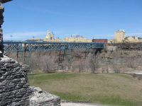
Comments, Notes: Ponte de rennes pedestrian bridge is the best spot for viewing.
————-
————-
————-
