
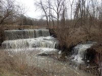
Waterfall Name: Mill Pond Falls
Aka: Otto Dam And Falls
Location: Royalton Twn
First Visit: 04-12-2014
State: New York State
Region: Western Region
County: Niagara County
Park Area: ————-
NYS Tourism Region: Niagara Frontier
NYDEC Region: Western New York
Waterfall Challenge: ————-
Waterfall Location: N43.20805 W78.56527
Parking: N43.20846 W78.56529
Trailhead: N43.20846 W78.56529
Trail Name, Reference to: ————-
Stream, River: East Branch Eighteen Mile Creek
Height, Type: 12ft,Dam And Falls
Elevation: 446 ft
Level of Difficulty, Hiking Distance: Roadside view
Whitewater Rte, Canoe Rte Map: ————-
Maps: Western New York All-Outdoors Atlas & Field Guide, 2008,C1,pg140
My Resource: Western New York All-Outdoors Atlas & Field Guide, 2008,C1,pg140
Book Resource: 200 Waterfalls in Central and Western New York: A Finder’s Guide Paperback – June 5, 2018, by Rich and Sue Freeman,Waterfalls in Niagara, Erie, Orleans, Genesee & Wyoming Counties,pg38
Brochures, Travel Guides, Visitor Guides: ————-
Trail_URL: ————-
Additional Information: World Waterfall Database
Photos, Information Contributed to other Websites: ————-
Landmark: Below Mill Pond, Historic Mill Site, Niagara Cnty Fed Of Cnsrvtn Clubs Dam N43.20779 W78.56556
Nearest Intersection: Slayton Settlement Rd and Quaker Rd
Directions: From I-90 W, Take exit 49 to the right onto Rt-78 towards Depew/Lockport and drive for .9 miles. Turn left onto Transit Rd and drive for 12.8 miles. Turn right onto Robinson Rd and drive for 4.4 miles. Turn right onto Akron Rd and drive for 1.6 miles. Keep left onto Bunker Hill Rd and drive for .3 miles. Turn left onto Gasport Rd and drive for 5.1 miles. Turn right onto Slayton Settlement Rd and drive for .6 miles. Turn left onto Quaker Rd for 91 ft.
Comments, Notes: The Historical Mabeemills Gristmill is just down the road from this.
————-
————-
————-