

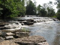
Waterfall Name: Double Drop Falls (Flint Creek)
Aka: Ontario Pathways Falls, Flint Creek Falls, Phelps Rapids
Location: Phelps Twn
First Visit: 08-04-2012
State: New York State
Region: Western Region
County: Ontario County
Park Area: ————-
NYS Tourism Region: Finger Lakes-Wine Country
NYDEC Region: Western Finger Lakes
Waterfall Challenge: Finger Lakes Region Waterfall Challenge Paperback – October 30, 2019, by John Haywood, Julie Hughes Romano, Bella Romano, Edward Smathers,Ontario,pg37
Waterfall Location: N42.953897 W77.092412
Parking: N42.961389 W77.091390
Trailhead: N42.961155 W77.091388
Trail Name, Reference to: ————-
Stream, River: Flint Creek
Height, Type: 10ft,5ft,Ledges
Elevation: 600 ft
Level of Difficulty, Hiking Distance: 1.2 Mile Rt
Whitewater Rte, Canoe Rte Map: https://www.americanwhitewater.org/content/River/detail/id/3405/#tab-map
Maps: Western New York All-Outdoors Atlas & Field Guide, 2008,C5,pg131
My Resource: 200 Waterfalls in Central and Western New York: A Finder’s Guide Paperback – June 5, 2018, by Rich and Sue Freeman,Waterfalls in Monroe, Livingston and Ontario Counties,pg147
Book Resource: ————-
Brochures, Travel Guides, Visitor Guides: ————-
Trail_URL: https://ontariopathways.org/map
Additional Information: ————-
Photos, Information Contributed to other Websites: Dig the Falls
Landmark: Ontario Pathways
Nearest Intersection: Highway 96 and Phelps Jct Rd
Directions: From I-90 W, Take exit 42 to the right onto Rt-14 towards Geneva/Lyons and drive for .7 miles. Take the Rt-14 S ramp to the right towards Rt-96/Geneva/Clifton Springs and drive for .2 miles. Take the Rt-96 N ramp to the right towards Clifton Springs and drive for 6 miles.
Comments, Notes: Very nice trail to walk along. Bridge N42.957909 W77.092124
————-
————-
————-
