
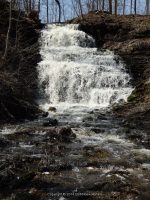
Waterfall Name: Clarendon Falls
Aka: Clarendon, Falls At
Location: Clarendon Twn
First Visit: 04-12-2014
State: New York State
Region: Western Region
County: Orleans County
Park Area: ————-
NYS Tourism Region: Niagara Frontier
NYDEC Region: Western Finger Lakes
Waterfall Challenge: ————-
Waterfall Location: N43.19178 W78.06597
Parking: N43.1917939 W78.0658924
Trailhead: N43.1917939 W78.0658924
Trail Name, Reference to: ————-
Stream, River: Sandy Creek, Tributary to
Height, Type: 26ft,Cascade
Elevation: 600 ft
Level of Difficulty, Hiking Distance: Short
Whitewater Rte, Canoe Rte Map: ————-
Maps: ————-
My Resource: Nyfalls
Book Resource: Waterfalls of New York State Paperback – August 9, 2012, by Scott Ensminger, David Schryver, Edward Smathers,Greater Niagara Region,pg150
Brochures, Travel Guides, Visitor Guides: ————-
Trail_URL: ————-
Additional Information: Town of Clarendon
Photos, Information Contributed to other Websites: Dig the Falls
Landmark: Small Park, lit up at night
Nearest Intersection: Highway 237 (Holley-Byron Rd) and Church Street
Directions: From I-90 W in Batavia, Take exit 48 to the right onto Rt-98 towards Batavia and drive for .9 miles. Take the Rt-98 N ramp to the right towards Albion and drive for 3.6 miles. Turn right onto Hwy 262 and drive for 5.6 miles. Turn left onto Byron Rd and drive for 1.4 miles. Turn left onto Hwy 237 and drive for .5 miles. Keep left onto Hwy 237 and drive for 6.2 miles.
Comments, Notes: Park in center of Clarendon
————-
————-
————-