
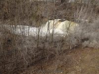
Waterfall Name: Medina Falls
Aka: ————-
Location: Medina Village
First Visit: 04-12-2014
State: New York State
Region: Western Region
County: Orleans County
Park Area: ————-
NYS Tourism Region: Niagara Frontier
NYDEC Region: Western Finger Lakes
Waterfall Challenge: ————-
Waterfall Location: N43.22246 W78.38314
Parking: N43.222718 W78.382255
Trailhead: N43.222718 W78.382255
Trail Name, Reference to: ————-
Stream, River: Oak Orchard Creek
Height, Type: 40ft,Cascade
Elevation: 503 ft
Level of Difficulty, Hiking Distance: 20 Minutes Rt, .5 mile
Whitewater Rte, Canoe Rte Map: ————-
Maps: Western New York All-Outdoors Atlas & Field Guide, 2008,C3,pg140
My Resource: Western New York All-Outdoors Atlas & Field Guide, 2008,C3,pg140
Book Resource: 200 Waterfalls in Central and Western New York: A Finder’s Guide Paperback – June 5, 2018, by Rich and Sue Freeman,Waterfalls in Niagara, Erie, Orleans, Genesee & Wyoming Counties,pg40
Brochures, Travel Guides, Visitor Guides: ————-
Trail_URL: ————-
Additional Information: ————-
Photos, Information Contributed to other Websites: Dig the Falls
Landmark: Erie Canal Heritage Trail/NYS Barge Canal
Nearest Intersection: Horan Rd and Laurel Street and Bank Street
Directions: From I-90 W in Pembroke, Take exit 48A to the right onto Rt-77 towards Pembroke/Medina and drive for 1 miles. Turn left onto Alleghany Rd and drive for 14.8 miles. Turn right onto Orient St and drive for .6 miles. Turn right onto E Center St and drive for .2 miles. Turn left onto State St and drive for .1 miles. Turn left onto Horan Rd and drive for .1 miles.
Comments, Notes: As soon as you turn onto Laurel street from Bank Street, there is a small parking area to your left with a gazebo and information koist.
————-
————-
————-