East Branch Fish Creek Waterfalls and Rapids (Whitewater Route)
East Branch Fish Creek Waterfalls and Rapids (Whitewater Route)
I am still trying to access all of these locations.
Driving Directions:
From I-90 W, in Westmoreland, Take exit 32 to the right towards Rt-233/Westmoreland/Rome and drive for .7 miles. Turn right onto Cider Street and drive for .1 miles. Turn right onto Highway 233 and drive for 5.7 miles. Take the Rt-49 W/Rt-69 W/Rt-365 W ramp to the left and drive for .4 miles. Take the Rt-49 W/Rt-69 W ramp to the right towards Rt-26 N/Rt-46/Downtown Rome and drive for 1.3 miles. Keep left onto Erie Blvd E and drive for 10.5 miles. Turn right onto Main Street and drive for .1 miles. Furnace Creek falls on Parking Continue on Main Street and drive north for .1 miles. Turn right onto Church Street and drive for .1 miles. Fish Creek Cabin Resort (Town Rapids and the Sand Pit) Get on Church Street and drive north for .1 miles. Turn right onto Main Street and drive for .4 miles. Turn right onto Coal Hill Road and drive for .9 miles. Turn right onto Palmer Road and drive for .6 miles. Palmer Road Parking (Palmer Road Rapids) Continue on Palmer Road and drive northeast for .3 miles. Palmer Road (Hotel California Rapids and Kellys Corner Rapids) Continue on Palmer Road and drive east for .1 miles. Turn left onto Boyd Road and drive for 1.1 miles. Fish Creek Dam Road Parking (Waterfall Wave Rapids and City of Rome Reservoir and First Wave) Continue onto Frenchtown Road and drive for .8 miles. Turn right onto Bowman Road and drive for .7 miles. Turn left onto Point Rock Road and drive for 2.4 miles. Point Rock Road Parking (Ice Pool) Continue on Point Rock Road and drive north and drive for 1 miles. Turn left onto Yorkland Road and drive for .3 miles. Yorkland Road -Put In
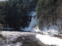
1 Furnace Creek (falls on)
Dates visited:
4-27-2014, 4-2-2014, 6-30-2013, 12-31-2012, 5-9-2007
There is a small memorial park near the bridge. Park there and walk to the bridge.
When you are standing on the Main Street bridge looking north, Furnace Creek flows into East branch Fish Creek on the left.
Location: Annsville Town
Closest Intersection: Main Street and Blossvale Road
Falls N43.30229 W75.61768
Parking N43.30227 W75.61828
Landmark: Small Memorial Park
Stream or River: Furnace Creek flows into Fish Creek
Elevation: 500 ft
Type: Ledges
Access: Roadside

——————————————————————————
11 Ice Pool (EB Fish Creek)
Dates visited:
Location: Lee Town
Closest Intersection: Point Rock Road and Sulphur Springs Road
Falls: N43.37394 W75.55711
Parking:
Landmark:
Stream or River: East Branch Fish Creek flows into Fish Creek
Elevation: 950 ft
Type: Cascade on River Walls
Access: Possible access N43.37368 W75.55118
——————————————————————–
12 Frederick W Parker Jr Bridge
Dates visited:
(4-27-2014) (4-2-2014) (6-30-2013) (12-31-2012) (5/9/2007)
This is used sometimes as a put in location
.
Location: Annsville Town
Closest Intersection:
Coal Hill Road (County Route 67a) and Sheehan Road
Falls: N43.37796 W75.56813
Parking: N43.37796 W75.56813
Landmark:
Stream or River:
Elevation: 1025 ft
Type:
Access: Roadside