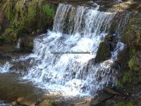
Buckley Hollow – 3 Waterfalls
Buckley Hollow – 3 Waterfalls
AKA: |
—– |
Location: |
Smithville Twn |
First Visit: |
4/17/2016 |
Region: |
Central |
County: |
Chenango |
Park/Area: |
—– |
Gps of Falls: |
—– |
Gps of Parking: |
N42.40109 W75.65945 |
Gps of Trailhead: |
—– |
Trail Name/Reference to: |
—– |
Landmark: |
Finger Lakes Trail white blazed |
Stream/River/Watershed: |
Bowman Creek |
Height of Falls/Type: |
several small cascades, drops, ledges |
Elevation: |
1203-1040 ft |
Level of Difficulty/Hiking Distance: |
Currently this section of the Finger Lakes Trail is only open for the first 1/4 mile. Due to logging the rest is closed and the other end is open. |
Wikiloc: |
|
Whitewater Rte/Canoe Rte Map: |
—– |
Maps: |
—– |
Trails Websites: |
—– |
My Resource: |
M25 Finger Lakes Trail Guide Maps |
Book Resource: |
—– |
Brochures/Travel Guides/Visitor Guides: |
—– |
Additional Information: |
|
Photos And Information I Contributed To or Posted To Other Websites: |
|
Nearest Intersection: |
Buckley Hollow Rd and Williams Rd |
Directions: |
From Hwy 12 and Hwy 206, in Greene, Get on Hwy 12 and drive northeast for 6.9 miles. Turn left onto Williams Rd and drive 1.8 miles.Turn left onto Buckley Hollow Rd, and park off to the side of the road. |
Comments/Notes: |
There is no technical real parking area for this location. Parking is anywhere safe at this “Y” intersection. Almost directly at the corner of Buckley Hollow Rd and Williams road is the Finger lakes trailhead. This trail goes thru private property, please stay on the trail. From the trail start, you will see a notice stating the trail is closed off in ¼ of a mile. As you leave the roadside you will come to a fence and a little ladder type thing in which you will use to climb over the wired fencing. Once over the fence the trail continues to the left along the edges of an open field. In about 400 ft you will entered the woods line again and will be following a well maintained trail. There is fence up all along the edge of the stream to your left. You cannot cross over this fence to get a closer view of the small falls along here. You have more of a birdseye view of this whole section. (To be honest this section is actually best viewed from walking along the roadside on Buckley Hollow road.) Continue along the trail and you will come to a section much similar to a bend in the road, here you have a good view of the bridge on Buckley hollow road. Continue along for about another 400 ft and you will come to the Second Main waterfall. Again these views are all birdseye to falls below. Here is where the trail is closed and you turn around and head back out the same way. If the trail was open there is the third waterfall. The trail continues all the way to Highway 12 entrance/exit of this section of the finger lakes trail. |
For additional information please click on the following links
Buckley Hollow Falls #1
Buckley Hollow Falls #2
Buckley Hollow Falls #3
Wikiloc-Buckley Hollow Waterfalls (Bowman Creek)
Powered by Wikiloc


