Taylorville Waterfalls (7 Waterfalls)
Taylorville Whitewater Section of the Beaver River
Lewis County, Town of Croghan
I have recorded the tracks for the upper waterfalls and trail only and can be viewed and downloaded, click on the following link.
Wikiloc Taylorville Whitewater Section
Date Visited: 9-7-2015
Stream or River: The Beaver River flows into the Black River
Resources Used:
Eastern New York All Outdoors Atlas and Field Guide Publication 2008 pg 106 B3
American Whitewater-Beaver River Taylorville Section
Beaver River Project
Adirondack Tug Hill Attractions
Directions:
From the intersection of Hwy 126 and Hwy 812 in Croghan, take Hwy 812 north for .7 miles. (At .4 miles is Croghan Island Falls) Turn Right onto Belfort Road and drive for 3.6 miles. (Take note at .6 miles you will see High Falls Road on your left and this leads to High Falls Dam.) (Take note that at about 3.2 miles Belfort road veers left. Also here is Belfort Falls and Dam). Turn right onto Long Pond Road and drive another .1 mile to Taylorville Road which bears right. Continue on Taylorville Road for .5 miles. (Note: just before you reach the end you will see a dirt road off to your left. This is Double Eddy Road and if you continue another .5 miles to the end, it will lead you to the other falls in this area.
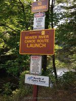
Parking Areas:
1-Double Eddy Road
N43.92734 W75.31376
2-End of Double Eddy Road
N43.92798 W75.31224
3-Taylorville Road
N43.92755 W75.32154
These photos are of the parking area before reaching the end of Double Eddy Road

Trail Description:
From the parking area near the end of Double Eddy road (Parking area photos shown above), you have two choices, either walk up to the end of Double Eddy Road and down to the start, or take the trail at the parking that starts after going under the penstock, either way it is about .2 miles. The trails are very easy to follow. I will describe how we went. We chose the trail right there by the parking. From the penstock, follow the wide trail down and to your left for about .2 miles. You will come out to the approximate area of the Beaverator Rapids. From here we turned left and followed the trail up about 280 ft to the put in location below the first dam. From here we walked over to the footbridge to take some snap shots of the kayakers starting off. We then crossed the bridge and went up the hill for about another 380 ft, that will take you to the top of both Dams and a nice view of Taylorville Pond. From here we retraced our steps back to the bottom of Taylorville Dam and Falls, (which is the second dam). In fact you can view both dams right from the walk bridge. From Taylorville Falls, we walked back down to the Beaverator Rapids section. At this point you will have walked .4 miles. Continue down the trail for about another .1 miles, which brings you to the top of the Great White Slide. You will find plenty of places to sit and relax and enjoy the view. From here you can either turn around and go back up or continue down the trail to the bottom of the Great White Slide. This trail will take you down and around to the picnic area on the other end of the lake. To continue on the trail, pick your way down and follow the trail around the lake for about .2 miles. Note: at .1 miles you will have come back to the trail you started at for the parking area. Continue left at this point to go to the picnic area. From the picnic area you will have a long distant view of the Great White Slide. From the location of the picnic table, continue straight a few hundred feet, and you will be at the top of the Dogleg Rapids. I could not figure out how to hop, skip and/or jump across to get to the top of the Mindscrambler. From here return back to the picnic table. Off to the left you will see a path that you can pick your way down to the bottom to get views of both the Dogleg Rapids and the Mindscrambler Rapids. Keep in mind that it does not appear as a very well used path. I would say most folks stop and turn around from the picnic area. This side scramble is about another 390 ft. At this point we decided to back track back to the parking area, and head down to the take out. I cannot tell you what the continuance of the trail maybe from the picnic area down to the take out. By the time you get back to the parking area you will now have walked about 1.1 miles. From here drive down to the Taylorville Power Plant, and park in designated areas. From there you will walk directly to the fence line headed towards the river. There is a gate that is open during events. From the gate you have two choices, taking the path straight ahead leads to the take out and a distant view of the Powerline Rapids. There was no trail at the take out that we could find to follow the river up. The other option is from the gate turn left and follow the penstock a short distance. Look for a pretty good travelled trail off to your right that leads down to Powerline Rapids. Take note that this path is not as well cared for as the trail for the upper waterfalls. You will have to pick your way down. The total distance down to the river and back maybe about .4 miles.
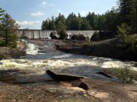
Photo Locations for the first two dam and falls:
On the walk bridge looking up to first dam
N43.92702 W75.31093 1067 ft
Taylorville Pond Top of first dam Taylorville Pond
N43.92771 W75.31070 1058 ft
Taylorville Pond Top of second dam
N43.92731 W75.31031 1093 ft
Taylorville Dam
Falls Location:
N43.92746 W75.31102
Elevation: 1046 ft
Type: Dam and Falls
First Dam and Put in Location

Views of the First Dam from the cross over bridge

Looking down from the top of the First Dam

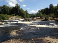
Taylorville Falls aka Double Eddies
Falls Location:
N43.92703 W75.31016
Elevation: 980 ft
Type: Dam and Falls

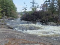
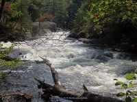
Beaverator IV-Rapids
Photo Location: Beaverator IV-Rapids
N43.92666 W75.31125
Falls Location:
N43.92618 W75.31102
Elevation: 1050 ft
Type: Class IV Rapids
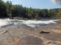
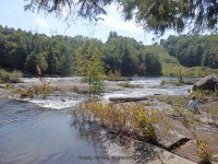
Great White Slide aka Taylorville Lower Falls
Photo Location: Great White Slide
N43.92552 W75.31224
Falls Location:
N43.92506 W75.31189
Height: 60 ft to 70 ft
Elevation: 1047 ft
Type: Long Slide Class III Rapids
Trail and Picnic area:
N43.92603 W75.31443

Photo Locations for Dogleg III Rapids and Mindscrambler Rapids
Photo Location: Dogleg III-Rapids
N43.92545 W75.31449
Photo Location: Looking back up at Dogleg Rapids and Mindscrambler
N43.92588 W75.31584
Dogleg III-Rapids
Falls Location:
N43.92532 W75.31463
Landmark: Right side of island
Elevation: 1025 ft
Type: Class III+ Rapids
Mindscrambler Rapids
Falls Location:
N43.92534 W75.31709
Landmark: Left side of island
Elevation: 1000 ft
Type: Narrow Sluice Class III Rapids
The photos here include Dogleg III Rapids and Mindscrambler Rapids
Taylorville Lower Trail (2)

Powerline Boof IV-Rapids
Falls Location:
N43.92592 W75.31846
Landmark: Power Plant
Height: 8 ft
Elevation: 975 ft
Type: Class IV Rapids Slide on left 8 ft Drop on right
Between Take Out and Powerline
Looking Down at Take Out

Taylorville Take Out
N43.92540 W75.32038