Updated Waterfall Locations in Franklin County New York 2-24-2016
Updated Waterfall Locations in Franklin County New York 2-24-2016

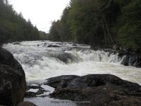
Raquette River Falls Trail
Moderate 9 Miles Round Trip
10 ft Cascade Rapids
6 ft Slide Rapids
8 ft Cascade Rapids


Updated Waterfall Locations in Franklin County New York 2-24-2016
Raquette River Falls Trail
Moderate 9 Miles Round Trip
10 ft Cascade Rapids
6 ft Slide Rapids
8 ft Cascade Rapids

Updated Waterfall Locations in Sullivan County New York 2-23-2016
These waterfall locations are in Sullivan County, New York, in the Towns of Fallsburg and Thompson.
Fallsburg Falls aka Old Falls Located in Fallsburg Town
Neversink River 3 ft Cascades Roadside

Tomsco Falls (Taylor Brook) aka Little Falls and Royalty Falls Located in Fallsburg Town
Taylor Brook 85 ft Multi-tiered Roadside
Katrina Falls Located in Thompson Town
Davies Lake Outlet 90 ft Horsetail


Updated Waterfall Locations in Sullivan County New York 2-22-2016
These waterfall locations are located in Sullivan County, New York, in the Town of Rockland.
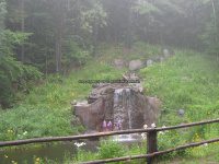
Sonoma Falls Country Market and Cider Mill has just opened for business about a week before we arrived. The folks were very friendly and shared their excitement of their grand opening. They have fishing, hiking trails, a snack bar, fresh cider, a gift shop. They talked about being open for the winter months providing sledding opportunities as well as access to the falls. There is a small fee to access the falls, but well worth it all.
You can view their website by clicking on this link Sonoma Falls
On the Little Beaver Kill, this Is A Six Tiered Waterfall. A moderate difficult trail and can be muddy or slippery at times.

Cattail Brook Falls aka Possible/Unconfirmed Bridal Veil Falls
Use caution getting down into there. It is not an official or even a well worn trail. Follow the stream down for more smaller falls. Cattail Brook Short Scramble


Updated Waterfall Locations in Sullivan County New York 2-21-2016
These waterfall locations are located in Sullivan County, New York in the Town of Liberty
There is a small rest area with picnic tables. You will find the small trail fairly easy and almost straight back from picnic tables. Located on the Little Beaver Kill this is a very Short Scramble.

There was a new restaurant built here. The sign stated opening soon. There was a high privacy fence on both sides of this building with no way to see the falls. The name of the place is Eden By The Falls. Located on the Mongaup River and is a 6 foot Drop that can be seen from the roadside.

You can see this waterfall from the bridge in the distance. Further up the road there is a trail that leads to the falls. Even though the trail looks very well warn, please also note there are posted signs right by the falls. Located on the Little Beaver Kill this waterfall is a 10 foot plunge and seen from the roadside.


Updated Waterfall Locations in Warren County New York 2-20-2016
The following waterfall locations are in Warren County, New York in the Towns of Lake Luzerne, Chester, and South Glens Falls.
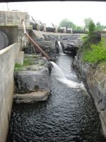
Glens Falls South Located in South Glens Falls, borders the counties of Warren and Saratoga
South Glens Falls Historical Park, The South Glens Falls Hydroelectric Project
Dam and Falls /Hudson River
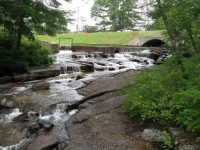
Mill Park Falls (Lake Luzerne) Located in Lake Luzerne Town
Mill Park Lake/Luzerne Village Park
25 ft Slide Roadside
Rockwell Falls (Lake Luzerne) aka Jessups Little Falls, Luzerne Falls
Located in Lake Luzerne Town, borders the counties of Warren and Saratoga
Rockwell Falls Church/Bridge Of Hope
Hudson River 10 ft Horseshoe Cascades Roadside
Trout Brook Falls (Adirondack Natural Stone Bridge and Caves) Located in Chester Town
Trout Brook 8 ft Various Types
Moderate to Difficult
Natural Stone Bridge and Caves
Natural Stone Bridge and Caves Park Map

Updated Waterfall Locations in Genesee County New York 2-15-2016
Buttermilk Falls (Leroy)
Oatka Creek 60 ft Plunge
We stopped at a home there and the access is now totally private no access available. The area is now owned by Dolomite, as of 4-13-2014
Indian Falls (Pembroke)
Tonawanda Creek 20 ft
Short walk
When we stopped in here, there must of been a bike convention or something, because the place was jam packed. We did not go over to the little patio, and we could see the gate was closed, so we took a couple of quick photos.
Be sure to plan your trip here and stop in for a bite to eat Indian Falls Log Cabin Restaurant

Morganville Falls in Hamlet Of Morganville
Black Creek 27 ft
We were looking for Morganville Falls, but where they appear to be looked posted. The path or trail that looked to be the one, someone was starting to plant flower beds along it. There are more photos of the location on the main page. Shown here is a picture of what we found driving in this area of town.


Updated Old Mill Falls (Flint Creek) in Ontario County New York 2-14-2016
Old Mill Falls (Flint Creek)
Flint Creek
11 ft and 4 ft Dam and Falls
Roadside


Updated Mill Drop Falls (Canandaigua Outlet) in Ontario County New York 2-13-2016
Mill Drop Falls (Canandaigua Outlet)
Private Property Roadside View Only
Canandaigua Outlet
10 ft Dam and Falls


Updated Double Drop Falls (Flint Creek) in Ontario County, New York 2-12-2016
Double Drop Falls (Flint Creek)
Flint Creek
10 ft and 5 ft Ledges
1.2 Mile Round Trip


Updated Waterfall Locations in Greene County, New York 2-9-2016
This concludes the waterfall locations I have for Greene County.
East Durham (falls in) Thorp Creek (Cornwallville Creek)
There is a small trail that leads to the edge of the cliff side where the falls can be seen. You can also view this from the top on the bridge. Use caution!!
 GREEN COUNTY SOUTHERN NEW YORK 8-17-2013_00003.JPG")
Woodstock Dam and Falls Catskill Creek
Although this location is posted, there were at least 20 people here that stated it was okay to access the area. The link provided in addition information is calling the waterfall there “The Woodstock Waterfall”. That location is Tannery Brook Falls in Ulster County.
 GREEN COUNTY SOUTHERN NEW YORK 8-17-2013_00007.JPG")
Bastion Falls aka Horseshoe Falls or Bastin Falls
This is also the beginning of the trail to Kaaterskill Falls. Even though this is roadside, parking is further up the road, and we had to walk quite far. The main parking area was full. From the main parking area, it is a .2 mile walk along the roadside.

Buttermilk Falls (Leeds) Green Lake Stream
The book indicates there are 3 falls here. I believe by the photos, we may have gotten a glimps of them. We have a hard time following the path, and crossing over the top of the falls looked rather sketchy.

Haines Falls
This is on private property. We asked the gate keeper permission to have access. We were not allowed to leave the roadside to get pictures any closer then what is shown here. The alternate long distant view is from the Layman’s Monument on the overlook up on Schutt Road.

Helena Falls
The Waterfall Motel is still there very run down and looks currently to now be a residence.


High Falls (Kiskatom) Kaaterskill Creek
The top of the lower portion can only be seen from the bridge.

Kaaterskill Creek falls on (Mossy Hill Road)
Above High Falls (Kiskatom)

High Falls Road Extention (falls on) Kaaterskill Creek
GREEN COUNTY SOUTHERN NEW YORK 8-18-2013_00006.JPG")
Kaaterskill Bridge (falls at) Kaaterskill Creek
Google imagery shows falls both above and below the bridge.
 GREEN COUNTY SOUTHERN NEW YORK 8-18-2013_00004.JPG")
Kaaterskill Falls
There are 2 access locations for the falls, you can choose to hike from the bottom up, which passes by Bastion Falls. This is a 1 1/2 mile round trip. The other access is from the top, which is located off of Laurel House Road. An easy trail leading to the top of the falls. Since I was here there have been changes made to the location of the falls due to the amount of injuries and deaths from folks getting to close to the edge. I plan to revisit this one in the future.

Kliens Falls
Roadside view from the bridge looking down or a short scramble from parking.

Rip Vanwinkle Falls aka Austin Falls and Leeds Falls and Great Falls
There is no access to this location as of our visit. There are posted signs everywhere. If anyone has information for access please let me know. Austin Glen Falls and Leeds Falls according to resources and google imagery shows the waterfall locations. Leeds Falls is listed as being above Rip Van Winkles Falls. Austin Glens Falls is below Route 23.