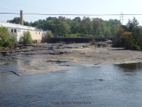
Beaver Falls and Dam Croghan aka Beaver Upper Falls
Lewis County, Croghan/New Bremen Town
Former names Beaverfalls, Castorville, Rohr’s Mills
Stream or River: Beaver River flows into the Black River
Resources Used:
Eastern New York All Outdoors Atlas and Field Guide Publication 2008 pg 106 B2
Google imagery shows falls here.
Beaver Falls and Dam Croghan aka Beaver Upper Falls
Dates Visited: 10/7/2006 9/5/2015
Closest Intersection: Highway 126 And Cutoff Road
Location: N43.88318 W75.42746
Parking: N43.88403 W75.42721
Landmark: Beaver Falls Recreation Park
Height: 12 ft
Elevation: 800 ft
Type: Dam and Falls
Hike: Roadside
Directions:
From the intersection of Highway 126 and Cut Off Road and Main Street in Beaver Falls, take Main Street North for less than .2 miles and the park will be on your left.
Beaver Falls and Dam 2 Croghan aka Beaver Lower Falls
Dates Visited: 9/5/2015
Closest Intersection: Main Street and Lewis Street
Location: N43.88435 W75.43036
Parking: N43.88464 W75.43190
Landmark: Fiber Technologies Omniafiltra Offices
Elevation: 775 ft
Type: Dam and Falls
Hike: Roadside
Directions:
From the Beaver Falls Recreation Park continue .3 miles north (Bear left at the Y intersection, which becomes Main Street) You will see Fiber Technologies Omniafiltra Offices on your left. Pull into the parking lot and go right and drive around to the back and park by the river. You will see the railroad tracks right there, from the railroad tracks over the river look upstream. Be careful when walking on the old railroad, as some of the boards were broken and unsteady.
Beaver Falls 3 Croghan
Date Visited: 9/5/2015
Closest Intersection: Highway 126 and Devines Road and Pinetree Lane
Location: N43.88554 W75.43453
Parking: N43.88575 W75.43655
Landmark: Lowville and Beaver River Railroad
Elevation: 750 ft
Type: Dam and Falls
Hike: Short
Directions:
From the Beaver Falls Recreation Park go back to Highway 126 and turn right. Drive .3 miles on Highway 126 and turn right onto Pinetree Lane. The paved road will end, continue onto the dirt road to its end. It is a total of .3 miles from the main road Highway 126.