
Independence River Falls on (5 Waterfalls)
Whitewater section of the Independence River
Donnattsburgh Road to Old Pine Grove Road
Lewis County, Town of Greig
The Independence River was named to honor the national holiday by surveyor/engineer Pierre Pharoux in the 1790’s. In those days, the French called the Salmon “La Famine.”
Named Waterfalls: This area is named the Independence River Falls and includes the following waterfalls and rapids: The Wall Rapids, Bridge Boof Rapids, Fat Lady Rapids, Boof III-Rapids and Powerline III Rapids.
I have recorded the tracks for the section of trail near the Rudd Road bridge. This can be viewed and downloaded, click on the following link.
Wikiloc Independence River Falls
Date Visited: 6/7/2015
I have not seen all of them. Plans to return in the future.
Stream or River: Independence River flows into the Black River
Resources Used:
Eastern New York All Outdoors Atlas and Field Guide Publication 2008 pg 106 D3
American Whitewater Independence River Donnattsburgh Road to Old Pine Grove Road
Directions:
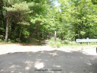
From the intersection of Highway 12 and Glenfield Road, drive .2 miles east on Glenfield Road. You will come to an intersection of Main Street. Turn left onto Main Street and drive .2 miles to a right onto Grieg Road. Drive .5 miles on Grieg Road to a left onto Otter Creek Road. Drive 1.5 miles on Otter Creek Road to the intersection of Pine Grove Road. Turn left here onto Pine Grove Road and drive 1.4 miles. Where Rudd Road is on your right. Turn onto Rudd Road and drive .3 miles to the end where the bridge is out. This is the take out spot for the whitewater rafters.
Comment: Northern New York Waterfalls has this location listed as Rudd Road falls on aka Hidden Falls.
Parking Areas:
Put In: Donnattsburg Road
N43.74708 W75.33344
Powerline Possible Parking: Oxbow Lane
N43.74168 W75.34586
Boof III-Rapids Possible Parking: Independence Lane
N43.73631 W75.35352
Falls Parking: Rudd Road
N43.73213 W75.36155
Take Out: Pine Grove Road
N43.73080 W75.36493
Trail Description:
Powerline III Rapids (Class III, Mile 1.4) Town of Turin
Closest Intersection: Rudd Road And Pine Grove Road
Location: N43.74271 W75.34621
Elevation: 883 ft
Type: Class III Rapids
Hike Distance: 2.6 Mile Round Trip
Boof III-Rapids (Class III+, Mile 2.1)
Closest Intersection: Chases Lake Rd and Independence Ln
Location: N43.73804 W75.35348
Elevation: 859 ft
Type: Class III+ Rapids
Hike Distance: 1.2 Mile Round Trip
Independence River Falls
Closest Intersection: Rudd Road And Pine Grove Road
Location: N43.73378 W75.35958
Height: 50 ft
Elevation: 825 ft
Type: Slides, Rapids
Hike Distance: .4 Mile Round Trip
Along West Side Trail
Photo Locations:
N43.73388 W75.36024
N43.73357 W75.36052
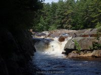
Fat Lady Rapids
Closest Intersection: Rudd Road And Pine Grove Road
Location: N43.73311 W75.36026
Landmark: Located in the area of the old diversion dam.
Elevation: 825 ft
Type: Slide Class IV+ Rapids
Hike Distance: .4 Mile Round Trip
Bridge Boof Rapids aka Rudd Road falls on aka Hidden Falls
Closest Intersection: Rudd Road And Pine Grove Road
Location: N43.73206 W75.36123
Landmark: Located at the bridge
Height: 50 ft
Elevation: 800 ft
Type: Rapids
Hike Distance: .5 Mile Round Trip
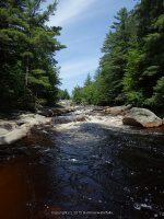

The Wall Rapids Independence River
Closest Intersection: Rudd Road And Pine Grove Road
Location: N43.73195 W75.36131
Landmark: Less than 200 feet below the bridge
Elevation: 775 ft
Type: Class IV Rapids
Hike Distance: Short
Photo Locations:
N43.73157 W75.36196 783 ft
N43.73166 W75.36174 776 ft

Independence River falls on Pine Grove Rd
Closest Intersection: Rudd Road And Pine Grove Road
Location: N43.73089 W75.36340
Elevation: 775 ft
Type: Rapids
Hike Distance: Roadside
Drive By

