
Waterfall Name: Beecher Creek Falls
Aka: ————-
Location: Edinburg Twn
First Visit: 05-10-2015
State: New York State
Region: Eastern Region
County: Saratoga County
Park Area: ————-
NYS Tourism Region: Capital-Saratoga
NYDEC Region: Eastern Adirondacks/Lake Champlain
Waterfall Challenge: Adirondack Fifty Falls Challenge: A Guide to the Fifty Falls, by John Haywood, Russell Dunn,Saratoga,pg94 and Hudson Valley Waterfall Challenge Paperback – March 9, 2020, by John Haywood,Saratoga,pg102
Waterfall Location: N43.22067 W74.10262
Parking: N43.22097 W74.10065
Trailhead: ————-
Trail Name, Reference to: ————-
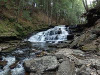
Stream, River: Beecher Creek
Height, Type: 20ft,cascade ledges with whats left of the dam above
Elevation: 850 ft
Level of Difficulty, Hiking Distance: Can be seen by the roadside or take the short path down to the covered bridge for view from the bottom of the falls. For view from the top of the falls take the short path to the overlook.
Whitewater Rte, Canoe Rte Map: ————-
Maps: Eastern New York all outdoors Atlas and Field Guide Publication 2008,B3,pg126
My Resource: Adirondack Waterfall Guide: New York’s Cool Cascades Paperback – September 1, 2003, by Russell Dunn,, C. Russell Dunn,I. Falls Along Route 30,pg24
Book Resource: Waterfalls of New York State Paperback – August 9, 2012, by Scott Ensminger, David Schryver, Edward Smathers,Capital Region,pg18
Brochures, Travel Guides, Visitor Guides: ————-
Trail_URL: ————-
Additional Information: http://www.coveredbridgesite.com/ny/copeland.html/New York State Covered Bridges, http://www.edinburgny.com/copelandbridgehistory.html, Welcome to the Town of Edinburg
Photos, Information Contributed to other Websites: Dig the Falls
Landmark: 1879 Historic Covered Bridge Arad Copeland
Nearest Intersection: North Shore Rd (Cr-4) and Military Rd and Olmstead Rd (Pucker St)
Directions: From I-90 Amsterdam, Take exit 27 to the right onto Rt-30 towards Amsterdam and drive for .4 miles. Take the Rt-30 N ramp to the right towards Rt-5s/Rt-5/Rt-67 and drive for 8.9 miles. Enter Roundabout for 221 ft. Take the 2nd right onto Hwy 30 and drive for 1.6 miles. Turn right onto North St. and drive for 14.3 miles. Turn right onto N Shore Rd and drive for .5 miles.
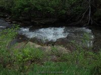
Comments, Notes: I also included the small falls you see right from the intersection as you turn to go down to the historical covered bridge.

Pingback: Hamilton, Saratoga County Waterfall Trip 5-10-2015 - Bobbieswaterfalls
Pingback: Waterfalls of New York State 100+ Challenge, Dig the Falls part 1, The Capital Region | Bobbieswaterfalls
Pingback: Road trip to Hamilton County New York area now published 5-10-2015 | Bobbieswaterfalls