
Waterfall Name: Beaver Falls and Dam #2, Croghan
Aka: Lower Falls, Boise Cascade Lower Dam
Location: Croghan/New Bremen Twn
First Visit: 09-05-2015
State: New York State
Region: Northern Region
County: Lewis County
Park Area: ————-
NYS Tourism Region: Adirondack Mountains
NYDEC Region: Western Adirondacks/Eastern Lake Ontario
Waterfall Challenge: ————-
Waterfall Location: N43.88370 W75.42890
Parking: N43.88464 W75.43190
Trailhead: ————-
Trail Name, Reference to: ————-
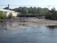
Stream, River: Moose River
Height, Type: Dam and Falls
Elevation: 775 ft
Level of Difficulty, Hiking Distance: Roadside view
Whitewater Rte, Canoe Rte Map: ————-
Maps: ————-
My Resource: Eastern New York All Outdoors Atlas and Field Guide Publication 2008 pg 106 B2
Book Resource: ————-
Brochures, Travel Guides, Visitor Guides: ————-
Trail_URL: ————-
Additional Information: Eagle Creek Renewable Energy
Photos, Information Contributed to other Websites: Dig the Falls
Landmark: Fiber Technologies Omniafiltra Offices
Nearest Intersection: Main St and Lewis St
Directions: From the Beaver Falls Recreation Park continue .3 miles north (Bear left at the Y intersection, which becomes Main St) You will see Fiber Technologies Omniafiltra Offices on your left. Pull into the parking lot and go right and drive around to the back and park by the river. You will see the railroad tracks right there, from the railroad tracks over the river look upstream. Be careful when walking on the old railroad, as some of the boards were broken and unsteady.
Comments, Notes: Former names Beaverfalls, Castorville, Rohr’s Mills Other Waterfalls nearby Beaver Falls and Dam Croghan, Beaver Falls 3 Croghan
————-
————-
