
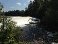
Waterfall Name: Belfort Dam And Falls
Aka: ————-
Location: Croghan Twn
First Visit: 09-05-2015
State: New York State
Region: Northern Region
County: Lewis County
Park Area: ————-
NYS Tourism Region: Adirondack Mountains
NYDEC Region: Western Adirondacks/Eastern Lake Ontario
Waterfall Challenge: ————-
Waterfall Location: N43.92634 W75.33154
Parking: N43.92780 W75.33263
Trailhead: ————-
Trail Name, Reference to: ————-
Stream, River: Beaver River
Height, Type: 25ft,Dam and Falls
Elevation: 950 ft
Level of Difficulty, Hiking Distance: Short
Whitewater Rte, Canoe Rte Map: ————-
Maps: http://www.adirondackstughill.com/maps/BeaverRiverCanoeRoute.pdf
My Resource: Eastern New York All Outdoors Atlas and Field Guide Publication 2008 pg 106 B3
Book Resource: ————-
Brochures, Travel Guides, Visitor Guides: ————-
Trail_URL: ————-
Additional Information: http://lowimpacthydro.org/lihi-certificate-7-beaver-river-project-new-york-ferc-2645/
Photos, Information Contributed to other Websites: ————-
Landmark: Belfort Pond Area
Nearest Intersection: Belfort Rd and Effley Falls Rd
Directions: From the intersection of Hwy 812 and Bridge St in Croghan, take Hwy 812 North for .2 miles and bear right onto Belfort Rd. On Belfort Rd drive 3.3 miles. Bear left here and drive another .1 miles to the parking area on your right just across the bridge.
Comments, Notes: The Dam and Falls on your right.There is also a flume/chute like falls across the bridge, but start under the bridge.
————-
————-
