
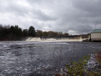
Waterfall Name: Denley Dam and Falls
Aka: ————-
Location: Leyden Twn
First Visit: 10-18-2014
State: New York State
Region: Northern Region
County: Lewis County
Park Area: ————-
NYS Tourism Region: Adirondack Mountains
NYDEC Region: Western Adirondacks/Eastern Lake Ontario
Waterfall Challenge: ————-
Waterfall Location: N43.54545 W75.32450
Parking: N43.54589 W75.32541
Trailhead: ————-
Trail Name, Reference to: ————-
Stream, River: Black River
Height, Type: Dam and Falls
Elevation: 875 ft
Level of Difficulty, Hiking Distance: Short
Whitewater Rte, Canoe Rte Map: ————-
Maps: ————-
My Resource: http://www.dec.ny.gov/outdoor/40629.html
Book Resource: ————-
Brochures, Travel Guides, Visitor Guides: ————-
Trail_URL: ————-
Additional Information: ————-
Photos, Information Contributed to other Websites: Dig the Falls
Landmark: Denley Dam Hydroelectric Project Ferc 5571-NY
Nearest Intersection: Hwy 12 North and Thomas Rd and Denley Lane
Directions: Head south on NY-12 for 2.8 miles, Destination will be on the left. Drive down in and park in the small parking area.
Comments, Notes: Accessed from the West side of the Black River (Leyden Town)
————-
————-
Pingback: Roadtrip on 10-18-2014 - Bobbieswaterfalls