
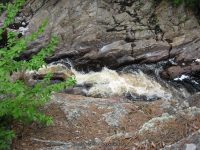
Waterfall Name: Gleasmans Falls
Aka: ————-
Location: Watson Twn
First Visit: 05-27-2010
State: New York State
Region: Northern Region
County: Lewis County
Park Area: Independence River Wild Forest
NYS Tourism Region: Adirondack Mountains
NYDEC Region: Western Adirondacks/Eastern Lake Ontario
Waterfall Challenge: ————-
Waterfall Location: N43.79951 W75.23667
Parking: N43.80719 W75.27520
Trailhead: ————-
Trail Name, Reference to: ————-
Stream, River: Independence River
Height, Type: 50ft
Elevation: 1300 ft
Level of Difficulty, Hiking Distance: 6.2 Round Trip
Whitewater Rte, Canoe Rte Map: ————-
Maps: ————-
My Resource: The Eastern New York All Outdoor Atlas and Field Guide Pg 107 D4 shows the trails, but does not show or list the actual falls.
Book Resource: www.lewiscountychamber.org
Brochures, Travel Guides, Visitor Guides: ————-
Trail_URL: https://www.alltrails.com/trail/us/new-york/gleasmans-falls-trail?ref=result-card
Additional Information: http://visitadirondacks.com/recreation/hiking
Photos, Information Contributed to other Websites: Northern New York Waterfalls
Landmark: Beach Mill Pond Trail Head
Nearest Intersection: Cleveland Lake Rd and Beach Mill Rd
Directions: From the intersection of Hwy 12 and Stowe St and River St (CR 26), in Lowville, take River St East for .7 miles. This is the intersection with East State St. Continue straight ahead here, still heading east. The road name changed from River St to Number Four Rd. Drive 6.3 miles. Turn right onto Losom Rd and drive .4 miles. Turn right onto McPhilmy Rd and drive 2.9 miles. Turn left onto Beach Mill Rd and drive 3 miles to its end at the Beach Mill Pond Parking Trailhead.
Comments, Notes: ————-
————-
————-