
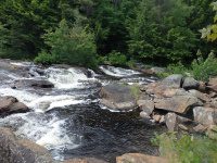
Waterfall Name: Grunerts Falls
Aka: ————-
Location: Croghan Twn
First Visit: 06-26-2016
State: New York State
Region: Northern Region
County: Lewis County
Park Area: ————-
NYS Tourism Region: Adirondack Mountains
NYDEC Region: Western Adirondacks/Eastern Lake Ontario
Waterfall Challenge: ————-
Waterfall Location: N43.97633 W75.23412
Parking: N43.97553 W75.23376
Trailhead: ————-
Trail Name, Reference to: ————-
Stream, River: West Branch Oswegatchie River
Height, Type: 25ft
Elevation: 1337 ft
Level of Difficulty, Hiking Distance: Short easy walk to the bridge overlooking the waterfall.
Whitewater Rte, Canoe Rte Map: ————-
Maps: ————-
My Resource: World Waterfall Database
Book Resource: ————-
Brochures, Travel Guides, Visitor Guides: ————-
Trail_URL: ————-
Additional Information: ————-
Photos, Information Contributed to other Websites: ————-
Landmark: Grunerts Camp And Inn Yellow Dec Markers For Iowa Trail Right Next To Fishing Access
Nearest Intersection: Long Pond Rd and Blue Swamp Rd
Directions: From the intersection of Hwy 812 and Old State Rd, in Croghan, Get on Old State Rd and drive southeast for 5 miles. Turn left onto Long Pond Rd and drive for 4.6 miles to parking area on the left just past the bridge.
Comments, Notes: ————-
————-