
Waterfall Name: Milkhouse Falls
Aka: ————-
Location: Turin Twn
First Visit: 01-19-2013
State: New York State
Region: Northern Region
County: Lewis County
Park Area: ————-
NYS Tourism Region: Adirondack Mountains
NYDEC Region: Western Adirondacks/Eastern Lake Ontario
Waterfall Challenge: ————-
Waterfall Location: N43.67565 W75.39749
Parking: N43.67634 W75.39794
Trailhead: ————-
Trail Name, Reference to: ————-
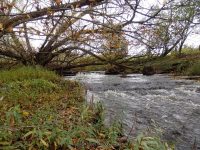
Stream, River: Douglas Creek
Height, Type: Drop
Elevation: 1050 ft
Level of Difficulty, Hiking Distance: Short
Whitewater Rte, Canoe Rte Map: ————-
Maps: ————-
My Resource: http://www.adirondackstughill.com/waterfalls.php
Book Resource: ————-
Brochures, Travel Guides, Visitor Guides: ————-
Trail_URL: ————-
Additional Information: ————-
Photos, Information Contributed to other Websites: Dig the Falls
Landmark: Behind the Orthodox Church
Nearest Intersection: Milk House Rd and Lee Rd
Directions: From the intersection of Hwy 12 and Glenfield Rd in Glenfield. Take Hwy 12 and drive south for 1.2 miles. Turn right onto Lee Rd and drive 1.5 miles.Turn left onto Milkhouse Rd. You will see the Orthodox Church right from the intersection.
Comments, Notes: The Orthodox Church is all posted. The location I accessed to take the photos was not posted. However I believe it should be and if it were there were no signs. It is a hazerdous area with lots of harmful things a person could get hurt! I could not get any closer then what you see here. (closed during fall for hunting)

————-
Pingback: ROADTRIP ON 10-18-2014 | Bobbieswaterfalls