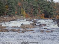
Waterfall Name: Moose River – Shurform Rapids
Aka: ————-
Location: Lyonsdale Twn
First Visit: 10-17-2015
State: New York State
Region: Northern Region
County: Lewis County
Park Area: ————-
NYS Tourism Region: Adirondack Mountains
NYDEC Region: Western Adirondacks/Eastern Lake Ontario
Waterfall Challenge: ————-
Waterfall Location: N43.61948 W75.32184
Parking: N43.61717 W75.32156
Trailhead: ————-
Trail Name, Reference to: ————-
Stream, River: Moose River
Height, Type: 25ft,(60ft slide) Class IV+ Rapids
Elevation: 988 ft
Level of Difficulty, Hiking Distance: Moderate 1 mile roundtrip
Whitewater Rte, Canoe Rte Map: http://www.americanwhitewater.org/content/River/detail/id/1352
Maps: ————-
My Resource: Eastern New York All Outdoors Atlas and Field Guide Publication 2008 pg 114 A3
Book Resource: ————-
Brochures, Travel Guides, Visitor Guides: ————-
Trail_URL: ————-
Additional Information: ————-
Photos, Information Contributed to other Websites: Dig the Falls
Landmark: Before Agers Falls on the Moose River Hiking Trail
Nearest Intersection: Lyonsdale Rd and Lowdale Rd
Directions: From the intersection of Hwy 12 and Hwy 12d in Lyons Falls, get on McAlpine St and drive northeast for .4 miles.Turn right onto Center St and drive for .5 miles. Turn left onto Laura St and drive for .8 miles. Bear left onto Lyonsdale Rd and drive for 1.3 miles. You will see a small parking area on the left side of the road. Before you get here you will see a sign indicating trail ahead. The trees were marked with green paint.
Comments, Notes: You will bypass Powerline Falls on the way.