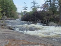
Waterfall Name: Taylorville – Beaverator Rapids
Aka: ————-
Location: Croghan Twn
First Visit: 09-07-2015
State: New York State
Region: Northern Region
County: Lewis County
Park Area: ————-
NYS Tourism Region: Adirondack Mountains
NYDEC Region: Western Adirondacks/Eastern Lake Ontario
Waterfall Challenge: ————-
Waterfall Location: N43.92618 W75.31102
Parking: N43.92798 W75.31224
Trailhead: ————-
Trail Name, Reference to: ————-
Stream, River: Beaver River
Height, Type: Class IV Rapids
Elevation: 1050 ft
Level of Difficulty, Hiking Distance: Easy less then .1 mile
Whitewater Rte, Canoe Rte Map: http://www.americanwhitewater.org/content/River/detail/id/2612/
Maps: ————-
My Resource: Eastern New York All Outdoors Atlas and Field Guide Publication 2008 pg 106 B3
Book Resource: ————-
Brochures, Travel Guides, Visitor Guides: ————-
Trail_URL: ————-
Additional Information: ————-
Photos, Information Contributed to other Websites: Dig the Falls
Landmark: Taylorville Pond
Nearest Intersection: Taylorville Rd and Double Eddy Rd
Directions: From the parking area at the end of Double Eddy road, head down the trail towards the river. You cannot miss this trail it is fairly wide and you can see quite a distance ahead. The trails are not clearly marked but easy to follow. The total loop we did was just about a mile. The waterfalls in order you will see starting from the parking area at the end of Double Eddy Rd are: Taylorville Dam, which is also the Put-in. The next Dam and Falls is called Taylorville Falls. The third is the Beaverators Rapids section. At .2 miles you will be at the top of the fourth one which is the Great White Slide also known as Taylorville Lower Falls. The fifth is the Dogleg Rapids and the sixth is the Mindscrambler. And the last is further down Powerline Boof Rapids
Comments, Notes: ————-