Waterfall Name: Whitaker Falls State Park
Aka: ————-
Location: Martinsburg Twn
First Visit: 09-23-2006
State: New York State
Region: Northern Region
County: Lewis County
Park Area: Whittaker Falls State Park
NYS Tourism Region: Adirondack Mountains
NYDEC Region: Western Adirondacks/Eastern Lake Ontario
Waterfall Challenge: ————-
Waterfall Location: N43.73563 W75.44938
Parking: N43.73586 W75.44552
Trailhead: ————-
Trail Name, Reference to: ————-
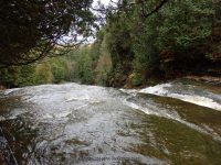
Stream, River: Roaring Brook
Height, Type: 40ft,Flume Tiered
Elevation: 1050 ft to 975 ft
Level of Difficulty, Hiking Distance: Short walk on uneven ground
Whitewater Rte, Canoe Rte Map: ————-
Maps: ————-
My Resource: New York Atlas & Gazetteer Delorme publication 2007 pg 84 C4
Book Resource: Waterfalls of New York State Paperback – August 9, 2012, by Scott Ensminger, David Schryver, Edward Smathers,North Country Region,pg168
Brochures, Travel Guides, Visitor Guides: www.lewiscountychamber.org
Trail_URL: ————-
Additional Information: http://www.adirondackstughill.com/maps/WaterfallsGuideBook.pdf
Photos, Information Contributed to other Websites: ————-
Landmark: ————-
Nearest Intersection: Glendale Rd and Jantzi Rd
Directions: At the intersection of Glenfield Rd and Hwy 12 in Glendale , take Glendale Rd southwest for 2.9 miles. (at .6 miles look for Swans Falls on your left). At 2.7 miles you will pass by Roaring Brook Upper Falls on your left) drive another .2 miles to the entrance to Whittaker State Park on your right. Drive down to the end of the dirt road to a small parking area near the playing field. You will pass by the camping and picnic area.
Comments, Notes: As of october of 2014, you could see there has been a lot of renovations to the park. However, the trail itself is in need of maintenance and repair. Use caution as you will be walking close to the edge of the gorge. The railings are old and broken, so do not rely on them for safety. There is a couple of overlooks, as well as a couple of stairs that lead you down closer for viewing from above. Sources are saying this is approximate 40 feet. At the very top is a flume type falls, not large, and then you have the next drop. Following that a short distance further down is another drop. All the photos are on my website. I believe there may have been another drop, but we could not access climbing down from top, or climbing up from the bottom. Offers camping and picnic facilities
————-
————-
