On the Black River trail
On the Black River trail. Jefferson County, New York


In Philadelphia NY
Philadelphia Waterfalls, Jefferson County, New York

Afraid of the dock!!
My granddaughter was a little scared of the dock!

Awesome campground Black River bay.
We had a blast, and everyone should try it for yourselves.

Tooley Pond Road Waterfalls (12 Named Waterfalls)
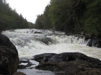
Whitewater Route Twin Falls Section of Grass River Lower South Branch
St Lawrence County, Town of Clare
Grasse River Wild Forest
Date Visited: 10/7/2010
Stream or River: Grass River Lower South Branch flows into the St Lawrence River
Resources Used:
Eastern NY All Outdoors Atlas and Field Guide Publication 2008 pg 99 A6
Eastern New York All Outdoors Atlas and Field Guide Publication 2008 pg 100 A1
Adirondack Waterfall Guide By Russell Dunn
Adk Park Map Saranac P. Smith
American Whitewater Grass River Lower South Branch
Adirondack Great Walks & Day Hikes A Guide to paths less taken in the Northeast’s last great wilderness. You can download or request brochures here
For additional information, click on the highlighted links:
Rainbow Falls aka Large Marge
Whip-it Good IV
Location: N44.31161 W75.00152
Type: Rapids
Landmark: Located between Rainbow Falls and Flat rock Falls at the .6 mile mark.
Flat Rock Falls IV
Location: N44.31841 W75.00759
Height: 25 ft
Type: Ledge slide drop, Tiered
Landmark: Camp Flat Rock
Bulkhead Falls
Location: N44.33146 W75.01765
Height: 25 ft
Type: Slide
Hike: Bulkhead Falls Trail, Maybe 16 Minutes Round trip
Landmark: Look For Sign That States No Motor Vehicle Access.
Adrenaline Falls IV
Location: N44 19.895 W75 01.303
Height: 12 ft
Type: Slide
Landmark: Before this there is a dirt road giving a good view of both falls. After this is the top of the falls, where the mill was located.
Stewart Rapids
Location: N44.33241 W75.02317
Height: 24 ft
Type: Rapids
Hike: Roadside
Twin Falls
Booney Falls
Location: N44.33376 W75.02931
Hike: Short
Landmark: Approximately .3 Mile North Of Twin Falls
Sinclair Upper Falls
Sinclair Falls aka Iron Bridge
Basford Falls
Degrasse Graffiti Rapids

Updated Waterfall Locations in Franklin County New York 2-24-2016

Raquette River Falls Trail
Moderate 9 Miles Round Trip
10 ft Cascade Rapids
6 ft Slide Rapids
8 ft Cascade Rapids

Updated Waterfall Locations in Warren County New York 2-20-2016
The following waterfall locations are in Warren County, New York in the Towns of Lake Luzerne, Chester, and South Glens Falls.
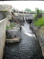
Glens Falls South Located in South Glens Falls, borders the counties of Warren and Saratoga
South Glens Falls Historical Park, The South Glens Falls Hydroelectric Project
Dam and Falls /Hudson River
Mill Park Falls (Lake Luzerne) Located in Lake Luzerne Town
Mill Park Lake/Luzerne Village Park
25 ft Slide Roadside
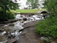
Rockwell Falls (Lake Luzerne) aka Jessups Little Falls, Luzerne Falls
Located in Lake Luzerne Town, borders the counties of Warren and Saratoga
Rockwell Falls Church/Bridge Of Hope
Hudson River 10 ft Horseshoe Cascades Roadside
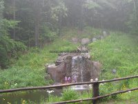
Trout Brook Falls (Adirondack Natural Stone Bridge and Caves) Located in Chester Town
Trout Brook 8 ft Various Types
Moderate to Difficult
Natural Stone Bridge and Caves
Natural Stone Bridge and Caves Park Map
Shurform falls