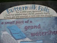
Buttermilk Falls State Park – 8 Named Waterfalls, Ithaca
Buttermilk Falls State Park – 8 Named Waterfalls, Ithaca
Buttermilk Falls State Park, Tompkins County, Ithaca, New York
Stream or River: Buttermilk Creek flows into Cayuga Lake
There are several falls of varying heights and types. Other named waterfalls here are: Pulpit Falls, Shower Bath Falls and Pinnacle Falls.
Dates Visited:
5/06/2012 7/15/2006 9/02/2006
I have yet to see all the falls here in the park. We only made it maybe to the top of the Main Falls due to it was really pouring rain that day. I wanted to include all the information I have accumulated since 2006. If the information I provided here is different or wrong, or you have additional information to provide, feel free to let me know.
Maps and Resources used to gather information:
Western New York all outdoors Atlas & Field Guide Publication 2008 103 C6
200 Waterfalls In Central & Western New York “A Finders’ Guide” By Rich And Sue Freeman 2002
New York Waterfalls “A Guide For Hikers & Photographers” by Scott E. Brown 2010
http://nyfalls.com/waterfalls/buttermilk-falls-state-park/
World Waterfall Database
Directions:
From I-81 S, in Whitney Point, Take exit 8 to the right onto Rt-79/US-11 towards Rt-26/Rt-206/Whitney Point/Lisle and drive .3 miles. Turn right onto US 11 and drive 29.5 miles. Keep left onto E State Street and drive .1 miles. Turn left onto S Aurora Street and drive .1 miles. Turn right onto Prospect Street for 252 ft. Bear left onto Prospect Street for 424 ft. Bear left onto E Spencer Street and drive .2 miles. Turn left onto S Cayuga Street for 165 ft. Keep right onto W Spencer Street and drive .2 miles. Enter roundabout Roundabout for 147 ft. Take the 2nd right onto Elmira Road and drive .4 miles. Bear right onto Elmira Road for 103 ft. Turn left onto Elmira Road and drive 1.1 miles. Turn left onto Buttermilk Falls Road E and drive .1 miles.
Length of Hike:
Gorge Trail: 0.75 miles. Strenuous
Rim Trail: 0.75 miles Strenuous
Bear Trail: 0.5 miles. Moderate
Lake Treman: 1.5 miles. Easy
Parking areas:
Parking N42.41718 W76.52123
Upper Parking Rd N42.40935 W76.51213
Upper Parking Rd 2 N42.40166 W76.51393
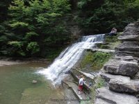
Buttermilk Creek And Falls aka Main Falls
Lower and Upper section has the viewing platform in the middle.
Falls: N42.41599 W76.52045
Height: 180 ft
Elevation: 450 ft
Type: Cascade
Pinnacle Falls in Buttermilk Falls State Park
Falls: N42.41111 W76.51654
Landmark: Pinnacle Rock
Height: 30 ft
Elevation: 833 ft
Type: 2 steps
Pulpit Falls in Buttermilk Falls State Park
Falls: N42 26.004 W76 29.100
Landmark: Pulpit Rock above the falls
Elevation: 750 ft
Type: 2 tiered
Shower Bath Falls in Buttermilk Falls State Park
Falls: N42.41060 W76.51509
Landmark: above Pinnacle Rock
Elevation: 850 ft
Lake Treman Falls
Falls: N42.40050 W76.51276
Owl Creek Falls
Falls: N42.41174 W76.51006
Height: 70 ft
Type: Steep Cascade
Starting from Highway 13 Buttermilk Falls Entrance North to South and parking areas
Waterfall Location Elevation
1 Buttermilk Creek Dam N42.41633 W76.52130 452 ft
2 Buttermilk Lower Falls N42.41599 W76.52045
3 Buttermilk Upper Falls N42.41507 W76.51953 610 ft
4 Waterfall in N42.41447 W76.51911 672 ft
5 Waterfall 1 N42.41365 W76.51854 741 ft
6 Waterfall 2 N42.41333 W76.51828 752 ft
7 Pulpit Falls N42.41303 W76.51804 778 ft
8 Buttermilk Creek bridge N42.41190 W76.51731 800 ft
9 Pinnacle Falls N42.41111 W76.51654 833 ft
10 Waterfall 3 N42.41070 W76.51544 846 ft
11 Shower Bath Falls N42.41060 W76.51509 850 ft
12 Flume Falls N42.41033 W76.51441 870 ft
13 Buttermilk Creek falls on N42.40892 W76.51263 874 ft
14 Buttermilk Creek falls on 2 N42.40273 W76.51101 904 ft
15 Lake Treman Falls N42.40065 W76.51291 951 ft
16 Owl Creek Falls N42.41162 W76.51002 873 ft
| Original content here is published under these license terms: | X |
|
| License Type: | General Public License | |
|
| License Abstract: | The GNU General Public License is a free, copyleft license for software and other kinds of works. You may re-publish the content (modified or unmodified) providing the re-publication is itself under the terms of the GPL. |
|
| License URL: | http://www.gnu.org/licenses/gpl.html |
Like this:
Like Loading...


")