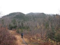
How many folks out there has starting their road trips and waterfalls? Any new adventures to share? So many places, so many destinations, and so many adventures! I see the whitewater folks heading into full action.
One of my Favorite photos from the Moose River
Moose River, Agers Falls, Lewis County, New York
So whats been going on with Bobbie andBobbieswaterfalls? Whats been going on with Digthefalls and the New York State Waterfall Collation? We have been down right busy working behind the scenes. Getting waterfall locations and information updated and available to the public. Our Team members are already out there hitting the roads for this new season. I soon hope to be getting out there myself.
Please continue to check back often, as I continue with my work on the revamp of the website. I have updated several counties, and several more to go. New pages are also being done on Digthefalls, be sure to check out the new features offered there as well.
Creating Your Own Adventure by Russell Dunn In the Spring 1997 issue of Kaatskill Life (a quarterly magazine devoted to the Catskills), I wrote an article entitled “Hunting for Waterfalls.” Little has changed since that piece was written. People still love to get out and hike to waterfalls. As it turns out, there are way…
Original content here is published under these license terms:
X
License Type:
General Public License
License Abstract:
The GNU General Public License is a free, copyleft license for software and other kinds of works. You may re-publish the content (modified or unmodified) providing the re-publication is itself under the terms of the GPL.
Bobbieswaterfalls, Improvements 2-19-2017
Just an update! I am still working on a lot of background improvements and changes to the website. At times there will be locations, or sections, that are unavailable. I have learned so much in the past few weeks, regarding pages, posts etc. Background work is more than I ever thought. The steps it takes to set up a proper working website that until now never understood their functions. So, hang in there, check back often. Thanks for all you patience as I work through it all.
Waterfalls in order: Morgan Dam (Village Falls), Sherman Falls, Potash Kettle and the Narrows ( Cascades Of The Alhambra), Lower High Falls, Upper High Falls, Mill Dam Falls (Upper Falls Or Squires Falls), and Hydro Dam and Falls.
Directions: From I-90, in Utica, Take exit 31 to the right towards I-790/Rt-8/Rt-12/Utica and drive for .8 miles. Take the Genesee Street North ramp to the right towards Rt-5/Rt-8/Rt-12/Rt-49/I-790 W/Watertown/Rome and drive for .4 miles. Keep left onto Trenton Road and drive for 1.6 miles. Continue on Cr-91 N towards Rt-12/Glass Factory Road and drive for .3 miles. Take the Rt-8 N/Rt-12 N ramp to the right and drive for 8.9 miles. Turn right onto Highway 28 and drive for .8 miles. Keep left onto Trenton Falls Road and drive for 1.2 miles, which takes you to the parking area. Parking area: Trenton Falls Rd N43.27489 W75.15850 The Primary trail (stone dust) is approximately 1 mile long. The secondary trails (wood mulch) follows along the gorge.
Listed in the order which the waterfalls will be seen: Morgan Dam at Trenton Falls Aka Village Falls
Upper High Falls at Trenton Falls 5-11-2014, 10-6-2012, 10-7-2006
P5110520.JPG (Bobbie Sweeting)
P5110522.JPG (Bobbie Sweeting)
P5110524.JPG (Bobbie Sweeting)
P5110526.JPG (Bobbie Sweeting)
TRENTON HIGH FALLS ONEIDA COUNTY CENTRAL NEW YORK 5-11-2014_00001.JPG (Bobbie Sweeting)
TRENTON HIGH FALLS ONEIDA COUNTY CENTRAL NEW YORK 5-11-2014_00003.JPG (Bobbie Sweeting)
TRENTON HIGH FALLS ONEIDA COUNTY CENTRAL NEW YORK 5-11-2014_00004.JPG (Bobbie Sweeting)
TRENTON HIGH FALLS ONEIDA COUNTY CENTRAL NEW YORK 5-11-2014_00005.JPG (Bobbie Sweeting)
TRENTON HIGH FALLS ONEIDA COUNTY CENTRAL NEW YORK 5-11-2014_00006.JPG (Bobbie Sweeting)
TRENTON HIGH FALLS ONEIDA COUNTY CENTRAL NEW YORK 5-11-2014_00007.JPG (Bobbie Sweeting)
TRENTON HIGH FALLS ONEIDA COUNTY CENTRAL NEW YORK 5-11-2014_00008.JPG (Bobbie Sweeting)
TRENTON HIGH FALLS ONEIDA COUNTY CENTRAL NEW YORK 5-11-2014_00009.JPG (Bobbie Sweeting)
TRENTON HIGH FALLS ONEIDA COUNTY CENTRAL NEW YORK 5-11-2014_00011.JPG (Bobbie Sweeting)
TRENTON HIGH FALLS ONEIDA COUNTY CENTRAL NEW YORK 5-11-2014_00013.JPG (Bobbie Sweeting)
TRENTON HIGH FALLS ONEIDA COUNTY CENTRAL NEW YORK 5-11-2014_00014.JPG (Bobbie Sweeting)
TRENTON HIGH FALLS ONEIDA COUNTY CENTRAL NEW YORK 5-11-2014_00016.JPG (Bobbie Sweeting)
TRENTON HIGH FALLS ONEIDA COUNTY CENTRAL NEW YORK 5-11-2014_00017.JPG (Bobbie Sweeting)
TRENTON HIGH FALLS ONEIDA COUNTY CENTRAL NEW YORK 5-11-2014_00018.JPG (Bobbie Sweeting)
TRENTON HIGH FALLS ONEIDA COUNTY CENTRAL NEW YORK 5-11-2014_00020.JPG (Bobbie Sweeting)
TRENTON HIGH FALLS ONEIDA COUNTY CENTRAL NEW YORK 5-11-2014_00021.JPG (Bobbie Sweeting)
TRENTON HIGH FALLS ONEIDA CENTRAL NY 10-06-2012_00001.JPG (Bobbie Sweeting)
TRENTON HIGH FALLS ONEIDA CENTRAL NY 10-06-2012_00002.JPG (Bobbie Sweeting)
TRENTON HIGH FALLS ONEIDA CENTRAL NY 10-06-2012_00003.JPG (Bobbie Sweeting)
TRENTON HIGH FALLS ONEIDA CENTRAL NY 10-06-2012_00006.JPG (Bobbie Sweeting)
TRENTON HIGH ONEIDA CENTRAL NY 10-07-2006_00001.JPG (Bobbie Sweeting)
TRENTON HIGH ONEIDA CENTRAL NY 10-07-2006_00002.JPG (Bobbie Sweeting)
TRENTON HIGH ONEIDA CENTRAL NY 10-07-2006_00003.JPG (Bobbie Sweeting)
TRENTON HIGH ONEIDA CENTRAL NY 10-07-2006_00004.JPG (Bobbie Sweeting)
TRENTON HIGH FALLS, ONEIDA COUNTY, CENTRAL, NEW YORK, 5-11-2014, 10-6-2012, 10-7-2006
The current trail stops here, back in 2006 I was thankful I had the opportunity to go to its end. Mill Dam Falls At Trenton Falls Aka Upper Falls Or Squires Falls
HYDRO DAM MILL DAM ONEIDA CENTRAL NY 10-07-2006_00001.JPG (Bobbie Sweeting)
HYDRO DAM MILL DAM ONEIDA CENTRAL NY 10-07-2006_00002.JPG (Bobbie Sweeting)
HYDRO DAM MILL DAM ONEIDA CENTRAL NY 10-07-2006_00003.JPG (Bobbie Sweeting)
HYDRO DAM MILL DAM ONEIDA CENTRAL NY 10-07-2006_00004.JPG (Bobbie Sweeting)
TRENTON FALLS HYDRO DAM, ONEIDA COUNTY, CENTRAL, NEW YORK 10-07-2006
I am still trying to narrow down exactly what section or falls the following are referred to historical. Bridal Veil Falls at Trenton Falls Suydam Falls at Trenton Falls
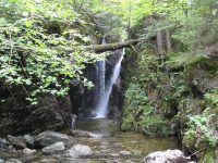
Moshier Upper Falls (4 Named Waterfalls)
Date Visited: 9-4-2016 Moshier Falls Section of the Beaver River Whitewater Route, Located in Lewis County, the Town of Watson, Adirondack Park Stream or River: Beaver River flows into the Black River
Moshier Upper Falls #1 Put-in slide
Parking Areas: Moshier Trailhead parking N43.87017 W75.13762 Moshier Road put in Parking only during whitewater events N43.88503 W75.10730 Points of Reference: Moshier Reservoir Dam and Falls N43.88752 W75.10920 1640 ft Trail entry N43.88385 W75.11946 Map at trailhead N43.87033 W75.13765 1492 ft Photo Locations: Photo location N43.88648 W75.11167, area where the put-in is Photo location N43.88629 W75.11927 Photo location N43.88635 W75.11942 For further information please click on the highlighted links Moshier Upper Falls #1 Put – in slide N43.88741 W75.10983 Moshier Upper Falls #3First Falls N43.88630 W75.11907 Moshier Upper Falls #4 Second Falls N43.88694 W75.11994 Moshier Upper Falls #5 Mauser’s Faceplant N43.88776 W75.12259 Moshier Upper Falls #2 Unnamed Rapids N43.88637 W75.11403 Moshier Upper Falls #6 Unnamed Rapids N43.88363 W75.12810 Moshier Upper Falls #7 Unnamed Rapids N43.88225 W75.13001 Moshier Upper Falls #8 Unnamed Rapids N43.88007 W75.13170 I have recorded the tracks for the Moshier Upper Falls section and trail which can be viewed and downloaded, click on the following link. Moshier Upper Falls
Original content here is published under these license terms:
X
License Type:
General Public License
License Abstract:
The GNU General Public License is a free, copyleft license for software and other kinds of works. You may re-publish the content (modified or unmodified) providing the re-publication is itself under the terms of the GPL.
Parking Areas: Moshier Trailhead parking N43.87017 W75.13762 1501 ft Moshier Road put in Parking only during whitewater events N43.88503 W75.10730 1653 ft Points of Reference: Moshier Reservoir N43.88703 W75.10820 1640 ft Moshier Dam N43.88752 W75.10920 1635 ft Falls N43.88358 W75.12785 1499 ft Falls N43.88234 W75.13003 1494 ft Falls (possible 10-12 ft falls mentioned in description on AW) N43.88038 W75.13161 1494 ft
Moshier Powerhouse/dam N43.87201 W75.13587 1449 ft
Trail marker N43.87194 W75.13778 1456 ft Map at trailhead N43.87033 W75.13765 1492 ft
Photo Locations: Bushwack in from trail N43.87436 W75.13593 1498 ft Falls #1 N43.87417 W75.13596 1485 ft Falls #2 N43.87379 W75.13604 1494 ft Falls #3 N43.87348 W75.13620 1497 ft Looking down at power plant N43.87327 W75.13633 1479 ft Bottom drop before power plant N43.87305 W75.13646 1454 ft Post marker N43.87397 W75.13698 1514 ft Foot bridge N43.87229 W75.13767 1445 ft Power Plant N43.87203 W75.13716 1444 ft
For more information please click on the highlighted links
Original content here is published under these license terms:
X
License Type:
General Public License
License Abstract:
The GNU General Public License is a free, copyleft license for software and other kinds of works. You may re-publish the content (modified or unmodified) providing the re-publication is itself under the terms of the GPL.
From County Rte 28 and Big Moose Rd, in Eagle Bay, Get on Big Moose Rd and drive north for 5.8 miles. Turn left onto Big Moose Rd and drive for 11.7 miles. Turn right onto Stillwater Rd, and drive .4 miles. Turn left onto Necessary Dam Rd and drive 1.2 miles to parking area for trailhead.
Comments/Notes:
—–
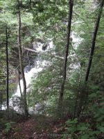
Shallow Pond Outlet Falls, Herkimer County, New York State, Waterfall
Original content here is published under these license terms:
X
License Type:
General Public License
License Abstract:
The GNU General Public License is a free, copyleft license for software and other kinds of works. You may re-publish the content (modified or unmodified) providing the re-publication is itself under the terms of the GPL.
Stream or River: Opalescent River flows into the Hudson River Date Visited: 10/15/2008 Resources Used: Eastern Ny All Outdoors Atlas And Field Guide Publication 2008 Pg 103 D4 Adirondack Waterfall Guide “New York’s Cool Cascades” By Russell Dunn Directions: From I-87 N South of North Hudson, Take exit 29 to the right towards Newcomb/North Hudson and drive .2 miles. Turn left onto Blue Ridge Road and drive 17.6 miles.Turn right onto Tahawus Road and drive .4 miles. Turn left onto Tahawus Road and drive another 5.9 miles. Turn left onto Upper Works Road and drive 3.5 miles to the parking area and trailhead. Trail Description: Calamity Brook Trail Hanging Spear Falls Moderate to Difficult over 5 miles one way Points of Reference and Photo Locations: Hanging Spears ParkingN44.08909 W74.056461780 ft Walkbridge Photos Hudson RiverN44.09217 W74.058001823 ft Henderson Lake PhotosN44.09337 W74.057341825 ft Trail Sign-parking Area SignN44.09388 W74.056981837 ft First Bridge With WaterfallCalamity BrookN44.10014 W74.043561934 ft From the first bridge and waterfalls to beginning trailhead
High Water Bridge PhotosN44.10689 W74.021212399 ft On the High Water BridgeCalamity BrookN44.10730 W74.020472405 ft Calamity BrookN44.10748 W74.020352418 ft David Henderson MonumentN44.11242 W73.999132685 ft From state boundry sign to henderson monument
David Henderson MonumentN44.11242 W73.999132685 ft Trailhead RegisterN44.11318 W73.993262757 ft Our Lean toN44.11123 W73.992102765 ft From henderson monument to lean to
Trail Turned AroundN44.10089 W73.990342442 ft Livingston Point Lean ToN44.11259 W73.988972767 ft Lean to photosFlowed LakeN44.11331 W73.989702756 ft From the dam to livingston lean to
Original content here is published under these license terms:
X
License Type:
General Public License
License Abstract:
The GNU General Public License is a free, copyleft license for software and other kinds of works. You may re-publish the content (modified or unmodified) providing the re-publication is itself under the terms of the GPL.
Date Visited: 8/11/2011 Resources Used: Eastern NY All Outdoors Atlas and Field Guide Publication 2008 pg 103 D6 Adirondack Waterfall Guide “New York’s Cool Cascades” By Russell Dunn World Waterfall Database Adirondack Waterways A Guide to paddling routes in the Northeast’s last great wilderness. You can download or request brochures here Trail Description: East River Trail and West River Trail It is approximately a 10 mile loop. The trail can be difficult and muddy, please use caution. Give yourself plenty of time, along with food and water. Be sure to carry along all necessary items, such as first aid kits, flashlights etc. Nearest Intersection: St Huberts Road And Ausable Club Road And Lake Road Directions: From I-87 N in North Hudson, Take exit 30 to the right onto US-9 towards Rt-73/Keene Valley/Keene and drive for .2 miles. Turn left onto US 9 and drive for 2.2 miles. Keep left onto Hwy 73 N and drive for 5.4 miles. Turn left onto Ausable Rd and drive for .2 miles to the parking area. Note: This is a re-construction of the hike. At the time of my visit, I did not use tracking devices. Distance does not included some of the spur trails. This is to the best of my ability. Points of reference, time and mileage included as close as possible. Arrived a parking area at 8:25 am Ausable Club Rd Parking N44.14903 W73.770271282 ft Arrived at the gate and sign in at 8:53 am (.5 mile walk down Ausable Club Road) St Huberts Rd and Ausable Club Rd and Lake Rd Parking N44.15066 W73.77899 Crossed over a wooden footbridge at 8:57 am (.3 miles) We are now .8 miles into the hike. Trail sign for WA White trail Lower Wolfjaw Snow Mtn and RoostercombN44.15010 W73.783991305 ft Crossed over a wooden footbridge at 9:10 am (.3 miles) We are now 1.1 miles into the hike. First trail sign for bear run Cathedral Rocks and Pyramid Brook N44.14678 W73.788841360 ft
Arrived at trail for Pyramid Brook at 9:38 am (.6 miles)We are now 1.7 miles into the hike. Second trail sign for direct route to pyramid brook near falls and Cathedral RockN44.14290 W73.799181524 ft
Arrived at trail for Wedge Brook Cascades at 10:58 am (.8 miles) We are now 2.5 miles into the hike. Wedge Brook Cascades Sign for Wedge Brook Cascades 200 yards, Wolfjaw, and Beaver Meadow Falls Lower Lake N44.13561 W73.81070
Arrived at Beaver Meadow Falls and crossed another wooden bridge about 11:38 am (.6 miles) We are now 3.1 miles into the hike. Beaver Meadow FallsE Branch Ausable River N44.12906 W73.815731912 ft Trail sign for Gothic and Armstrong N44.12867 W73.816841923 ft
Arrived at trail sign for Rainbow Falls at 11:41 am (.8 miles) We are now 3.9 miles into the hike. Trail sign for Gothics and Armstrong, west river trail and lower lake, and Rainbow FallsN44.11862 W73.825291954 ft Trail sign for Alfred w weld trail to gothics, rainbow falls N44.11861 W73.826412030 ft Arrived at Rainbow Falls at about 12:36 pm Rainbow FallsN44.11860 W73.82589
Trail sign for Indian Head Fishhawk Cliffs and Colvin N44.11756 W73.824092018 ft Trail Sign for Indian Head Fishhawk Cliffs N44.11410 W73.822022525 ft Arrived at Fishhawk Cliffs at about 2:16 pm (.7 miles) We are now about 4.6 miles into the hike. Trail sign for Indian Head, and Gothic Window 117 feet N44.11028 W73.823902497 ft Trail sign for road, Indian head, colvin, nipple top, fishhawk cliffs and Elk Pass.4 milesN44.11065 W73.816282442 ft Trail sign for road and gill brook trail, Indian head, colvin, nipple top, fishhawk cliffs .3 miles N44.11506 W73.815222283 ft
We are now at the start of the falls along Gill Brook 2:47 pm and at about 5.3 miles into the hike. From this point along Gill Brook Trail to Lake Road is another 1.2 miles giving it at 6.5 miles Gill Brook Falls 9 10 ftGill Brook N44.11999 W73.811252101 ft Gill Brook Falls 8 Long SlideGill Brook N44.12080 W73.810752071 ft Gill Brook Falls 7 FlumeGill Brook N44.12148 W73.810352055 ft Gill Brook Falls 6 25 ftGill Brook N44.12198 W73.810192026 ft Gill Brook Falls 5 9 ft CascadeGill Brook N44.12247 W73.810031994 ft Gill Brook Falls 4 15 ft FlumeGill Brook N44.12293 W73.809881972 ft Gill Brook Falls 2 ChuteGill Brook N44.12397 W73.809481918 ft
From this Trail sign at the end of the Gill Brook Trail (or the beginning) and back to the parking area is an additional 2.6 miles giving a total of about 9.1 miles. Trail sign for gill brook trail, gill brook colvin indian headLake Rd N44.12967 W73.806761701 ft
Original content here is published under these license terms:
X
License Type:
General Public License
License Abstract:
The GNU General Public License is a free, copyleft license for software and other kinds of works. You may re-publish the content (modified or unmodified) providing the re-publication is itself under the terms of the GPL.
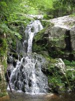
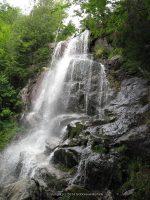
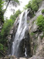
Eagle Falls ( 1 Main Waterfall and several small ones)
Eagle Falls ( 1 Main Waterfall and several small ones) Eagle Falls Section, Beaver River Whitewater Route Lewis County, Town of Watson Adirondack Park Date Visited: My first visit to the location was back in 2006. I revisited again on 9-7-2015 Stream or River: Beaver River flows into the Black River Resources Used: Beaver River Canoe Route Beaver River Project FERC 2645 New York Atlas & Gazetteer Delorme Publication 2007 Pg 85 A6 American Whitewater Eagle Falls I Love New York, Adirondacks Tug Hill Region Lewis County Visitor’s Guide Directions: From the intersection of Hwy 126 and Hwy 812 and Covent Road in Croghan, take Covent Road East for .3 miles. At this point Covent Road name changes to Kircherville Road. Continue East on Kircherville Road for 2.6 miles. At this point you will be at the intersection with Erie Canal Road. Continue straight. The road name now changed to Soft Maple Road, which is also Beaver River Road. Continue on Soft Maple Road for another 9 miles. Turn Left onto Canoe Launch Road for .7 miles. Which takes you to its end at the Eagle Falls Dam and Canoe Launch. From the beginning of Canoe Launch Road, (intersection of Maple Soft Road and Canoe Launch Road), you will pass by Eagle Falls Powerhouse and Scenic Overlook Falls. At about .3 miles you will come to the Eagle Falls takeout and Parking area, at which is the trail for the falls along their up to the dam. Note: I believe from this trail you are only looking at the bottom portion of Eagle Falls. I plan to go back next season.
Parking Areas: Eagle Falls put inN43.90172 W75.19481 Eagle Falls Take OutN43.90677 W75.19860 Eagle Falls PowerhouseN43.91001 W75.201421320 ft Soft Maple Parked before bridgeN43.91561 W75.225421320 ft Soft Maple Scenic Overlook Falls Area ParkingN43.91775 W75.229241285 ft
Points of Reference: Eagle ReservoirN43.89727 W75.190181431 ft Eagle Falls DamN43.90092 W75.193371431 ft Penstock beginsN43.90306 W75.195891413 ft Canoe rest areaN43.90696 W75.198731361 ft Penstock endsN43.90960 W75.200961302 ft Eagle Falls PowerhouseN43.91001 W75.20307 Upper Soft Maple ReservoirN43.91561 W75.220091293 ft Soft Maple ReservoirN43.91682 W75.22430 Soft Maple Development Overnight Camping AreaN43.91596 W75.224101305 ft
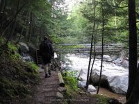
Trail Description: Parking at the Eagle Falls take out where the canoe rest area is, the trail starts here, and you can work your way up to the top where you will come to the base of the Eagle Falls Dam. Before I get into describing the section of trail we actually took, I want to state that to actually get to the Eagle Falls portion you will need to cross over a portion of the stream/river. We seen where someone had left a board there for crossing, but it really did not occur to us that it was the cross over access to the actual falls. From what I can tell, is that from the base of the Eagle Falls Dam, the section of river splits. Of course we did not know this, and would have known if we had known how to access at the top where the dam is. The best way for me to describe is standing at the dam and looking down, Eagle Falls would be to your right and we were to the left. I would like to call it an big huge rock Island, which I am sure is not the proper name. We plan to return to this location in the future. So, from the parking area, take the trail under the penstock and go right. The trail to begin with is very easy to follow. There were some very wet/muddy spots. For the most part the lower section of trail to where it meets the water is relatively easy to moderate. The last section, towards the top is difficult. The first .1 mile, there did not appear to be anything much going on. The first and second set of photos you will see before reaching the bottom of Eagle Falls. Your first view of the bottom portion of Eagle Falls is about .2 miles. In a couple hundred feet more, you will come to the section they call the overlook, as well as your about straight across from the bottom of Eagle Falls. From this point forward you need to use extreme caution as you now will be climbing upwards. It is about 250 feet to get to the bottom of this last section. If you follow the trail well above this last location you will not have a very good photo opportunity. However, if you go in from the bottom up, you will be walking on a slant, which is all flat smooth surfaced rock. When I say slippery, that is exactly what it was. We had leaves on top of moss. When you reached the top from here you will be standing at the base of the dam and beside the penstock. You will have to retrace your steps back down the trail, because at that point we could not figure out how to cross over to the road and just take the road back down. Total round trip is about .8 miles. For additional information click on the following links Eagle Falls Eagle Falls Dam Eagle Falls Lower Section Eagle Falls Powerhouse and Scenic Overlook Falls Eagle Falls Scenic Overlook Area Soft Maple Reservoir Dam and Falls I have recorded the tracks for the Eagle Falls section and trail which can be viewed and downloaded, click on the following link. Wikiloc Beaver River Whitewater Route Eagle Falls Section
Original content here is published under these license terms:
X
License Type:
General Public License
License Abstract:
The GNU General Public License is a free, copyleft license for software and other kinds of works. You may re-publish the content (modified or unmodified) providing the re-publication is itself under the terms of the GPL.