Moose River Waterfalls (16 Waterfalls)
The Bottom Moose River whitewater section Fowlersville Falls to Lyons Falls
Lewis County, Town of Lyonsdale
I have recorded the tracks for the and can be viewed and downloaded, click on the following link.
Wikiloc Fowlersville Falls Section
Wikiloc Lyonsdale Waterfalls
Wikiloc Agers Falls Recreation Area
Wikiloc Moose River Hiking Trail
Date Visited: 10/15/2006, 9/23/2006, 9/24/2006, 1/19/2013, 5/17/2014, 6/13/2014, 10/17/2014, 9/7/2015, 10/17/2015, 10/18/2015
Stream or River: The Moose River flows into the Black River
Stream or River: Black River flows into Lake Ontario
Resources Used:
Eastern New York All Outdoors Atlas and Field Guide Publication 2008 pg 115 A4
Eastern New York All Outdoors Atlas and Field Guide Publication 2008 pg 114 A3
American Whitewater Moose River Bottom of the Moose Fowlersville to Lyons Falls
I Love New York, Adirondacks Tug Hill Region Lewis County Visitor’s Guide
American Whitewater Moose River Lower Rock Island to Fowlersville
World Waterfall Database
Google imagery shows falls here.
Northern New York Waterfalls
Directions: Are written for each of the locations
Parking Areas: Are included with each of the locations
For this page, I am starting at the same location as the American Whitewater route starts for this section of waterfalls.
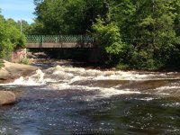
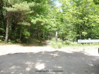
Fowlersville Bridge Rapids
Within the Adirondack Park
Nearest Intersection: Fowlersville Road and Youngs Road
Location: N43.62295 W75.27295
Parking: N43.62372 W75.27264
Landmark: Fowlersville Historical Bridge
Elevation: 1174 Ft
Type: Rapids
Hike: Easy Short
Directions:
From the intersection of Hwy 12 and Hwy 12d in Lyons Falls, get on McAlpine St and drive northeast for .4 miles.Turn right onto Center Street and drive for .5 miles. Turn left onto Laura Street and drive for .8 miles. Bear left onto Lyonsdale Road and drive for 2.6 miles. Bear left onto Hunkins Road and drive 1.1 miles. Turn left onto Fowlerville Road and drive 1.5 miles to the bridge over the Moose River. Just past the guard rails of the bridge on the right you will see a dirt road. Pull down into the small parking area. The best view is from the bridge.
From this area look back down towards the bridge and beyond you can see the top of Fowlersville Falls.
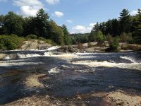
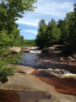
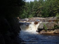
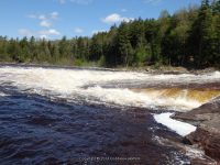
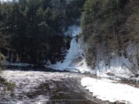
Fowlersville Falls and Lower Falls
Nearest Intersection: Fowlersville Road and Youngs Road
Location: N43.62360 W75.27800
Location for Lower Falls: N43.62406 W75.27765
Parking: N43.62431 W75.27400
Parking: N43.62450 W75.27600
Located within the Adirondack Park
Landmark: Fowlersville Historical Bridge
Height: 20 ft
Elevation: 1150 ft
Type: Slide Class IV+ Rapids
Hike: Moderate .4 mile round trip from the trail south of the river and an easy 1.2 mile roundtrip walking the dirt road north of the river.
Directions:
From the intersection of Highway 12 and Highway 12d and McAlpine Street, drive east on McAlpine Street for .4 miles. Turn right onto Center Street and drive .5 miles. (Note: at .3 miles Center Street changes to Franklin Street). Turn left onto Laura Street and drive .8 miles bearing left onto Lyonsdale Road. Continue on Lyonsdale Road for 2.4 Miles. Bear right onto Marmon Road and drive .3 miles. At this point Marmon Road goes to your right. Bear left onto Hunkins Road and drive 1.1 mile to its intersection with Fowlersville Road. Turn left onto Fowlersville road and drive 1.4 miles. You will see a small parking area on your left just before the bridge. From the parking area, facing towards the river, head into the woods. You will see a couple of paths from the start, but they lead into one and then follow the river downstream.
Another access is from the other side of the river. To get to there, from this location, cross over the Fowlersville bridge and go another .2 miles. You will see a dirt road on your left. I took this dirt road in my jeep down into the parking area by the river. From the parking area follow the path that leads downstream.
Photo Locations:
N43.62465 W75.27601
N43.62446 W75.27690
N43.62441 W75.27690
N43.62432 W75.27711
N43.62417 W75.27813
N43.62402 W75.27825
N43.62327 W75.27843
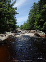
Moose River N43.62298 W75.28072 1150 ft
Moose River N43.62419 W75.28342 1125 ft
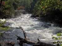
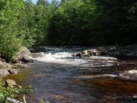
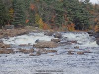
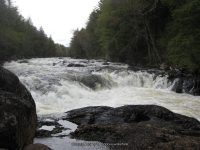
Funnel III Rapids Moose River (Class III+, Mile 0.7)
was here but did not see
Nearest Intersection: Fowlersville Road and Youngs Road
Location: N43.62201 W75.28675
Parking: N43.62431 W75.27400
Maybe accessed from the Moose River hiking trail
Elevation: 1125 ft
Type: Class III+ Rapids
Hike: Mile 0.7
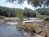
Knifes Edge Rapids Moose River aka Sliding Rock
Nearest Intersection: Lowdale Road and Marmon Road and Lyonsdale Road
Location: N43.61947 W75.29815
Parking: N43.61842 W75.30484
Landmark: Burrows Paper Company
Elevation: 1100 ft
Type: Rapids
Hike: Moderate .8 mile round trip
Directions:
From the intersection of Highway 12 and Highway 12d and McAlpine Street, drive east on McAlpine Street for .4 miles. Turn right onto Center Street and drive .5 miles. (Note: at .3 miles Center Street changes to Franklin Street). Turn left onto Laura Street and drive .8 miles bearing left onto Lyonsdale Road. Continue on Lyonsdale Road for 2.4 Miles. Turn left into the first parking area, which will be just pass the Burrows Paper Company on your left. I first parked in the burrows paper company parking lot and walked over behind the building. Then I went just past the building and parked in the upper parking lot and walked over to the walk bridge. From the parking area you will see a small footbridge, that crosses over the river. At some point in time this use to be an actual road called Lyonsdale Road. As you are standing on the bridge look upstream, well above the bridge and you can see the falls in the distance. Continue across the bridges and just past that to your right you will see a path and sign marking the trail. This trail will take you to both Double Drop Falls and Knifes Edge Falls
In this location there are 4 waterfalls, Lyonsdale Falls, T-Bone Falls, Double Drop Falls and Knifes Edge Falls. The first three can be seen right from the bridge.
Photo Locations:
N43.61904 W75.29892
N43.61936 W75.29863
N43.61939 W75.29862
Double Drop Rapids
Nearest Intersection: Lowdale Road and Lyonsdale Road
Location: N43.61802 W75.30076
Parking: N43.61842 W75.30484
Landmark: Burrows Paper Company
Height: 10 ft
Elevation: 1075 ft
Type: Steps Class IV Rapids
Hike: Roadside or .6 mile roundtrip to base of falls
Directions:
From the intersection of Highway 12 and Highway 12d and McAlpine Street, drive east on McAlpine Street for .4 miles. Turn right onto Center Street and drive .5 miles. (Note: at .3 miles Center Street changes to Franklin Street). Turn left onto Laura Street and drive .8 miles bearing left onto Lyonsdale Road. Continue on Lyonsdale Road for 2.4 Miles. Turn left into the first parking area, which will be just pass the Burrows Paper Company on your left. I first parked in the burrows paper company parking lot and walked over behind the building. Then I went just past the building and parked in the upper parking lot and walked over to the walk bridge. From the parking area you will see a small footbridge, that crosses over the river. At some point in time this use to be an actual road called Lyonsdale Road. As you are standing on the bridge look upstream, well above the bridge and you can see the falls in the distance. Continue across the bridges and just past that to your right you will see a path and sign marking the trail. This trail will take you to both Double Drop Falls and Knifes Edge Falls
In this location there are 4 waterfalls, Lyonsdale Falls, T-Bone Falls, Double Drop Falls and Knifes Edge Falls. The first three can be seen right from the bridge.
Photo Locations:
N43.61826 W75.29981
N43.61828 W75.30109
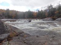
Lyonsdale Falls
Nearest Intersection: Lowdale Road and Lyonsdale Road
Location: N43.61907 W75.30398
Parking: N43.61842 W75.30484
Landmark: Burrows Paper Company
Height: 20 ft
Elevation: 1045 ft
Type: Cascade
Hike: Roadside
Directions:
From the intersection of Highway 12 and Highway 12d and McAlpine Street, drive east on McAlpine Street for .4 miles. Turn right onto Center Street and drive .5 miles. (Note: at .3 miles Center Street changes to Franklin Street). Turn left onto Laura Street and drive .8 miles bearing left onto Lyonsdale Road. Continue on Lyonsdale Road for 2.4 Miles. Turn left into the first parking area, which will be just pass the Burrows Paper Company on your left. I first parked in the burrows paper company parking lot and walked over behind the building. Then I went just past the building and parked in the upper parking lot and walked over to the walk bridge. From the parking area you will see a small footbridge, that crosses over the river. At some point in time this use to be an actual road called Lyonsdale Road. As you are standing on the bridge the falls are directly under the footbridge. The best view is from the parking lot on the other side of the Burrows Paper Company.
In this location there are 4 waterfalls: T-Bone Falls, Double Drop Falls and Knifes Edge Falls. The first three can be seen right from the bridge.
T-Bone Falls
Nearest Intersection: Lowdale Road and Lyonsdale Road
Location: N43.61879 W75.30458
Parking: N43.61842 W75.30484
Landmark: Burrows Paper Company
Height: 20 ft
Elevation: 1045 ft
Type: Slide
Hike: Roadside
Directions:
From the intersection of Highway 12 and Highway 12d and McAlpine Street, drive east on McAlpine Street for .4 miles. Turn right onto Center Street and drive .5 miles. (Note: at .3 miles Center Street changes to Franklin Street). Turn left onto Laura Street and drive .8 miles bearing left onto Lyonsdale Road. Continue on Lyonsdale Road for 2.4 Miles. Turn left into the first parking area, which will be just pass the Burrows Paper Company on your left. I first parked in the burrows paper company parking lot and walked over behind the building. Then I went just past the building and parked in the upper parking lot and walked over to the walk bridge. From the parking area you will see a small footbridge, that crosses over the river. At some point in time this use to be an actual road called Lyonsdale Road. From the end of the footbridge, look ahead to your left and you will see the falls.
In this location there are 4 waterfalls, Lyonsdale Falls, Double Drop Falls and Knifes Edge Falls. The first three can be seen right from the bridge.
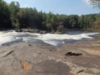
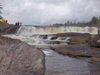
Agers Falls
Nearest Intersection: Lyonsdale Road And Lowdale Road
Location: N43.62183 W75.31229
Parking: N43.62164 W75.31375
Landmark: Agers Falls Recreational Area
Height: 18 ft
Elevation: 1000 ft
Type: Block Class III Rapids
Hike: Easy short walk to the Main Falls and additional .4 mile roundtrip to the Lower Falls.
Directions:
From the intersection of Hwy 12 and Hwy 12d in Lyons Falls, get on McAlpine St and drive northeast for .4 miles.Turn right onto Center Street and drive for .5 miles. Turn left onto Laura Street and drive for .8 miles. Bear left onto Lyonsdale Road and drive for 1.5 miles. Turn left into the Agers Falls recreation area. Turn left again and drive down to the end to the lower parking area.
From the lower parking area, there is a trail going further downstream. Take this trail for about .2 miles and it will bring you to the Lower Falls. The trail is marked with green paint on the trees. This trail also connects to the trail you would use to access Powerline Falls and Shurform Falls.
Photo Locations:
N43.62184 W75.31286
Agers Lower Falls
Nearest Intersection: Lyonsdale Road And Lowdale Road
Location: N43.62270 W75.31594
Parking: N43.62164 W75.31375
Landmark: Agers Falls Recreational Area
Height: 8 ft
Elevation: 1016 ft
Type: Rapids
Hike: Moderate .4 mile round trip
Directions:
From the intersection of Hwy 12 and Hwy 12d in Lyons Falls, get on McAlpine St and drive northeast for .4 miles.Turn right onto Center Street and drive for .5 miles. Turn left onto Laura Street and drive for .8 miles. Bear left onto Lyonsdale Road and drive for 1.5 miles. Turn left into the Agers Falls recreation area. Turn left again and drive down to the end to the lower parking area.
From the lower parking area, there is a trail going further downstream. Take this trail for about .2 miles and it will bring you to the Lower Falls. The trail is marked with green paint on the trees. This trail also connects to the trail you would use to access Powerline Falls and Shurform Falls.
Photo Locations:
N43.62254 W75.31562
N43.62270 W75.31594
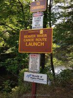
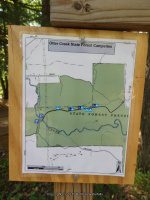
Moose River Hiking Trail
Location: N43.61574 W75.32422
Elevation: 947 ft
Photo Location:
N43.61563 W75.32424
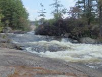
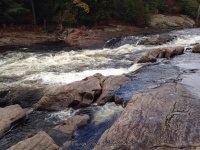
Shurform Rapids
Nearest Intersection: Lyonsdale Road And Lowdale Road
Location: N43.61948 W75.32184
Parking: N43.61717 W75.32156
Landmark: Before Agers Falls on the Moose River Hiking Trail
Height: 25 ft
Elevation: 988 ft
Type: Class IV+ Rapids
Hike: Moderate 1 mile round trip
Directions:
From the intersection of Hwy 12 and Hwy 12d in Lyons Falls, get on McAlpine St and drive northeast for .4 miles.Turn right onto Center Street and drive for .5 miles. Turn left onto Laura Street and drive for .8 miles. Bear left onto Lyonsdale Road and drive for 1.3 miles. You will see a small parking area on the left side of the road. Before you get here you will see a sign indicating trail ahead. The trees were marked with green paint.
You will bypass Powerline Falls on the way.
Photo Locations:
N43.61817 W75.32415
N43.61878 W75.32234
N43.61915 W75.32219
N43.61932 W75.32192
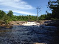
Powerline Rapids
Nearest Intersection: Lyonsdale Road And Lowdale Road
Location: N43.61657 W75.32562
Parking: N43.61717 W75.32156
Landmark: Before Agers Falls on the Moose River Hiking Trail
Height: 20 ft
Elevation: 956 ft
Type: Class III+ Rapids
Hike: Moderate .2 mile round trip
Directions:
From the intersection of Hwy 12 and Hwy 12d in Lyons Falls, get on McAlpine St and drive northeast for .4 miles.Turn right onto Center Street and drive for .5 miles. Turn left onto Laura Street and drive for .8 miles. Bear left onto Lyonsdale Road and drive for 1.3 miles. You will see a small parking area on the left side of the road. Before you get here you will see a sign indicating trail ahead. The trees were marked with green paint.
Shurform Falls is an additional .3 miles upstream from Powerline.
Photo Locations:
N43.61650 W75.32538
Crystal Falls
Nearest Intersection: Lyonsdale Road and Shibley Road
Location: N43.61473 W75.32857
Parking: N43.61345 W75.32694
Landmark: Fortisus Facility
Height: 30 ft
Elevation: 900 ft
Type: Cascade Class 5.1 Rapids
Hike: Easy to Difficult, depending on if you go down closer to the river. This is a steep bank.
Directions:
From the intersection of Hwy 12 and Hwy 12d in Lyons Falls, get on McAlpine St and drive northeast for .4 miles.Turn right onto Center Street and drive for .5 miles. Turn left onto Laura Street and drive for .8 miles. Bear left onto Lyonsdale Road and drive for .8 miles. This will be the entrance for the Fortisus Energy Plant. There is a small parking area on the side of the road. Walk straight back to the river, to view the falls.
This access is available during the times of the year that the Moose River Fest is being held. Just up river from here you can view Powerline Falls.
Magilla Falls aka Kosterville Falls
Nearest Intersection: Shibley Road and Kosterville Road
Location: N43.61385 W75.33118
Parking: N43.61392 W75.33517
Landmark: Kosterville Site
Height: 25 ft
Elevation: 886 ft
Type: Curtain Cascade Class 5.1 Rapids
Hike: Easy Short
Directions:
From the intersection of Hwy 12 and Hwy 12d in Lyons Falls, get on McAlpine St and drive northeast for .4 miles.Turn right onto Center Street and drive for .5 miles. Turn left onto Laura Street and drive for .8 miles. Bear left onto Lyonsdale Road and drive for .4 miles. Turn left onto Shibley Road. Drive .3 miles crossing over the Moose River and turn right into the entrance of the powerplant. Park in the lower parking area before the building and walk down to the river.
Goulds Mills Falls is located downstream, just across the bridge.
Goulds Mills Falls
Nearest Intersection: Kosterville Road And Shibley Road
Location: N43.61304 W75.33826
Parking: N43.61454 W75.33701
Landmark: Gouldtown Site
Height: 30 ft
Elevation: 825 ft
Type: Segmented Dam and Falls
Hike: Moderate Short
Directions:
From the intersection of Hwy 12 and Hwy 12d in Lyons Falls, get on McAlpine St and drive northeast for .4 miles.Turn right onto Center Street and drive for .5 miles. Turn left onto Laura Street and drive for .8 miles. Bear left onto Lyonsdale Road and drive for .4 miles. Turn left onto Shibley Road. Drive .3 miles crossing over the Moose River and turn left onto Kosterville Road. You will almost immediately see a small parking area on the right side of the road. From the parking area, cross the road and follow the short trail down to the river.
Magilla Falls is also in this same location. From the bridge on Shibley Road, and almost across from kosterville Road, you will see the entrance on your right.
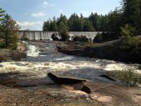
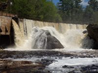
Lyons Falls aka High Falls
West Turin Town
Nearest Intersection: Lyons Falls Road And Kosterville Road
Location: N43.61909 W75.35797
Parking:
First parking is view from the top N43.61978 W75.35634
Second parking area is at the bottom N43.62085 W75.35695
Landmark: Power plant there are signs for fishermen parking both at the bottom and top of the falls
Stream or River: Black River flows into Lake Ontario
Height: 63 ft
Elevation: 775 ft
Type: Dam And Cascade
Hike: Short
Directions:
From the intersection of Hwy 12 and Hwy 12d and McAlpine St(Hwy 12D) in Lyons Falls, Get on McAlpine St (Hwy 12D) and drive northeast for .4 miles.Turn right onto Center Street and drive .5 miles. (Take note that Center Street name changes to Franklin Street). Turn left onto Laura St and drive .2 miles. Turn left onto Lyons Falls Rd and drive .4 miles.
Use caution when accessing the falls from the top area.
| Original content here is published under these license terms: | X |
|
| License Type: | General Public License | |
|
| License Abstract: | The GNU General Public License is a free, copyleft license for software and other kinds of works. You may re-publish the content (modified or unmodified) providing the re-publication is itself under the terms of the GPL. |
|
| License URL: | http://www.gnu.org/licenses/gpl.html |