Category Archives: Waterfalls of the Central Region of New York State

Asking for help in clarifying some Waterfalls in Cayuga and Cortland County NY

Asking for help in clarifying some Waterfalls in Cayuga and Cortland County NY

Asking for help in clarifying some Waterfalls in Cayuga and Cortland County NY
I am trying to put together a road trip down to the Tinkers Falls area. I have been to Tinkers Falls, and tried to get to Spicer Falls, but trail to Spicer’s Falls was closed. There is some confusion as to possible different names for same locations, but I cannot get clarifications for them. Does anyone have any insight or clarity, or access information for the following waterfalls:
Chippewa Falls  N42.71392 W75.88605 Chenango/Cortland
Chippewa Falls N42.70444 W75.89391 Chenango/Cortland
Eddy Creek Falls N42.39137 W75.61650 Chenango
Enchanted Hollow Falls aka Hemlock Falls N42.76600 W76.01683 Cortland
Irish Hollow Falls N42.71273 W75.94142 Cortland
Maxom Creek Falls N42.71358 W75.94246 Cortland
Midlum Falls N42.71945 W75.94121 Cortland
Morgan Hill Falls N42.72538 W76.00162 Cortland

Thank you for any help you can provide, to help clear up my confusions for this area.

Twitchell Creek, Falls on (5 Waterfalls)

Twitchell Creek, Falls on (5 Waterfalls)

AKA:
—–
Location:
Webb Twn
First Visit:
6/27/2016
Region:
Central
County:
Herkimer
Park/Area:
—–
Gps of Falls:
N43.85042 W74.99808
Gps of Parking:
N43.85105 W74.99816
Gps of Trailhead:
—–
Trail Name/Reference to:
—–
Landmark:
—–
Stream/River/Watershed:
Twitchell Creek
Height of Falls/Type:
—–
Elevation:
1734 ft
Level of Difficulty/Hiking Distance:
Roadside view
Wikiloc:
—–
Whitewater Rte/Canoe Rte Map:
—–
Maps:
—–
Trails Websites:
—–
My Resource:
Google Imagery
Book Resource:
—–
Brochures/Travel Guides/Visitor Guides:
—–
Additional Information:
—–
Photos And Information I Contributed To or Posted To Other Websites:
Digthefalls
Nearest Intersection:
Big Moose Rd and Woods Lake Rd
Directions:
From County Rte 28 and Big Moose Rd, in Eagle Bay, Get on Big Moose Rd and drive north for 5.8 miles. Turn left onto Big Moose Rd, and continue for 7.6 miles. Turn right onto Wood Lake Rd, which will be a loop road. Park off to the side and you will see the waterfall from the road. There is a gate at the beginning of Woods Lake Rd, please respect private property.
Comments/Notes:
There are five more waterfalls on Twitchell Creek. If anyone can help me with the access to them please contact me. N43.845556 W74.986245, N43.847463 W74.995043, N43.848699 W74.995787, N43.845819 W74.983879, N43.841484 W74.982408

For additional information on the one location I have please click on the following link

Twitchell Creek – Falls #2

Twitchell Creek, falls on, Herkimer County, New York, Waterfall

Twitchell Creek, falls on, Herkimer County, New York, Waterfall

Twitchell Creek Falls and Cascades

Twitchell Creek Falls and Cascades

Twitchell Creek Falls and Cascades

AKA:
—–
Location:
Webb Twn
First Visit:
6/27/2016
Region:
Central
County:
Herkimer
Park/Area:
—–
Gps of Falls:
N43.83756 W74.89447
Gps of Parking:
N43.84081 W74.89351
Gps of Trailhead:
—–
Trail Name/Reference to:
—–
Landmark:
Twitchell Lake
Stream/River/Watershed:
Twitchell Creek
Height of Falls/Type:
total 100 ft spanned over 1/3 mile, several small cascades and 1 large cascade
Elevation:
2079 ft
Level of Difficulty/Hiking Distance:
.3 miles walking back down the road from the parking area brings you to the trail. Look for a faint pink double ribbon on a tree. It then is a couple hundred feet to the top of the large falls.
Wikiloc:
Whitewater Rte/Canoe Rte Map:
—–
Maps:
—–
Trails Websites:
—–
My Resource:
Discover the Central Adirondacks, Four-Season Adventures in the Heart of the Northwoods, 4th Edition 2007, Barbara McMartin & Bill Ingersoll
Book Resource:
Discover the Central Adirondacks, Four-Season Adventures in the Heart of the Northwoods, 4th Edition 2007, Barbara McMartin & Bill Ingersoll
Brochures/Travel Guides/Visitor Guides:
—–
Additional Information:
—–
Photos And Information I Contributed To or Posted To Other Websites:
Digthefalls
Nearest Intersection:
Twitchell Inn Rd and Pond Trl
Directions:
From County Rte 28 and Big Moose Rd, in Eagle Bay, Get on Big Moose Rd and drive north for 5.8 miles. Turn left onto Big Moose Rd and drive for 1.7 miles. Turn right onto Twitchell Rd and drive 2.1 miles to parking area.
Comments/Notes:
As you are walking down the road you will see several small cascades and some can be seen from the road. A short scramble/bushwhack will lead you to another waterfall here N43.83862 W74.89346 Please use caution in this area. Not a good location for children. For the main waterfall, the trail is easy and short. You can continue on the trail to the base of the waterfall. It is steep in some spots, and close to the edge of the waterfall.

For further information on this area, please click on the following links:

Twitchell Creek Falls and Cascades #1 bridge falls
Twitchell Creek Falls and Cascades #2
Twitchell Creek Falls and Cascades #3
Twitchell Creek Falls and Cascades #4 Main Falls
Twitchell Creek Falls and Cascades

Powered by Wikiloc

Martin Road Falls – 2 Waterfalls

Martin Rd Falls – 2 Waterfalls

AKA:
—–
Location:
Webb Twn
First Visit:
6/27/2016
Region:
Central
County:
Herkimer
Park/Area:
—–
Gps of Falls:
—–
Gps of Parking:
N43.82195 W74.88087
Gps of Trailhead:
—–
Trail Name/Reference to:
—–
Landmark:
—–
Stream/River/Watershed:
Unnamed Tributaries
Height of Falls/Type:
45 ft and 25 ft, Plunge Cascade
Elevation:
1950 ft
Level of Difficulty/Hiking Distance:
Roadside
Wikiloc:
—–
Whitewater Rte/Canoe Rte Map:
—–
Maps:
—–
Trails Websites:
—–
My Resource:
Russell Dunn
Book Resource:
—–
Brochures/Travel Guides/Visitor Guides:
—–
Additional Information:
—–
Photos And Information I Contributed To or Posted To Other Websites:
Digthefalls
Nearest Intersection:
Martin Rd and Big Moose Rd
Directions:
From County Rte 28 and Big Moose Rd, in Eagle Bay, Get on Big Moose Rd and drive north for 5.8 miles. Turn right onto Martin Rd, and drive 0.2 miles to the first waterfall on your left. Continue another 0.2 mile, and the second waterfall will also be on your left.
Comments/Notes:
—–

For more information please click on the following links
Martin Rd Falls on #1
Martin Rd Falls on #2

Moshier Lower Falls (1 Waterfall 12 ft, and 4 Other Falls)

Moshier Lower Falls (1 Waterfall 12 ft, and 4 Other Falls)

Moshier Lower Falls, on the Beaver River (1 Waterfall 12 ft, and 4 Other Falls)
Moshier Falls Section, Beaver River Whitewater Route
Lewis County, Town of Watson,Adirondack Park
Date Visited: 6/28/2016
Stream or River: Beaver River flows into the Black River

Moshier Upper Falls #3 First Falls

Moshier Upper Falls #3 First Falls

Parking Areas:
Moshier Trailhead parking N43.87017 W75.13762 1501 ft
Moshier Road put in Parking only during whitewater events N43.88503 W75.10730 1653 ft
Points of Reference:
Moshier Reservoir N43.88703 W75.10820 1640 ft
Moshier Dam N43.88752 W75.10920 1635 ft
Falls N43.88358 W75.12785 1499 ft
Falls N43.88234 W75.13003 1494 ft
Falls (possible 10-12 ft falls mentioned in description on AW) N43.88038 W75.13161 1494 ft
Moshier Powerhouse/dam N43.87201 W75.13587 1449 ft
Trail marker N43.87194 W75.13778 1456 ft

Map at trailhead N43.87033 W75.13765 1492 ft

Photo Locations:
Bushwack in from trail N43.87436 W75.13593 1498 ft
Falls #1 N43.87417 W75.13596 1485 ft
Falls #2 N43.87379 W75.13604 1494 ft
Falls #3 N43.87348 W75.13620 1497 ft
Looking down at power plant N43.87327 W75.13633 1479 ft
Bottom drop before power plant N43.87305 W75.13646 1454 ft
Post marker N43.87397 W75.13698 1514 ft
Foot bridge N43.87229 W75.13767 1445 ft
Power Plant N43.87203 W75.13716 1444 ft

For more information please click on the highlighted links

Moshier Lower Falls #1 N43.87417 W75.13596 1485 ft
Moshier Lower Falls #2 N43.87379 W75.13604 1494 ft
Moshier Lower Falls #3 N43.87348 W75.13620 1497 ft
Moshier Lower Falls #4 N43.87305 W75.13646 1454 ft
Moshier Lower Falls #5
I have recorded the tracks for the Moshier Falls section and trail which can be viewed and downloaded, click on the following link.

Wikiloc Beaver River Whitewater Route Moshier Falls Section

Powered by Wikiloc

Kettle Hole Falls – 3 Waterfalls

Kettle Hole – 3 Waterfalls

Kettle Hole Falls – 3 Waterfalls

AKA:
—–
Location:
Webb Twn
First Visit:
6/25/2016
Region:
Central
County:
Herkimer
Park/Area:
—–
Gps of Falls:
N43.91565 W75.03934
Gps of Parking:
N43.89661 W75.05433
Gps of Trailhead:
—–
Trail Name/Reference to:
—–
Landmark:
Raven Lake section Trail
Stream/River/Watershed:
Stillwater Reservoir
Height of Falls/Type:
15 ft free fall/slides, above the falls, second cascade/step, third falls off to the right not far from the end of the meadow.
Elevation:
1787 ft
Level of Difficulty/Hiking Distance:
1.7 miles one way
Wikiloc:
Whitewater Rte/Canoe Rte Map:
—–
Maps:
—–
Trails Websites:
—–
My Resource:
Discover the Northwestern Adirondacks, Four-Season Guide to the Oswegatchie Wilderness, 3rd Edition 2007, Barbara McMartin & Bill Ingersoll
Book Resource:
Discover the Northwestern Adirondacks, Four-Season Guide to the Oswegatchie Wilderness, 3rd Edition 2007, Barbara McMartin & Bill Ingersoll
Brochures/Travel Guides/Visitor Guides:
—–
Additional Information:
—–
Photos And Information I Contributed To or Posted To Other Websites:
Digthefalls
Nearest Intersection:
Necessary Dam Rd and Stillwater Rd
Directions:
From County Rte 28 and Big Moose Rd, in Eagle Bay, Get on Big Moose Rd and drive north for 5.8 miles. Turn left onto Big Moose Rd and drive for 11.7 miles. Turn right onto Stillwater Rd, and drive .4 miles. Turn left onto Necessary Dam Rd and drive 1.2 miles to parking area for trailhead.
Comments/Notes:
—–

For additional information on the individual locations please click on the following links:

Falls #1
Fall #2
Falls #3

Kettle Hole Falls, Shallow Pond Outlet Falls, Stillwater-Wikiloc

Powered by Wikiloc

Shallow Pond Falls (3 waterfalls)

Shallow Pond Outlet – 3 Waterfalls

AKA:
—–
Location:
Webb Twn
First Visit:
6/25/2016
Region:
Central
County:
Herkimer
Park/Area:
—–
Gps of Falls:
N43.91938 W75.03960
Gps of Parking:
N43.89661 W75.05433
Gps of Trailhead:
—–
Trail Name/Reference to:
—–
Landmark:
2.0 miles one way .3 miles up from Kettle hole
Stream/River/Watershed:
Shallow Pond Outlet
Height of Falls/Type:
12 ft, first 2 falls are a series of twisting ledges, #3 upper most cascade drops 12 ft
Elevation:
1927 ft
Level of Difficulty/Hiking Distance:
2.0 miles one way
Wikiloc:
Whitewater Rte/Canoe Rte Map:
—–
Maps:
—–
Trails Websites:
—–
My Resource:
Discover the Northwestern Adirondacks, Four-Season Guide to the Oswegatchie Wilderness, 3rd Edition 2007, Barbara McMartin & Bill Ingersoll
Book Resource:
Discover the Northwestern Adirondacks, Four-Season Guide to the Oswegatchie Wilderness, 3rd Edition 2007, Barbara McMartin & Bill Ingersoll
Brochures/Travel Guides/Visitor Guides:
—–
Additional Information:
—–
Photos And Information I Contributed To or Posted To Other Websites:
Nearest Intersection:
Necessary Dam Rd and Stillwater Rd
Directions:
From County Rte 28 and Big Moose Rd, in Eagle Bay, Get on Big Moose Rd and drive north for 5.8 miles. Turn left onto Big Moose Rd and drive for 11.7 miles. Turn right onto Stillwater Rd, and drive .4 miles. Turn left onto Necessary Dam Rd and drive 1.2 miles to parking area for trailhead.
Comments/Notes:
—–
Shallow Pond Outlet Falls, Herkimer County, New York State, Waterfall

Shallow Pond Outlet Falls, Herkimer County, New York State, Waterfall

For additional information please click on the following links
Shallow Pond Falls #1
Shallow Pond Falls #2
Shallow Pond Falls #3

Kettle Hole Falls, Shallow Pond Outlet Falls, Stillwater-Wikiloc

Powered by Wikiloc

Adams Eden Camp Trails and Waterfalls (Rattlesnake Gulf)

Adams Eden Camp Trails and Waterfalls (Rattlesnake Gulf)

Adams Eden Camp Trails and Waterfalls (Rattlesnake Gulf)
Onondaga County, Otisco and Lafayette Town, New York
Stream or River:  Rattlesnake Gulf Creek flows into Onondaga Creek

When we visited here we only made it as far as Great Falls.
Named waterfalls in the park:
Bathtub Falls, Clay Slide, Clay Slide Falls, Great Falls (Onondaga), Mini Falls (Onondaga), Rock Slide Falls, Wedding Falls

Dates Visited:
6/24/2013

Maps and Resources used to gather information:
Western New York all outdoors Atlas & Field Guide Publication 2008 135 E4
Adams Eden Camp Trails and Waterfalls
200 Waterfalls In Central & Western New York “A Finders’ Guide” By Rich And Sue Freeman 2002
World Waterfall Database

Directions:
From I-81 S in Tully, Take exit 14 to the right towards Rt-80/Tully for .2 miles. Turn left onto Highway 11a for 298 ft. Turn right onto Highway 80 and drive for 7.0 miles. Turn right onto Otisco Road and drive for .9 miles. Turn left onto Barker Street and drive for .8 miles. Turn right onto Cook Road and drive for 1.2 miles. Turn right onto S Cook Road and drive for .4 miles.

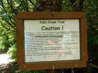
Length of Hike:  The Falls Creek Trail 2 Miles Round Trip
Parking areas: N42.86902 W76.17735

1- Blue Hole Falls Otisco Town
Private Property No Trespassing
This is not a part of Adam’s Camp Trail. You will see the trail and all the posted signs for this. It is not accessible and is on private property.
Falls: N42.86591 W76.17834, Height: 25 ft, Elevation: 1050 ft, Type: Ribbon Plunge Cascade

2- Bathtub Falls Otisco Town, Found information for this on their website
Falls: N42.86557 W76.17304, Elevation: 975 ft

3- Wedding Falls Otisco Town, Found information for this on their website
Falls: N42.86242 W76.16851, Elevation: 900 ft, Type: Tiered Cascade

4- Great Falls (Onondaga) Otisco Town, Found information for this on their website
Falls: N42.86157 W76.16627, Elevation: 825 ft, Type: Cascade

5- Rock Slide Falls Lafayette Town
Falls: N42.86041 W76.16217, Elevation: 775 ft, Type: Slide

6- Clay Slide Lafayette Town
Falls: N42.86041 W76.16217, Elevation: 750 ft, Type: Slide

7- Clay Slide Falls Lafayette Town
Falls: N42.85957 W76.15682, Elevation: 769 ft,Type: Slide

8- Mini Falls (Onondaga) Lafayette Town
Falls: N42.85919 W76.15333, Elevation: 698 ft


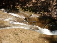
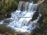
Photos from the Trail


Buckley Hollow – 3 Waterfalls

Buckley Hollow – 3 Waterfalls

Buckley Hollow – 3 Waterfalls

AKA:
—–
Location:
Smithville Twn
First Visit:
4/17/2016
Region:
Central
County:
Chenango
Park/Area:
—–
Gps of Falls:
—–
Gps of Parking:
N42.40109 W75.65945
Gps of Trailhead:
—–
Trail Name/Reference to:
—–
Landmark:
Finger Lakes Trail white blazed
Stream/River/Watershed:
Bowman Creek
Height of Falls/Type:
several small cascades, drops, ledges
Elevation:
1203-1040 ft
Level of Difficulty/Hiking Distance:
Currently this section of the Finger Lakes Trail is only open for the first 1/4 mile. Due to logging the rest is closed and the other end is open.
Wikiloc:
Whitewater Rte/Canoe Rte Map:
—–
Maps:
—–
Trails Websites:
—–
My Resource:
M25 Finger Lakes Trail Guide Maps
Book Resource:
—–
Brochures/Travel Guides/Visitor Guides:
—–
Additional Information:
Photos And Information I Contributed To or Posted To Other Websites:
Nearest Intersection:
Buckley Hollow Rd and Williams Rd
Directions:
From Hwy 12 and Hwy 206, in Greene, Get on Hwy 12 and drive northeast for 6.9 miles. Turn left onto Williams Rd and drive 1.8 miles.Turn left onto Buckley Hollow Rd, and park off to the side of the road.
Comments/Notes:
There is no technical real parking area for this location. Parking is anywhere safe at this “Y” intersection. Almost directly at the corner of Buckley Hollow Rd and Williams road is the Finger lakes trailhead. This trail goes thru private property, please stay on the trail. From the trail start, you will see a notice stating the trail is closed off in ¼ of a mile. As you leave the roadside you will come to a fence and a little ladder type thing in which you will use to climb over the wired fencing. Once over the fence the trail continues to the left along the edges of an open field. In about 400 ft you will entered the woods line again and will be following a well maintained trail. There is fence up all along the edge of the stream to your left. You cannot cross over this fence to get a closer view of the small falls along here. You have more of a birdseye view of this whole section. (To be honest this section is actually best viewed from walking along the roadside on Buckley Hollow road.) Continue along the trail and you will come to a section much similar to a bend in the road, here you have a good view of the bridge on Buckley hollow road. Continue along for about another 400 ft and you will come to the Second Main waterfall. Again these views are all birdseye to falls below. Here is where the trail is closed and you turn around and head back out the same way. If the trail was open there is the third waterfall. The trail continues all the way to Highway 12 entrance/exit of this section of the finger lakes trail.

For additional information please click on the following links
Buckley Hollow Falls #1
Buckley Hollow Falls #2
Buckley Hollow Falls #3

Wikiloc-Buckley Hollow Waterfalls (Bowman Creek)

Powered by Wikiloc

Chenango County, Bucks Brook State Forest, falls on

Bucks Brook – 2 Waterfalls and a Dam

Bucks Brook – 2 Waterfalls and a Dam

Bucks Brook – 2 Waterfalls and a Dam

AKA:
—–
Location:
Otselic Twn
First Visit:
4/17/2016
Region:
Central
County:
Chenango
Park/Area:
Gps of Falls:
—–
Gps of Parking:
N42.68418 W75.76543
Gps of Trailhead:
—–
Trail Name/Reference to:
—–
Landmark:
Finger Lakes Trail white blazed
Stream/River/Watershed:
Bucks Brook
Height of Falls/Type:
series of small waterfalls, ledges, cascades
Elevation:
1571-1343 ft
Level of Difficulty/Hiking Distance:
Roadside
Wikiloc:
—–
Whitewater Rte/Canoe Rte Map:
—–
Maps:
—–
Trails Websites:
—–
My Resource:
Book Resource:
—–
Brochures/Travel Guides/Visitor Guides:
—–
Additional Information:
—–
Photos And Information I Contributed To or Posted To Other Websites:
Nearest Intersection:
Bucks Brook Rd and and Valley View Rd
Directions:
From Hwy 80 and Hwy 26, in Ostelic Town, Get on Hwy 26 and drive south for 3.4 miles. Turn right onto Valley View Rd and in only a few hundred feet you will come to the intersection of Bucks Brook Rd and Valley View Rd.
Comments/Notes:
Starting at the intersection of Bucks Brook Road and Valley View Road, work your way up Bucks Brook Road, you will see the series of small ledges, cascades, small falls. I had recorded the gps locations for the biggest ones.

For additional information please click on the following links
Bucks Brook, falls on #1
Bucks Brook, falls on #2
Bucks Brook, small dam