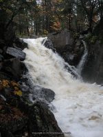
Jenny Creek Waterfalls on (7 Named Waterfalls)
Jenny Creek Waterfalls on (7 Named Waterfalls)
Whitewater Route Jenny Creek
St Lawrence County, Town of Pitcairn
Date Visited: 10/7/2010
Stream or River: Gulf Stream/Jenny Creek
Resources Used:
World Waterfall Database
American Whitewater
Directions:
From I-81 N in Theresa, Take exit 49 to the right onto Rt-411 towards Theresa/Lafargeville for .3 miles. Turn right onto Highway 411 and drive for 4.7 miles. Turn left onto Commercial Street and drive for .7 miles. Turn left onto Oxbow Road and drive for 9.6 miles. Turn right onto Cr-25 and drive for 8.8 miles. Turn left onto W Main Street and drive for .3 miles. Turn right onto William Street and drive for 6.1 miles. Turn right onto Highway 812 and drive for 9.5 miles. Turn left onto Pitcairn-Fowler Road and drive for 1.3 miles. Turn left onto Highway 3 and drive for 1.3 miles. Bear right onto Jayville Road and drive for 1.0 miles. The first falls is Jenny Creek Falls Lower. I have not been to this one yet. Continue on Jayville Road for 1.0 miles. This next one is Jenny Creek Falls. Continue on Jayville Road and drive for .6 miles to Jenny Creek Middle Falls. Continue on Jayville Road and drive for .2 miles, this brings you to the last one, Jenny Creek Upper Falls.
Trail Description: Described within
Comments:
Putting together this whole section of Jenny Creek was and still is a bit confusing so I will piece it together as best as possible. When I checked this location out back in 2010, I had only 2 locations with the coordinates for. And those I had gotten from the World Waterfall database. Since then I have gain more knowledge along with better technology. I recently found that the American Whitewater has a page on this section of Jenny Creek. By matching my photos up with theirs along with similar descriptions, I have been able to make some corrections.
The whitewater route starts at Powell Road, south of Hwy 3. When I was there you could not drive on Jayville road all the way, as you come to where the bridge is out. So I did not check out their first 1.3 miles of the route.
1-Mike’s Boof Class III-Gulf Stream
2-Railroad Slide Class III+-Gulf Stream
Beaver Pond/Dam Class I-Gulf Stream
3-This one here I had called Jenny Creek Upper Falls (Footbridge rapid Class III+)
Described as starting under a footbridge and ending behind a camp. Viewing from this is roadside only, private property.
Another Beaver Pond/Dam Class I-Jenny Creek
4-Now this one I had called Jenny Creek Middle Falls, but it falls in the location they called the Ugly Drop-Jenny Creek
You will see a huge rock and smaller rock on top, looks like a huge cairn, on the side of the road. It is a short scramble but the view was hard to get.
5-Middle Section Class IV-Jenny Creek
6-And this one I had called Jenny Creek Lower Falls, and again it falls within the location and photo match with what they called Jayville Rapid Class 5.0/Jayville Slide. This may also be known as Jenny Creek Falls. This is a roadside view.
7-Horrific– which is described as being 30-35 foot drop.-Jenny Creek
8-The Rest Class III they describe one more dangerous section which maybe what resources are calling Jenny Creek Lower Falls.


