Otter Creek Falls on: Eatonville Falls (7 Waterfalls)
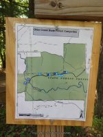
Otter Creek State Forest
Whitewater section on Otter Creek
Partridgeville Road to Pine Grove Road
Lewis County, Martinsburg Town
Named Waterfalls:
First Rapid IV aka Eatonville Falls,
Bridge Rapid (Class IV, Mile 0.1),
Boof III (Class III, Mile 0.3),
Ledges III (Class III, Mile 0.8),
Birdbath III (Class III+, Mile 1.0),
Eagles Talon 5.1 (Class 5.1, Mile 1.2),
Crumbly Dam (Class IV+, Mile 1.8)
I have recorded the tracks for the trail section near the bridge. This can be viewed and downloaded, click on the following link.
Wikiloc Otter Creek Falls
Date Visited: 6/7/2015
We did not see all the falls for this location and plan to go back.
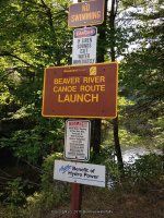
Stream or River: Otter Creek flows into the Black River
Resources Used:
Eastern New York All Outdoors Atlas And Field Guide Publication 2008 pg 107 E4
Otter Creek – Partridgeville Road to Pine Grove Rd.
http://www.adirondackstughill.com/index.php/site/attractions/waterfalls
Directions to Eatonville Camping and Picnic area:
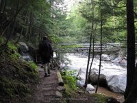
From the town of Greig at the intersection of Blue Street (Main Street name changes to Blue Street) and Greig Road drive southeast on Greig Road for about 1.4 miles. Bear left onto Odett Road and drive .3 miles to Pine Grove Road. Turn left again, then a right onto Eatonville Road. Drive 1.4 miles on Eatonville Road, which changes to Otter Creek Truck Trail. Drive over the bridge to the parking area. The falls are located upstream and downstream from the bridge. A short trail is on both sides of the creek.
Directions to Take Out Location:
From the town of Greig at the intersection of Blue Street (Main Street name changes to Blue Street) and Greig Road drive southeast on Greig Road for about .5 miles. Turn left onto Otter Creek Road and drive about 1.5 miles. Turn left here onto Pine Grove Road and drive about .1 mile. Turn right here onto Chases Lake Road. There is a take out near the dam for the kayak-canoe route.
Parking Areas:
Eatonville Road
N43.71461 W75.34312 942 ft
Chases Lake Road
N43.71930 W75.36558 796 ft
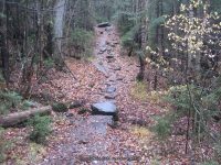
Trail Description:
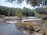
From the bridge looking upstream you can see the main falls from the bridge. There are trails on both sides of the creek both upstream and downstream. For upstream, we took the left side trail, and for downstream the right side trail, which is very easy.
.1 mile upstream and back
.2 miles total downstream and back
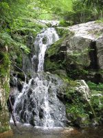
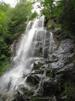
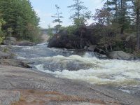
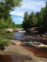
First Rapid IV aka Eatonville Falls
Closest Intersection: Eatonville Road And Van Arnam Road
Location: N43.71350 W75.34201
Height: 15 ft to 20 ft
Elevation: 950 ft
Type: Class IV Rapid Slide Steps
Hike: Short
Photo Location:
N43.71401 W75.34241
N43.71451 W75.34314
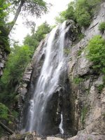
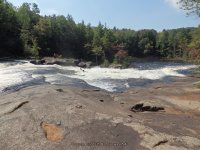
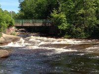
Bridge Rapid IV On Otter Creek
Closest Intersection: Eatonville Road And Van Arnam Road
Location: N43.71446 W75.34336
Height: 4 ft
Elevation: 925 ft
Type: Slide Class IV
Hike: Roadside
Photo Location:
N43.71460 W75.34334
N43.71481 W75.34397
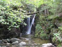
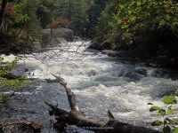
Boof III (Class III, Mile 0.3)
Closest Intersection: Eatonville Road And Van Arnam Road
Location: N43.72010 W75.34459
Height: 1 ft to 2 ft
Elevation: 909 ft
Type: Drop
Hike: .3 mile from the Eatonville bridge located at the small campground and picnic area on Eatonville Road
Photo Location:
N43.71522 W75.34425
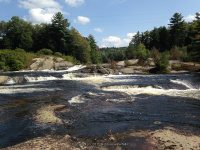
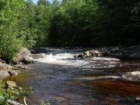
Ledges III (Class III, Mile 0.8)
Closest Intersection: Eatonville Road And Van Arnam Road
Location: N43.72355 W75.34748
Height 5 ft
Elevation 900 ft
Type: Ledges
Hike: .8 mile from the Eatonville bridge located at the small campground and picnic area on Eatonville Road.
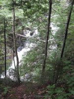
Birdbath III (Class III+, Mile 1.0)
Closest Intersection: Chases Lake Road And Pine Grove Road
Location: N43.72391 W75.35282
Height: 15 ft To 20 ft
Elevation: 874 ft
Type: Slide Flume
Hike: 1 mile from the Eatonville bridge located at the small campground and picnic area on Eatonville Road
Eagles Talon 5.1 (Class 5.1, Mile 1.2)
Closest Intersection: Chases Lake Road And Pine Grove Road
Location: N43.72421 W75.35998
Height:
Elevation: 818 ft
Type: Class 5.1 Rapids
Hike: 1.2 mile from the Eatonville bridge located at the small campground and picnic area on Eatonville Road.
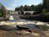
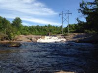
Crumbly Dam IV (Class IV+, Mile 1.8)
Closest Intersection: Chases Lake Road And Pine Grove Road
Location: N43.71885 W75.36449
Height: 8 ft To 10 ft
Elevation: 783 ft
Type: Dam Slide Ledges
Hike: 1.8 mile from the Eatonville bridge located at the small campground and picnic area on Eatonville Road.
Otter Creek Falls On (Partridgeville Road) Greig Town
Closest Intersection: Partridgeville Road And 10 Mile Truck Trail
Location: N43.72602 W75.17355
Elevation: 1525 ft
Hike: Roadside
From the intersection of Highway 12 and Burdicks Crossing Road going south from the town of Greig, turn left onto Burdicks Crossing Road and drive 1.4 miles to the intersection with Greig Road. Turn left onto Greig Road and drive .7 miles and turn right onto Brantingham Road. Drive on Brantingham Road for 3.6 miles. You will now be in the little town of Brantingham. Turn left onto Partridgeville Road, which is a dirt road. Drive about 7.5 miles to its end. The small falls are right there on your right at the turn around.
| Original content here is published under these license terms: | X |
|
| License Type: | General Public License | |
|
| License Abstract: | The GNU General Public License is a free, copyleft license for software and other kinds of works. You may re-publish the content (modified or unmodified) providing the re-publication is itself under the terms of the GPL. |
|
| License URL: | http://www.gnu.org/licenses/gpl.html |
Like this:
Like Loading...