
Twitchell Creek Falls and Cascades
Twitchell Creek Falls and Cascades
AKA: |
—– |
Location: |
Webb Twn |
First Visit: |
6/27/2016 |
Region: |
Central |
County: |
Herkimer |
Park/Area: |
—– |
Gps of Falls: |
N43.83756 W74.89447 |
Gps of Parking: |
N43.84081 W74.89351 |
Gps of Trailhead: |
—– |
Trail Name/Reference to: |
—– |
Landmark: |
Twitchell Lake |
Stream/River/Watershed: |
Twitchell Creek |
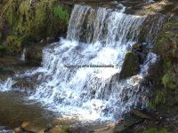
Height of Falls/Type: |
total 100 ft spanned over 1/3 mile, several small cascades and 1 large cascade |
Elevation: |
2079 ft |
Level of Difficulty/Hiking Distance: |
.3 miles walking back down the road from the parking area brings you to the trail. Look for a faint pink double ribbon on a tree. It then is a couple hundred feet to the top of the large falls. |
Wikiloc: |
|
Whitewater Rte/Canoe Rte Map: |
—– |
Maps: |
—– |
Trails Websites: |
—– |
My Resource: |
Discover the Central Adirondacks, Four-Season Adventures in the Heart of the Northwoods, 4th Edition 2007, Barbara McMartin & Bill Ingersoll |
Book Resource: |
Discover the Central Adirondacks, Four-Season Adventures in the Heart of the Northwoods, 4th Edition 2007, Barbara McMartin & Bill Ingersoll |
Brochures/Travel Guides/Visitor Guides: |
—– |
Additional Information: |
—– |
Photos And Information I Contributed To or Posted To Other Websites: |
Digthefalls |
Nearest Intersection: |
Twitchell Inn Rd and Pond Trl |
Directions: |
From County Rte 28 and Big Moose Rd, in Eagle Bay, Get on Big Moose Rd and drive north for 5.8 miles. Turn left onto Big Moose Rd and drive for 1.7 miles. Turn right onto Twitchell Rd and drive 2.1 miles to parking area. |
Comments/Notes: |
As you are walking down the road you will see several small cascades and some can be seen from the road. A short scramble/bushwhack will lead you to another waterfall here N43.83862 W74.89346 Please use caution in this area. Not a good location for children. For the main waterfall, the trail is easy and short. You can continue on the trail to the base of the waterfall. It is steep in some spots, and close to the edge of the waterfall. |
For further information on this area, please click on the following links:
Twitchell Creek Falls and Cascades #1 bridge falls
Twitchell Creek Falls and Cascades #2
Twitchell Creek Falls and Cascades #3
Twitchell Creek Falls and Cascades #4 Main Falls
Twitchell Creek Falls and Cascades
Powered by Wikiloc


 MADISON COUNTY CENTRAL NEW YORK 4-6-2014_00001.JPG")


