Category Archives: Parks

Shurform falls

Shurform falls

Shurform falls

Taylorville Whitewater Section Lewis County, NY 9/7/2015

Taylorville Whitewater Section Lewis County, NY 9/7/2015

Taylorville Whitewater Section Lewis County, NY 9/7/2015
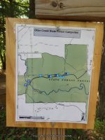
The map below shows a good portion of the route that I had tracked.

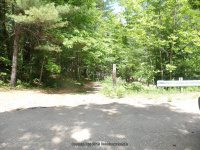
This is where we parked, which was the start point of the tracking. (Note: We did not go to the end of Double Eddy Road to park, as there was no room to park at the time) From there we took the trail which comes out to the bottom of the second falls.

Parking

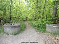
Above alternate parking

Trail

Above is the trail

When we got to the end of the trail we wanted to start from the put in at the first dam. The trail length is less then .1 mile.

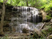
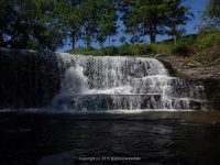
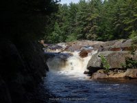
Taylorville Dam aka Taylorville Falls

IMG_3688

Above the Put In

IMG_3689

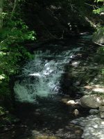
(Above) Looking downstream from the small walk bridge at the Put In

OLYMPUS DIGITAL CAMERA

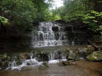
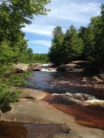
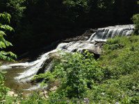
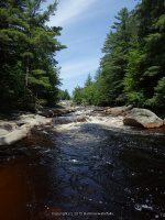
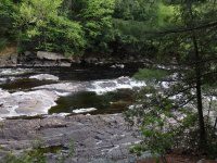
This is the second dam. Taylorville Lower Falls

IMG_3701

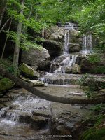
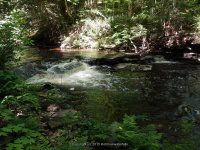
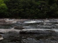
The 2 dams combine and flow into a section called the Beaverator IV-Rapids

OLYMPUS DIGITAL CAMERA

OLYMPUS DIGITAL CAMERA

OLYMPUS DIGITAL CAMERA

In the photo above I tried capturing one of the guys coming thru, the next guy went under but came out okay.

OLYMPUS DIGITAL CAMERA

Above shows the section to the right of the second dam, viewed from the main trail.

Approaching the top of the Great White Slide Section

(Above) We are approaching the top of the Great White Slide Section. The following photos are of the Great White Slide area.

OLYMPUS DIGITAL CAMERA

OLYMPUS DIGITAL CAMERA

OLYMPUS DIGITAL CAMERA

OLYMPUS DIGITAL CAMERA


The following photos were taken down along the trail to where there was a picnic table. Note: In the photo above, where the tree line is at back end of photo is where the picnic area is.) Just continue down the trail from the bottom of the Great White Slide.

OLYMPUS DIGITAL CAMERA

IMG_3716

OLYMPUS DIGITAL CAMERA

OLYMPUS DIGITAL CAMERA

(Above) This is the trail viewed from the picnic area.

IMG_3722

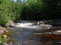
The next set of photos are taken at the picnic area. This section I believe is the Dogleg III Rapids and Mindscrambler III Rapids section. I took photos from the top, and then we walked around further down to get some lower views.

OLYMPUS DIGITAL CAMERA

OLYMPUS DIGITAL CAMERA

OLYMPUS DIGITAL CAMERA

OLYMPUS DIGITAL CAMERA

OLYMPUS DIGITAL CAMERA

OLYMPUS DIGITAL CAMERA

OLYMPUS DIGITAL CAMERA

It was at this point we back tracked and went to our vehicle and drove down to the take out on Taylorville Road. Which is at the power plant. Silly me also thought I was still tracking, BUT did not turn it back on, so I will do my best to detail.

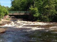
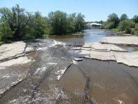
To view the Take Out section, and to view the Powerline Boof IV Rapids Section from the bottom. From the parking area you will walk through the gate and continue straight ahead following the small path to the river.

This is on your right before going through the gate. You will have the power plant on your left, the river straight ahead and then if you go right before the fence line the short graveled road leads to the canoe boat launch area.

(Above) This is on your right before going through the gate. You will have the power plant on your left, the river straight ahead and then if you go right before the fence line the short graveled road leads to the canoe boat launch area.

IMG_3557

The next set of photos are taken at the Take Out site.

IMG_3739

IMG_3741

OLYMPUS DIGITAL CAMERA

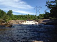
The next set of photos are also taken from the Take Out section looking upstream towards Powerline Boof IV Rapids Section.

IMG_3732

OLYMPUS DIGITAL CAMERA

From here we back tracked back towards the parking area. When you reach the gate, turn and walk right along the fence line and follow the penstock a short distance. You will see a small path that leads again back to the river. The following photo is a visual from where I was standing at the trail that leads down to the river, and I am looking back up towards the parking area.

OLYMPUS DIGITAL CAMERA

These photos are of the Powerline Boof IV Rapids Section

IMG_3763 IMG_3766 IMG_3792 OLYMPUS DIGITAL CAMERA


To explore this whole section from start to finish took us about 2 1/2 hours. For actual walking distance in both areas maybe about 1 1/2 miles.

Three Falls Woods, Onondaga County, New York

Three Falls Woods, Onondaga County, New York

Three Falls Woods, Onondaga County, New York

Three Falls Woods contains three separate waterfalls. The most direct trail to the base of the waterfalls is approximate 1.6 miles round trip.

The Falls from left to right is Staircase Falls, Tall Twin Falls and then Cascade Falls.

To see the tracks for the trail on Wikiloc for Filmore Corners-Three Falls Woods

For additional information on these waterfalls go to Three Falls Woods, or the individual links above.

The next few sets of photos were taking on the trail at the top and above the three main falls.

Three Falls Woods-Fillmore Corners

Three Falls Woods-Fillmore Corners

Three Falls Woods-Fillmore Corners
Onondaga County, Manlius Town, New York

Wikiloc-Three Falls Woods-Fillmore Corners

Powered by Wikiloc

Stream or River: Limestone Creek Tributaries To Chittenango Creek

Dates Visited:
6/14/2015

Maps and Resources used to gather information:

Western New York all outdoors Atlas & Field Guide Publication 2008 135 E5
World Waterfalls Database

Directions: From the intersection of Highway 173 and Highway 92 in manlius, take Highway 173 southwest for .8 miles. Turn right onto Glencliffe Road and drive .5 miles to a parking area on the right just before the curve.

Length of Hike:  Approximate 1.6 miles round trip on the direct trail to the base of the falls.

 
Parking areas: N42.99742 W75.99968
 
From the parking area you will enter the trail to the left. Take the trail to the left. Walk about .3 miles and you will come to another trail intersection. Go left here. You will go down a little hill to the stream bed. Follow the stream. You will quickly come to what is left of a dam, which is now very colorful with graffiti. Continue on from here for another .4 miles to the base of the falls. Between the dam and the falls you will have passed by a campsite. If only people would pick up their garbage!! This is not what appears to be a true campsite but more of a party place. We chose to do the loop, and took the trail that goes along the top of the cliff to the top of the falls. Use caution, as you get closer to the top the trail gets closer to the edge. The trail becomes more of a path then a trail, walking on rocks or boulders as some would say. When you get to the top, there are paths to get you down to the base of the falls. Use caution, as this can be dangerous with rain and snow or ice. From the base looking at the three waterfalls from left to right is Staircase Falls, in the middle is Tall Twin Falls and then Cascade Falls.

Tall Twin Falls In Three Falls Woods

Falls: N42.99202 W76.01186
Landmark:
Height:70 ft
Elevation: 720 ft

Type:Cascade

Home » Three Falls Woods-Fillmore Corners » TALL TWIN FALLS in THREE FALLS WOODS

TALL TWIN FALLS in THREE FALLS WOODS

TALL TWIN FALLS ONONADAGA 6-14-2015_00001.JPG
TALL TWIN FALLS ONONADAGA 6-14-2015_00001.JPG (Bobbie Sweeting)
Share on Twitter
Share on Pinterest
TALL TWIN FALLS ONONADAGA 6-14-2015_00002.JPG
TALL TWIN FALLS ONONADAGA 6-14-2015_00002.JPG (Bobbie Sweeting)
Share on Twitter
Share on Pinterest
TALL TWIN FALLS ONONADAGA 6-14-2015_00003.JPG
TALL TWIN FALLS ONONADAGA 6-14-2015_00003.JPG (Bobbie Sweeting)
Share on Twitter
Share on Pinterest
TALL TWIN FALLS ONONADAGA 6-14-2015_00004.JPG
TALL TWIN FALLS ONONADAGA 6-14-2015_00004.JPG (Bobbie Sweeting)
Share on Twitter
Share on Pinterest
TALL TWIN FALLS ONONADAGA 6-14-2015_00005.JPG
TALL TWIN FALLS ONONADAGA 6-14-2015_00005.JPG (Bobbie Sweeting)
Share on Twitter
Share on Pinterest
TALL TWIN FALLS ONONADAGA 6-14-2015_00006.JPG
TALL TWIN FALLS ONONADAGA 6-14-2015_00006.JPG (Bobbie Sweeting)
Share on Twitter
Share on Pinterest
TALL TWIN FALLS ONONADAGA 6-14-2015_00007.JPG
TALL TWIN FALLS ONONADAGA 6-14-2015_00007.JPG (Bobbie Sweeting)
Share on Twitter
Share on Pinterest
TALL TWIN FALLS ONONADAGA 6-14-2015_00008.JPG
TALL TWIN FALLS ONONADAGA 6-14-2015_00008.JPG (Bobbie Sweeting)
Share on Twitter
Share on Pinterest
TALL TWIN FALLS ONONADAGA 6-14-2015_00009.JPG
TALL TWIN FALLS ONONADAGA 6-14-2015_00009.JPG (Bobbie Sweeting)
Share on Twitter
Share on Pinterest
TALL TWIN FALLS ONONADAGA 6-14-2015_00010.JPG
TALL TWIN FALLS ONONADAGA 6-14-2015_00010.JPG (Bobbie Sweeting)
Share on Twitter
Share on Pinterest
TALL TWIN FALLS ONONADAGA 6-14-2015_00011.JPG
TALL TWIN FALLS ONONADAGA 6-14-2015_00011.JPG (Bobbie Sweeting)
Share on Twitter
Share on Pinterest
TALL TWIN FALLS ONONADAGA 6-14-2015_00012.JPG
TALL TWIN FALLS ONONADAGA 6-14-2015_00012.JPG (Bobbie Sweeting)
Share on Twitter
Share on Pinterest
TALL TWIN FALLS ONONADAGA 6-14-2015_00013.JPG
TALL TWIN FALLS ONONADAGA 6-14-2015_00013.JPG (Bobbie Sweeting)
Share on Twitter
Share on Pinterest
TALL TWIN FALLS ONONADAGA 6-14-2015_00014.JPG
TALL TWIN FALLS ONONADAGA 6-14-2015_00014.JPG (Bobbie Sweeting)
Share on Twitter
Share on Pinterest
TALL TWIN FALLS in THREE FALLS WOODS, ONONADAGA COUNTY, NEW YORK 6-14-2015

 
Staircase Falls In Three Falls Woods
At the very top and near the road we captured this section of falls. It appears this is or could be Upper Staircase Falls. N42.99158 W76.01181
Falls: N42.99182 W76.01180
Landmark:
Height: 70 ft
Elevation: 706 ft

Type: Staircase Cascade

Home » Three Falls Woods-Fillmore Corners » STAIRCASE FALLS in THREE FALLS WOODS

STAIRCASE FALLS in THREE FALLS WOODS

STAIRCASE FALLS ONONADAGA 6-14-2015_00001.JPG
STAIRCASE FALLS ONONADAGA 6-14-2015_00001.JPG (Bobbie Sweeting)
Share on Twitter
Share on Pinterest
STAIRCASE FALLS ONONADAGA 6-14-2015_00002.JPG
STAIRCASE FALLS ONONADAGA 6-14-2015_00002.JPG (Bobbie Sweeting)
Share on Twitter
Share on Pinterest
STAIRCASE FALLS ONONADAGA 6-14-2015_00003.JPG
STAIRCASE FALLS ONONADAGA 6-14-2015_00003.JPG (Bobbie Sweeting)
Share on Twitter
Share on Pinterest
STAIRCASE FALLS ONONADAGA 6-14-2015_00004.JPG
STAIRCASE FALLS ONONADAGA 6-14-2015_00004.JPG (Bobbie Sweeting)
Share on Twitter
Share on Pinterest
STAIRCASE FALLS ONONADAGA 6-14-2015_00005.JPG
STAIRCASE FALLS ONONADAGA 6-14-2015_00005.JPG (Bobbie Sweeting)
Share on Twitter
Share on Pinterest
STAIRCASE FALLS ONONADAGA 6-14-2015_00006.JPG
STAIRCASE FALLS ONONADAGA 6-14-2015_00006.JPG (Bobbie Sweeting)
Share on Twitter
Share on Pinterest
STAIRCASE FALLS ONONADAGA 6-14-2015_00007.JPG
STAIRCASE FALLS ONONADAGA 6-14-2015_00007.JPG (Bobbie Sweeting)
Share on Twitter
Share on Pinterest
STAIRCASE FALLS ONONADAGA 6-14-2015_00008.JPG
STAIRCASE FALLS ONONADAGA 6-14-2015_00008.JPG (Bobbie Sweeting)
Share on Twitter
Share on Pinterest
STAIRCASE FALLS ONONADAGA 6-14-2015_00009.JPG
STAIRCASE FALLS ONONADAGA 6-14-2015_00009.JPG (Bobbie Sweeting)
Share on Twitter
Share on Pinterest
STAIRCASE FALLS ONONADAGA 6-14-2015_00010.JPG
STAIRCASE FALLS ONONADAGA 6-14-2015_00010.JPG (Bobbie Sweeting)
Share on Twitter
Share on Pinterest
STAIRCASE FALLS ONONADAGA 6-14-2015_00011.JPG
STAIRCASE FALLS ONONADAGA 6-14-2015_00011.JPG (Bobbie Sweeting)
Share on Twitter
Share on Pinterest
STAIRCASE FALLS ONONADAGA 6-14-2015_00012.JPG
STAIRCASE FALLS ONONADAGA 6-14-2015_00012.JPG (Bobbie Sweeting)
Share on Twitter
Share on Pinterest
STAIRCASE FALLS ONONADAGA 6-14-2015_00013.JPG
STAIRCASE FALLS ONONADAGA 6-14-2015_00013.JPG (Bobbie Sweeting)
Share on Twitter
Share on Pinterest
STAIRCASE FALLS in THREE FALLS WOODS, ONONADAGA COUNTY, NEW YORK 6-14-2015

 
Home » Three Falls Woods-Fillmore Corners » SECOND FALLS AT THE TOP in THREE FALLS WOODS

SECOND FALLS AT THE TOP in THREE FALLS WOODS

SECOND FALLS AT THE TOP ONONADAGA 6-15-2015_00001.JPG
SECOND FALLS AT THE TOP ONONADAGA 6-15-2015_00001.JPG (Bobbie Sweeting)
Share on Twitter
Share on Pinterest
SECOND FALLS AT THE TOP ONONADAGA 6-15-2015_00002.JPG
SECOND FALLS AT THE TOP ONONADAGA 6-15-2015_00002.JPG (Bobbie Sweeting)
Share on Twitter
Share on Pinterest
SECOND FALLS AT THE TOP ONONADAGA 6-15-2015_00003.JPG
SECOND FALLS AT THE TOP ONONADAGA 6-15-2015_00003.JPG (Bobbie Sweeting)
Share on Twitter
Share on Pinterest
SECOND FALLS AT THE TOP ONONADAGA 6-15-2015_00004.JPG
SECOND FALLS AT THE TOP ONONADAGA 6-15-2015_00004.JPG (Bobbie Sweeting)
Share on Twitter
Share on Pinterest
SECOND FALLS AT THE TOP ONONADAGA 6-15-2015_00005.JPG
SECOND FALLS AT THE TOP ONONADAGA 6-15-2015_00005.JPG (Bobbie Sweeting)
Share on Twitter
Share on Pinterest
SECOND FALLS AT THE TOP ONONADAGA 6-15-2015_00006.JPG
SECOND FALLS AT THE TOP ONONADAGA 6-15-2015_00006.JPG (Bobbie Sweeting)
Share on Twitter
Share on Pinterest
SECOND FALLS AT THE TOP ONONADAGA 6-15-2015_00007.JPG
SECOND FALLS AT THE TOP ONONADAGA 6-15-2015_00007.JPG (Bobbie Sweeting)
Share on Twitter
Share on Pinterest
SECOND FALLS AT THE TOP ONONADAGA 6-15-2015_00008.JPG
SECOND FALLS AT THE TOP ONONADAGA 6-15-2015_00008.JPG (Bobbie Sweeting)
Share on Twitter
Share on Pinterest
SECOND FALLS AT THE TOP in THREE FALLS WOODS, ONONADAGA COUNTY, NEW YORK 6-14-2015


Cascade Falls In Three Falls Woods

At the very top almost to the road above we captured the section of falls. It appears this is or could be Upper Cascade Falls. N42.99183 W76.01300
Falls: N42.99209 W76.01224
Landmark:
Height: 70 ft
Elevation: 705 ft

Type: Cascade

Home » Three Falls Woods-Fillmore Corners » CASCADE FALLS in THREE FALLS WOODS

CASCADE FALLS in THREE FALLS WOODS

CASCADE FALLS ONONADAGA 6-14-2015_00001.JPG
CASCADE FALLS ONONADAGA 6-14-2015_00001.JPG (Bobbie Sweeting)
Share on Twitter
Share on Pinterest
CASCADE FALLS ONONADAGA 6-14-2015_00002.JPG
CASCADE FALLS ONONADAGA 6-14-2015_00002.JPG (Bobbie Sweeting)
Share on Twitter
Share on Pinterest
CASCADE FALLS ONONADAGA 6-14-2015_00003.JPG
CASCADE FALLS ONONADAGA 6-14-2015_00003.JPG (Bobbie Sweeting)
Share on Twitter
Share on Pinterest
CASCADE FALLS ONONADAGA 6-14-2015_00004.JPG
CASCADE FALLS ONONADAGA 6-14-2015_00004.JPG (Bobbie Sweeting)
Share on Twitter
Share on Pinterest
CASCADE FALLS ONONADAGA 6-14-2015_00005.JPG
CASCADE FALLS ONONADAGA 6-14-2015_00005.JPG (Bobbie Sweeting)
Share on Twitter
Share on Pinterest
CASCADE FALLS ONONADAGA 6-14-2015_00006.JPG
CASCADE FALLS ONONADAGA 6-14-2015_00006.JPG (Bobbie Sweeting)
Share on Twitter
Share on Pinterest
CASCADE FALLS ONONADAGA 6-14-2015_00007.JPG
CASCADE FALLS ONONADAGA 6-14-2015_00007.JPG (Bobbie Sweeting)
Share on Twitter
Share on Pinterest
CASCADE FALLS ONONADAGA 6-14-2015_00008.JPG
CASCADE FALLS ONONADAGA 6-14-2015_00008.JPG (Bobbie Sweeting)
Share on Twitter
Share on Pinterest
CASCADE FALLS in THREE FALLS WOODS, ONONADAGA COUNTY, NEW YORK 6-14-2015

 
Home » Three Falls Woods-Fillmore Corners » FIRST FALLS AT THE TOP in THREE FALLS WOODS

FIRST FALLS AT THE TOP in THREE FALLS WOODS

FIRST FALLS AT THE TOP ONONADAGA 6-15-2015_00001.JPG
FIRST FALLS AT THE TOP ONONADAGA 6-15-2015_00001.JPG (Bobbie Sweeting)
Share on Twitter
Share on Pinterest
FIRST FALLS AT THE TOP ONONADAGA 6-15-2015_00002.JPG
FIRST FALLS AT THE TOP ONONADAGA 6-15-2015_00002.JPG (Bobbie Sweeting)
Share on Twitter
Share on Pinterest
FIRST FALLS AT THE TOP ONONADAGA 6-15-2015_00003.JPG
FIRST FALLS AT THE TOP ONONADAGA 6-15-2015_00003.JPG (Bobbie Sweeting)
Share on Twitter
Share on Pinterest
FIRST FALLS AT THE TOP ONONADAGA 6-15-2015_00004.JPG
FIRST FALLS AT THE TOP ONONADAGA 6-15-2015_00004.JPG (Bobbie Sweeting)
Share on Twitter
Share on Pinterest
FIRST FALLS AT THE TOP ONONADAGA 6-15-2015_00005.JPG
FIRST FALLS AT THE TOP ONONADAGA 6-15-2015_00005.JPG (Bobbie Sweeting)
Share on Twitter
Share on Pinterest
FIRST FALLS AT THE TOP ONONADAGA 6-15-2015_00006.JPG
FIRST FALLS AT THE TOP ONONADAGA 6-15-2015_00006.JPG (Bobbie Sweeting)
Share on Twitter
Share on Pinterest
FIRST FALLS AT THE TOP ONONADAGA 6-15-2015_00007.JPG
FIRST FALLS AT THE TOP ONONADAGA 6-15-2015_00007.JPG (Bobbie Sweeting)
Share on Twitter
Share on Pinterest
FIRST FALLS AT THE TOP ONONADAGA 6-15-2015_00008.JPG
FIRST FALLS AT THE TOP ONONADAGA 6-15-2015_00008.JPG (Bobbie Sweeting)
Share on Twitter
Share on Pinterest
FIRST FALLS AT THE TOP in THREE FALLS WOODS, ONONADAGA COUNTY, NEW YORK 6-14-2015

Photos of the Trail and more photos from the Top
 
Home » Three Falls Woods-Fillmore Corners » THREE FALLS WOODS TRAIL

THREE FALLS WOODS TRAIL

THREE FALLS WOODS TRAIL ONONADAGA 6-14-2015_00001.JPG
THREE FALLS WOODS TRAIL ONONADAGA 6-14-2015_00001.JPG (Bobbie Sweeting)
Share on Twitter
Share on Pinterest
THREE FALLS WOODS TRAIL ONONADAGA 6-14-2015_00002.JPG
THREE FALLS WOODS TRAIL ONONADAGA 6-14-2015_00002.JPG (Bobbie Sweeting)
Share on Twitter
Share on Pinterest
THREE FALLS WOODS TRAIL ONONADAGA 6-14-2015_00003.JPG
THREE FALLS WOODS TRAIL ONONADAGA 6-14-2015_00003.JPG (Bobbie Sweeting)
Share on Twitter
Share on Pinterest
THREE FALLS WOODS TRAIL ONONADAGA 6-14-2015_00004.JPG
THREE FALLS WOODS TRAIL ONONADAGA 6-14-2015_00004.JPG (Bobbie Sweeting)
Share on Twitter
Share on Pinterest
THREE FALLS WOODS TRAIL ONONADAGA 6-14-2015_00005.JPG
THREE FALLS WOODS TRAIL ONONADAGA 6-14-2015_00005.JPG (Bobbie Sweeting)
Share on Twitter
Share on Pinterest
THREE FALLS WOODS TRAIL ONONADAGA 6-14-2015_00006.JPG
THREE FALLS WOODS TRAIL ONONADAGA 6-14-2015_00006.JPG (Bobbie Sweeting)
Share on Twitter
Share on Pinterest
THREE FALLS WOODS TRAIL ONONADAGA 6-14-2015_00007.JPG
THREE FALLS WOODS TRAIL ONONADAGA 6-14-2015_00007.JPG (Bobbie Sweeting)
Share on Twitter
Share on Pinterest
THREE FALLS WOODS TRAIL ONONADAGA 6-14-2015_00008.JPG
THREE FALLS WOODS TRAIL ONONADAGA 6-14-2015_00008.JPG (Bobbie Sweeting)
Share on Twitter
Share on Pinterest
THREE FALLS WOODS TRAIL ONONADAGA 6-14-2015_00009.JPG
THREE FALLS WOODS TRAIL ONONADAGA 6-14-2015_00009.JPG (Bobbie Sweeting)
Share on Twitter
Share on Pinterest
THREE FALLS WOODS TRAIL ONONADAGA 6-14-2015_00010.JPG
THREE FALLS WOODS TRAIL ONONADAGA 6-14-2015_00010.JPG (Bobbie Sweeting)
Share on Twitter
Share on Pinterest
THREE FALLS WOODS TRAIL, ONONADAGA COUNTY, NEW YORK 6-14-2015

 
Home » Three Falls Woods-Fillmore Corners » LOOKING DOWN OVER THE THREE FALLS in THREE FALLS WOODS

LOOKING DOWN OVER THE THREE FALLS in THREE FALLS WOODS

LOOKING DOWN OVER THE THREE FALLS 6-15-2015_00001.JPG
LOOKING DOWN OVER THE THREE FALLS 6-15-2015_00001.JPG (Bobbie Sweeting)
Share on Twitter
Share on Pinterest
LOOKING DOWN OVER THE THREE FALLS 6-15-2015_00002.JPG
LOOKING DOWN OVER THE THREE FALLS 6-15-2015_00002.JPG (Bobbie Sweeting)
Share on Twitter
Share on Pinterest
LOOKING DOWN OVER THE THREE FALLS 6-15-2015_00003.JPG
LOOKING DOWN OVER THE THREE FALLS 6-15-2015_00003.JPG (Bobbie Sweeting)
Share on Twitter
Share on Pinterest
LOOKING DOWN OVER THE THREE FALLS 6-15-2015_00004.JPG
LOOKING DOWN OVER THE THREE FALLS 6-15-2015_00004.JPG (Bobbie Sweeting)
Share on Twitter
Share on Pinterest
LOOKING DOWN OVER THE THREE FALLS 6-15-2015_00005.JPG
LOOKING DOWN OVER THE THREE FALLS 6-15-2015_00005.JPG (Bobbie Sweeting)
Share on Twitter
Share on Pinterest
LOOKING DOWN OVER THE THREE FALLS 6-15-2015_00006.JPG
LOOKING DOWN OVER THE THREE FALLS 6-15-2015_00006.JPG (Bobbie Sweeting)
Share on Twitter
Share on Pinterest
LOOKING DOWN OVER THE THREE FALLS 6-15-2015_00007.JPG
LOOKING DOWN OVER THE THREE FALLS 6-15-2015_00007.JPG (Bobbie Sweeting)
Share on Twitter
Share on Pinterest
LOOKING DOWN OVER THE THREE FALLS 6-15-2015_00008.JPG
LOOKING DOWN OVER THE THREE FALLS 6-15-2015_00008.JPG (Bobbie Sweeting)
Share on Twitter
Share on Pinterest
LOOKING DOWN OVER THE THREE FALLS 6-15-2015_00009.JPG
LOOKING DOWN OVER THE THREE FALLS 6-15-2015_00009.JPG (Bobbie Sweeting)
Share on Twitter
Share on Pinterest
LOOKING DOWN OVER THE THREE FALLS 6-15-2015_00010.JPG
LOOKING DOWN OVER THE THREE FALLS 6-15-2015_00010.JPG (Bobbie Sweeting)
Share on Twitter
Share on Pinterest
LOOKING DOWN OVER THE THREE FALLS in THREE FALLS WOODS, ONONADAGA COUNTY, NEW YORK 6-14-2015

Eatonville Falls, Lewis County Waterfall Trip on 6-7-2015 part 3

Eatonville Falls, Lewis County Waterfall Trip on 6-7-2015 part 3

Eatonville Falls, Lewis County Waterfall Trip on 6-7-2015 part 3

From the town of greig at the intersect of blue street (main street name changes to blue street) and greig road drive southeast on greig road for about 1.4 Miles. Bear left onto odett road and drive .3 Miles to pine grove road. Turn left again then a right onto eatonville road. Drive 1.4 Miles on eatonville road which changes to otter creek truck trail. Drive over the bridge to the parking area.

Small campground and picnic area, no restrooms! There are trails on both sides going upstream. I only took the trail on the right going downstream. The trails are very easy.

American Whitewater Rafting Route Otter Creek: Partridgeville road to Pine Grove Road

Tracks for Eatonville Falls on the Otter Creek Trail location on Wikiloc

EATONVILLE FALLS MAY BE NAMED THE FIRST RAPID ON THE WHITEWATER ROUTE FOR THIS SECTION.

EATONVILLE FALLS on OTTER CREEK

FIRST RAPID IV on OTTER CREEK

BRIDGE RAPID IV on OTTER CREEK

THIS LAST SECTION IS LOCATED A SHORT DISTANCE DOWN BELOW THE BRIDGE

Lewis County Waterfall Trip on 6-7-2015 part 2

Lewis County Waterfall Trip on 6-7-2015 part 2

This is a roadside waterfall, most likely best seen in the spring or fall.

MARTINSBURG FALLS

This next set of photos were taken at different areas along Gomer Hill Road. We had meant to be on the next road over. Good thing! All of it are roadside views only.

MILL CREEK falls on (GOMER HILL ROAD)

This next one is not really considered a fall, and currently I find no name for it. Roadside only from the bridge.

MILL CREEK (SILVER CREEK) falls on (CEMETERY ROAD)

BOTH MOORES FALLS AND SILVER CREEK FALLS ARE LOCATED ON PRIVATE PROPERTY. THE HOME OWNER GRANTED ME PERMISSION TO ACCESS THIS WATERFALL AND ANOTHER ONE ON THEIR PROPERTY. THE HOME OWNER ALSO REQUESTED THAT I POST ABSOLUTELY NO INFORMATION ON THE LOCATION, BUT DID GRANT ME PERMISSION TO POST THE PHOTO. I WAS ALSO ASKED IF ANY RESOURCES OUT THERE HAD POSTED INFORMATION TO THIS LOCATION TO PLEASE REMOVE IT. THE HOMEOWNER STATED THEY HAVE BEEN HAVING TROUBLE WITH FOLKS TRESPASSING, HAVING CAMP FIRES, AND EVEN TRYING TO CAMP, AS WELL AS LEAVING GARBAGE. THIS HAS LEAD TO THERE DECISION TO PRIVACY. PLEASE RESPECT HOME OWNERS. THE HOME OWNER ALSO STATED THAT, LIKE ME, IF WE STOP AND KNOCK AND ASK…..YOU MAYBE GRANTED!!

MY MAPS SHOW THE STREAM AS MILL CREEK, RESOURCES HAVE IT LISTED AS SILVER CREEK.

MOORES FALLS

SILVER CREEK FALLS (MILL CREEK)

This next one, the story for this! We wasted so much time. If you ever traveled in this area you would understand. We drove over 8 miles on this dirt road and totally by passed the locations we were looking for. Fact was we could not find actual trail starts and kept going. Needless to say driving all the way to the end and had to turn around and back track the 8 miles. It would be nice if there was any sign stating DEAD END road!! Anyways, right at the end was a turn around and this was there.

OTTER CREEK falls on (PARTRIDGEVILLE ROAD)

Talcottville Falls was a revisit for me. The last time I was here it was in the winter. What a difference. That and this time could see the trail down in.

Tracks for Talcottville Falls on Wikiloc

TALCOTTVILLE FALLS aka SUGAR RIVER FALLS

This is also a re visit. I had did a post on this earlier I believe. A well known attraction. This time I went in from the northern end and took the south trail in.

Tracks for Whetstone Creek Falls on Wikiloc

WHETSTONE CREEK FALLS

Lewis County Waterfall Trip on 6-7-2015 part 1

Lewis County Waterfall Trip on 6-7-2015 part 1

Lewis County Waterfall Trip on 6-7-2015 part 1

From the intersection of highway 12 and glenfield road, drive .2 Miles east on glenfield road. You will come to an intersection of main street. Turn left onto main street and drive .2 Miles to a right onto grieg road. Drive .5 Miles on grieg road to a left onto otter creek road. Drive 1.5 Miles on otter creek road to the intersection of pine grove road. Turn left here onto pine grove road and drive 1.4 Miles. Where rudd road is on your right. Turn onto rudd road and drive .3 Miles to the end where the bridge is out. This is the take out spot for the whitewater rafters.

The trail is fairly easy and is .5 mile round trip on the west side trail. The falls below the bridge is only a few hundred yards and also can be viewed from the bridge.

Additional Resources

EASTERN NY ALL OUTDOORS ATLAS AND FIELD GUIDE

From the American Whitewater Rafting Route: Bradish Road to Old Pine Grove Road

Wikiloc tracks for The Independence River Falls

Parking and Trail head.

INDEPENDENCE RIVER FALLS

Photos taken here also include the Bridge Boof IV Rapids, and Fat Lady IV Rapids

I believe by the photos, that the Bridge Boof IV Rapids may also be the same as Hidden Falls

RUDD ROAD FALLS on INDEPENDENCE RIVER aka HIDDEN FALLS

Northern New York Waterfalls


BRIDGE BOOF IV-RAPIDS on INDEPENDENCE RIVER

FAT LADY IV-RAPIDS on INDEPENDENCE RIVER

Fat Lady is located in the section below the Independence River Falls. The photos are included under the Independence River Falls.

The Wall IV Rapids and the Independence river (falls on) are located downstream from the bridge. I firmly believe I had viewed the latter from the other road, as can see by the tracking.

THE WALL IV-RAPIDS on INDEPENDENCE RIVER

INDEPENDENCE RIVER falls on

This section are the photos I had taken when we took the trail on the west side of the river, going as far as we could just below the dam. Another trip is planned to this location taken the trail on the east side to go further upstream for the other falls listed here.

Lewis County Waterfall Road Trip on 5-23-2015

Lewis County Waterfall Road Trip on 5-23-2015

Lewis County Waterfall Road Trip on 5-23-2015

INMAN GULF RAINBOW FALLS

Tracking on Wikiloc for Inman Gulf

THE TRAIL IS APPROXIMATELY 1 MILE TO THE RAINBOW FALLS OVERLOOK N43.83144 W75.83506. THE TRAIL ITSELF IS RELATIVELY EASY AND THERE ARE SIGNS ALONG THE WAY.

KINGS FALLS aka DEER RIVER FALLS

Tracking on Wikiloc for Kings Falls Trail

This is an easy walk on a graveled road. It is approximately 1.8 mile round trip.

HIGH FALLS (COPENHAGEN)

Every time I am in this area I try and see about access. Will continue to do so until I get photos.

COPENHAGEN FALLS

This is a small roadside waterfall.

BLANCHARD CREEK FALLS aka KNICKERDOCKER FALLS

A return to this location is planned. We had a hard time finding where the trail was, or to get permission.

Stone Valley Cooperative Recreation Area Road Trip 5-23-2015

Stone Valley Cooperative Recreation Area Road Trip 5-23-2015

Stone Valley Cooperative Recreation Area Road Trip 5-23-2015

This took me some time to put together. These locations are now published. Click on the links for more information.

The following links are great resources

The Stone Valley Trail, Colton, NY

American Whitewater Stone Valley: Colton to Brown’s Bridge

Tracking on Wikiloc for Stone Valley Trail

STONE VALLEY TRAIL with WATERFALLS

This is the parking area to the start of the trail. Also the put-in for the whitewater rafters.

From the parking area, there is a small trail on the left side that leads down to the dam and the top of Colton Falls.

COLTON DAM (STONEY VALLEY TRAIL)

On the trail you will come to a sign in register. This area is referred to as the “Whitewater Excitement”

COLTON FALLS 5.0 (STONEY VALLEY TRAIL)

Tannery Ledges is .2 miles down from the dam.

TANNERY LEDGES IV (STONEY VALLEY TRAIL)

At 0.4 miles you come to the Mushroom Ledges. This area is referred to as the “Bedrock”

MUSHROOM LEDGES III (STONEY VALLEY TRAIL)

At 0.5 miles you come to the Narrows

THE NARROWS (STONEY VALLEY TRAIL)

At 0.8 miles you come to the Tubs

THE TUBS (STONEY VALLEY TRAIL)

At 0.9 miles you come to the Island Falls

ISLAND FALLS 5.0 (STONEY VALLEY TRAIL)

At 1.0 mile you come to the 200 Proof Rapids

200 PROOF IV (STONEY VALLEY TRAIL)

Lucy’s Hole is also referred to as “The Gut” This is located in the area called the “High Terrace”

LUCYS HOLE (STONEY VALLEY TRAIL)

O’malley Brook overlook is in the area called “Cathedral Grove”

OMALLEY BROOK FALLS (STONEY VALLEY TRAIL) 

Stone Valley Trail Waterfalls (10 Named Waterfalls and Dam)

Stone Valley Trail Waterfalls (10 Named Waterfalls and Dam)

Stone Valley Trail Waterfalls (10 Named Waterfalls and Dam)
Stone Valley Whitewater Route
St. Lawrence County, Colton Town

Stream or River: Raquette River flows into the St Lawrence River

Date Visited: 5/23/2015
 
The waterfalls along this trail in order are, Colton Dam, Colton Falls 5.0, Tannery Ledges IV, Mushroom Ledges III, The Narrows, The Tubs, Island Falls 5.0, 200 Proof IV, Lucy’s Hole, and O’malley Brook Falls
Resources Used:
Stone Valley Colton to Brown’s Bridge
Stone Valley Trail Map
The Stone Valley Cooperative Recreational Area
Eastern NY All Outdoors Atlas and Field Guide Publication 2008 pg 92 B1
World Waterfall Database

I Love New York, St Lawrence County Waterfalls Guide,
Explore Our Great Outdoors, St Lawrence County Chamber of Commerce.
Adirondack Great Walks & Day Hikes A Guide to paths less taken in the Northeast’s last great wilderness. You can download or request brochures here
Directions:
From US 11 and Highway 345 and Clarkson Avenue in Potsdam, Get on Maple Street and drive east for 23 ft. Turn right onto Clarkson Ave for 4.3 miles. Turn right onto Highway 56 and drive for 4.7 miles. Turn left onto Main Street and drive for .2 miles. Turn left onto Riverside Drive and drive for .2 miles. Which brings you to the parking area.
 Trail Description:
7.5 mile loop or 3.2 miles one-way, easy to moderate
Informational plaques are located at various points on the trails. Riverside trails are indicated by blue tree markers, access trails by dark red, and county trails by yellow markers.

For additional information click on the following links
Colton Dam

Colton Falls
Tannery Ledges
Mushroom Ledges
The Narrows aka Horseshoes Falls
The Tubs
Island Falls
Da-falls Left of Island “Particle Accelerator” Right of Island

200 Proof IV
Lucy’s Hole
O’malley Brook Falls

I have recorded the tracks for the and can be viewed and downloaded, click on the following link.
Wikiloc Stone Valley Trail

Powered by Wikiloc