A taste of small falls on Bud Brook
A taste of small falls on Bud Brook


A taste of small falls on Bud Brook
Robert H Treman State Park, Enfield Creek and Glen Waterfalls
Tompkins County New York Enfield Town,Enfield Glen, also known as Treman Gorge. Stream or River: Enfield Creek flows into Cayuga Lake Inlet
Named Waterfalls in Enfield Glen:
Fish Kill Falls (Enfield Glen), Enfield Lower Falls aka Enfield Creek And Glen Falls, Sulphur Falls (Enfield Glen), Lucifer Falls (Enfield Glen)
Dates Visited:
7/15/2006 9/02/2006 5/06/2012
I have yet to complete the entire Gorge trail. I have included all the resource information that I have. I cannot confirm exact location since I have not hiked the whole trail. Google imagery shows the falls very clearly. If the information I provided here is different or wrong, or you have additional information to provide, feel free to let me know.
Maps and Resources used to gather information:
Western New York all outdoors Atlas & Field Guide Publication 2008 103 C5
200 Waterfalls In Central & Western New York “A Finders’ Guide” By Rich And Sue Freeman 2002
New York Waterfalls “A Guide For Hikers & Photographers” by Scott E. Brown 2010
Robert H. Treman State Park
http://nyfalls.com/waterfalls/robert-treman-state-park/
http://www.nysparks.com/parks/attachments/RobertHTremanTrailMap.pdf
http://naturalbornhikers.com/trails/roberthtreman.html
Directions:
From Ithaca, take NYS route 13 south about 5 miles to the junction with NYS route 327 on the right. At this point you will see a sign for the Park. Turn right onto 327, and then immediately turn left into the park. To reach the upper parking area, continue about 2 and a half miles on 327. The upper entrance will be on the left. Follow the park road to the upper parking area.
Length of Hike:
CCC – CCC Memorial Trail Blue .49 Miles, FLT – Finger Lakes Trail/North Country Trail White 5.15 Miles, GO – Gorge Trail 2.12 Miles, RP – Red Pine Trail .79 Miles, RM – Rim Trail Blue 2.09 Miles
Parking areas:
Enfield Glen Upper Parking N42.40221 W76.59022
Lower Parking Area 1 N42.39798 W76.55653
Lower Parking Area 2 N42.39692 W76.55631
Lower Parking Area 3 N42.39613 W76.55761
Lower Parking Area 4 N42.39602 W76.55565
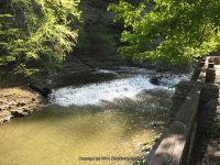
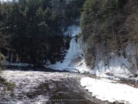
Enfield Lower Falls
Different resources has indicated different height for Lower Falls. From lower parking lot walk through the picnic and playground area to get to the falls.
Falls Below Lower Falls (Enfield Glen) Can See This Just Before Reaching Lower Falls This is a small dam. N42.39691 W76.56030
At the lowermost portion of the park (parking lot) is a small fall N42.39733 W76.55698
Falls: N42.39727 W76.56126
Landmark: Above the swimming area
Height: 32 ft to 70 ft
Elevation: 550 ft
Type: Bastion
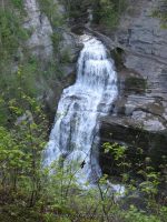
Fish Kill Falls (Enfield Glen) Fishkill Creek
From the parking lot go over behind the mill. Also as you are coming down the Upper Park Road, Enfield Creek runs along the left side of the road. There are some small waterfalls in this section. N42.40334 W76.59386
Falls: N42.40157 W76.58989
Landmark: The Old Mill
Height: 12 ft
Elevation: 936 ft
Type: Cascade
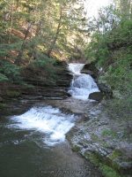
Lower Park Area starting from the beginning up to Sulphur Falls
Small Falls N42.39733 W76.55698 474 ft
Falls Below Lower Falls N42.39691 W76.56030 500 ft
Lower Falls aka Enfield Creek And Glen Falls N42.39727 W76.56126 525 ft
Falls above Lower Falls N42.39747 W76.56146 550 ft
Waterfall 1 N42.39756 W76.56283 594 ft
Waterfall 2 N42.39810 W76.56399 598 ft
Waterfall 3 N42.39843 W76.56540 603 ft
Waterfall 4 N42.39878 W76.56675 632 ft
Fall Creek Gorge and Waterfalls – 9 Named Waterfalls, Ithaca
Fall Creek Gorge and Waterfalls Tompkins County, Ithaca New York
Stream or River: Falls Creek flows into Cayuga Lake
Named waterfalls in Fall Creek Gorge: Foaming Falls, Forest Falls, Rocky Falls aka Sibley Falls and Triphammer Falls, Horseshoe Falls
Dates Visited:
5/25/2008
I have yet to see all the falls here in the park. We only made it maybe to Triphammer Falls. I wanted to include all the information I have accumulated since 2008. If the information I provided here is different or wrong, or you have additional information to provide, feel free to let me know.
Maps and Resources used to gather information:
Cornell Map
Western New York all outdoors Atlas & Field Guide Publication 2008 103 B6
200 Waterfalls In Central & Western New York “A Finders’ Guide” By Rich And Sue Freeman 2002
New York Waterfalls “A Guide For Hikers & Photographers” by Scott E. Brown 2010
World Waterfall Database
angelfire
Directions:
I-81 South in Cortland, Take exit 12 to the right onto US-11/Rt-41 towards Rt-281/Homer/Cortland and drive for .4 miles. Keep left onto Highway 281 ramp and drive for .5 miles. Take the Rt-281 S ramp towards Ithaca for 196 ft. Turn left onto Highway 281 and drive for 11.4 miles. Turn right onto W Main Street and drive for 6.0 miles. Turn left onto Dryden Road and drive for 3.3 miles. Turn right onto Tower Road for 431 ft. Turn left onto Campus Road and drive for 1.3 miles. Turn right onto Stewart Ave and drive for .5 miles.
Length of Hike: Approx 1 Mile Round Trip With The Others
Parking areas:
This loop can be accessed from four trailheads:
On University Avenue across from the Johnson Museum of Art.
Behind Risley Hall on North Campus
From the south end of the bridge that crosses Fall Creek on Stewart Avenue
At the north end of the pedestrian suspension bridge off of Fall Creek Drive
Fall Creek Falls Parking , N42.45158 W76.49093
Fall Creek Dr Parking, N42.45272 W76.48534
Fall Creek Risley Hall Parking and Trail, N42.45271 W76.48154
Fall Creek University Ave Parking and Trail, N42.45141 W76.48500
Ithaca Falls Parking, N42.45297 W76.49471
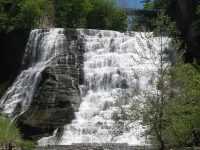
Ithaca Falls aka Olympic Falls
Falls: N42.45265 W76.49157
Landmark: Alpha Sigma Phi
Height: 150 ft
Elevation: 505 ft
Type: Cascade
Hike: 15 Minutes

Starting from Lake Street at Ithaca Falls from west to East
Waterfall Location Elevation
Ithaca Falls N42.45265 W76.49157 505 ft
Forest Falls N42.45209 W76.48831
Horseshoe Falls N42.45191 W76.48753 667 ft
Foaming Falls N42.45186 W76.48610 696 ft
Rocky Falls N42.45204 W76.48437
Fall Creek falls 1 N42.45251 W76.48351
Fall Creek Falls 2 N42.45213 W76.48253 737 ft
Triphammer Falls N42.45161 W76.48058 740 ft
Sackett Footbridge Falls Trail N42.45174 W76.47319
Class of 48 Falls N42.45328 W76.47308 835 ft
Lovers Falls aka Lover’s Leap N42.45330 W76.47099 809 ft
Fall Creek Falls 3 N42.45084 W76.46817 827 ft
Fall Creek Falls 4 look up from bridge N42.45143 W76.46665 840 ft
Mad River (Camden New York) small falls and rapids
Oneida County, Camden New York Area
For this Mad River section I have group the locations, as they are near each other.
Mad River small falls on (Old Camden Swim Hole)
Dates Visited: 3/27/2016 9/1/2014 9/29/2007
Closet Intersection: River Road and Quarry Road and Jones Road
Gps of Falls: N43.36596 W75.73517
Gps of Parking: N43.36587 W75.73672
Stream or River: Mad River flows into West Branch Fish Creek
Elevation: 614 ft
Type: Small Rapids
Hike: Roadside
Mad River small falls on (Old River Road)
Dates Visited: 4/2/2014 6/30/2013 4/13/2009 9/29/2007
Closet Intersection: River Road And Hart Road
Gps of Falls: (1) N43.38704 W75.73621
Gps of Falls: (2) N43.38644 W75.73491
Gps of Parking: N43.38656 W75.73515
Stream or River: Mad River flows into West Branch Fish Creek
Elevation: 727 ft
Type: Various
Hike: Roadside
Mad River small falls on (Jones Rd Bridge)
Dates Visited: 3/27/2016 9/1/2014 9/29/2007
Closet Intersection: Wolcott Hill Road and Jones Road
Gps of Falls: N43.36549 W75.72717
Gps of Parking: N43.36549 W75.72717
Stream or River: Mad River West Branch Fish Creek
Elevation: 650 ft
Type: Rapids
Hike: Roadside
East Branch Fish Creek Waterfalls and Rapids (Whitewater Route)
I am still trying to access all of these locations.
Driving Directions:
From I-90 W, in Westmoreland, Take exit 32 to the right towards Rt-233/Westmoreland/Rome and drive for .7 miles. Turn right onto Cider Street and drive for .1 miles. Turn right onto Highway 233 and drive for 5.7 miles. Take the Rt-49 W/Rt-69 W/Rt-365 W ramp to the left and drive for .4 miles. Take the Rt-49 W/Rt-69 W ramp to the right towards Rt-26 N/Rt-46/Downtown Rome and drive for 1.3 miles. Keep left onto Erie Blvd E and drive for 10.5 miles. Turn right onto Main Street and drive for .1 miles. Furnace Creek falls on Parking Continue on Main Street and drive north for .1 miles. Turn right onto Church Street and drive for .1 miles. Fish Creek Cabin Resort (Town Rapids and the Sand Pit) Get on Church Street and drive north for .1 miles. Turn right onto Main Street and drive for .4 miles. Turn right onto Coal Hill Road and drive for .9 miles. Turn right onto Palmer Road and drive for .6 miles. Palmer Road Parking (Palmer Road Rapids) Continue on Palmer Road and drive northeast for .3 miles. Palmer Road (Hotel California Rapids and Kellys Corner Rapids) Continue on Palmer Road and drive east for .1 miles. Turn left onto Boyd Road and drive for 1.1 miles. Fish Creek Dam Road Parking (Waterfall Wave Rapids and City of Rome Reservoir and First Wave) Continue onto Frenchtown Road and drive for .8 miles. Turn right onto Bowman Road and drive for .7 miles. Turn left onto Point Rock Road and drive for 2.4 miles. Point Rock Road Parking (Ice Pool) Continue on Point Rock Road and drive north and drive for 1 miles. Turn left onto Yorkland Road and drive for .3 miles. Yorkland Road -Put In
1 Furnace Creek (falls on)
Dates visited:
4-27-2014, 4-2-2014, 6-30-2013, 12-31-2012, 5-9-2007
There is a small memorial park near the bridge. Park there and walk to the bridge.
When you are standing on the Main Street bridge looking north, Furnace Creek flows into East branch Fish Creek on the left.
Location: Annsville Town
Closest Intersection: Main Street and Blossvale Road
Falls N43.30229 W75.61768
Parking N43.30227 W75.61828
Landmark: Small Memorial Park
Stream or River: Furnace Creek flows into Fish Creek
Elevation: 500 ft
Type: Ledges
Access: Roadside
Location: Lee Town
Closest Intersection: Point Rock Road and Sulphur Springs Road
Falls: N43.37394 W75.55711
Parking:
Landmark:
Stream or River: East Branch Fish Creek flows into Fish Creek
Elevation: 950 ft
Type: Cascade on River Walls
Access: Possible access N43.37368 W75.55118
——————————————————————–
12 Frederick W Parker Jr Bridge
Dates visited:
(4-27-2014) (4-2-2014) (6-30-2013) (12-31-2012) (5/9/2007)
This is used sometimes as a put in location
.
Location: Annsville Town
Closest Intersection:
Coal Hill Road (County Route 67a) and Sheehan Road
Falls: N43.37796 W75.56813
Parking: N43.37796 W75.56813
Landmark:
Stream or River:
Elevation: 1025 ft
Type:
Access: Roadside
Little Chuctanuanda Falls, Montgomery County, NY now Private
Please take note that LITTLE CHUCTANUANDA FALLS, is now private property. I just received information to reflect this. Remember folks that we need to keep in mind landowners wishes!!

Trenton Falls Scenic Trail, Scheduled for 2016, Oneida County, New York 3/27/2016
Trenton Falls Scenic Trail and Waterfalls
Mark your calendars folks, the 2016 open dates have been posted!
Spring Dates
Saturday May 7th 2016
Sunday May 8th 2016
Fall dates
Saturday September 17th 2016
Sunday September 18th 2016
Interesting Links
Social History: Initial Discovery
Social History: Early Settlement
Listed in the order which the waterfalls will be seen:
Morgan Dam at Trenton Falls
Aka Village Falls

Sherman Falls at Trenton Falls

Below Sherman Falls


Potash Kettle and the Narrows at Trenton Falls
Aka Cascades Of The Alhambra
Section above Sherman Falls
Lower High Falls at Trenton Falls


Upper High Falls at Trenton Falls

The current trail stops here, back in 2006 I was thankful I had the opportunity to go to its end.
Mill Dam Falls At Trenton Falls
Aka Upper Falls Or Squires Falls

Hydro Dam Falls At Trenton Falls


I am still trying to narrow down exactly what section or falls the following are referred to historical.
Bridal Veil Falls at Trenton Falls
Suydam Falls at Trenton Falls

Frenchville Gorge Waterfalls, Western Town, Oneida County, New York 3/27/2016
Frenchville Gorge is located in the Town of Western in Oneida County New York.
I found reference to this area from a photo I had seen on the
Cycle Adirondacks 2015
I have not confirmed the actual falls have individual names or not. Everyone of the locations can be seen from the roadside. Two or three of them have a short scramble to get down for closer view.
Gulf Creek (falls on) Frenchville Gorge


Big Brook (falls on) Frenchville Gorge

Big Brook Lower Section (falls on) Frenchville Gorge

Big Brook Upper Section (falls on) Frenchville Gorge

Gifford Creek (falls on) Frenchville Gorge

Wells Creek (falls on) Frenchville Gorge


Updated Waterfall Location in Fulton Town, Schoharie County, New York 3-27-2016
Krum’s Falls (Two Waterfalls)
aka Butts Falls
Historic Marker Indian Trail
Keyserkill/Schoharie Creek
Each Waterfalls is approx. 15 ft to 20 ft
Cascades
Roadside
The tops are seen from the bridge
Tributary to Panther Creek (falls on)
Parking #1 N42.55151 W74.49314
Parking #2 N42.55917 W74.48534
Burnt-rossman Hill State Forest
Burnt-rossman Hill State Forest Sign “Long Path” and Panther Creek Public Fishing Sign “Long Trail, Aqua Blazes”
Tributary to Panther Creek/Schoharie Creek
(15 ft Cascade) (25 ft Plunge) (30 ft Cascade) (12 ft Ledge) (20 ft Drop) (8 ft fall) (40 ft total of small falls and cascades) ( 4-5 more 5 ft Ledges) (5 ft Cascade) (15 ft Ledge) (5 ft Drop)
Approx. .4 Miles Roundtrip
 Schoharie NY 8-22-2014_00003.JPG")

Updated Waterfall Location in Richmondville Town, Schoharie County, New York 3-25-2016
High Street Bridge Falls (Bear Gulch Stream)
Town Of Richmondville Garage
Bear Gulch Stream/Cobleskill Creek
Falls 12 ft Dam 3 ft
Roadside
Although listed in the book as roadside, at the time we were here, the bridge was closed off with no access to either end or below the falls. There are barriers and signs all over for no trespassing. The only view is from the edge of the road just before the garage but no clear view of the complete falls.