Category Archives: Waterfalls of the Northern Region of New York State

Eatonville Falls, Lewis County Waterfall Trip on 6-7-2015 part 3

Eatonville Falls, Lewis County Waterfall Trip on 6-7-2015 part 3

Eatonville Falls, Lewis County Waterfall Trip on 6-7-2015 part 3

From the town of greig at the intersect of blue street (main street name changes to blue street) and greig road drive southeast on greig road for about 1.4 Miles. Bear left onto odett road and drive .3 Miles to pine grove road. Turn left again then a right onto eatonville road. Drive 1.4 Miles on eatonville road which changes to otter creek truck trail. Drive over the bridge to the parking area.

Small campground and picnic area, no restrooms! There are trails on both sides going upstream. I only took the trail on the right going downstream. The trails are very easy.

American Whitewater Rafting Route Otter Creek: Partridgeville road to Pine Grove Road

Tracks for Eatonville Falls on the Otter Creek Trail location on Wikiloc

EATONVILLE FALLS MAY BE NAMED THE FIRST RAPID ON THE WHITEWATER ROUTE FOR THIS SECTION.

EATONVILLE FALLS on OTTER CREEK

FIRST RAPID IV on OTTER CREEK

BRIDGE RAPID IV on OTTER CREEK

THIS LAST SECTION IS LOCATED A SHORT DISTANCE DOWN BELOW THE BRIDGE

Lewis County Waterfall Trip on 6-7-2015 part 2

Lewis County Waterfall Trip on 6-7-2015 part 2

This is a roadside waterfall, most likely best seen in the spring or fall.
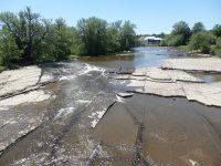
MARTINSBURG FALLS

This next set of photos were taken at different areas along Gomer Hill Road. We had meant to be on the next road over. Good thing! All of it are roadside views only.

MILL CREEK falls on (GOMER HILL ROAD)

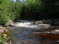
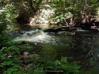
This next one is not really considered a fall, and currently I find no name for it. Roadside only from the bridge.

MILL CREEK (SILVER CREEK) falls on (CEMETERY ROAD)

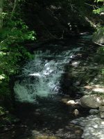
BOTH MOORES FALLS AND SILVER CREEK FALLS ARE LOCATED ON PRIVATE PROPERTY. THE HOME OWNER GRANTED ME PERMISSION TO ACCESS THIS WATERFALL AND ANOTHER ONE ON THEIR PROPERTY. THE HOME OWNER ALSO REQUESTED THAT I POST ABSOLUTELY NO INFORMATION ON THE LOCATION, BUT DID GRANT ME PERMISSION TO POST THE PHOTO. I WAS ALSO ASKED IF ANY RESOURCES OUT THERE HAD POSTED INFORMATION TO THIS LOCATION TO PLEASE REMOVE IT. THE HOMEOWNER STATED THEY HAVE BEEN HAVING TROUBLE WITH FOLKS TRESPASSING, HAVING CAMP FIRES, AND EVEN TRYING TO CAMP, AS WELL AS LEAVING GARBAGE. THIS HAS LEAD TO THERE DECISION TO PRIVACY. PLEASE RESPECT HOME OWNERS. THE HOME OWNER ALSO STATED THAT, LIKE ME, IF WE STOP AND KNOCK AND ASK…..YOU MAYBE GRANTED!!

MY MAPS SHOW THE STREAM AS MILL CREEK, RESOURCES HAVE IT LISTED AS SILVER CREEK.

MOORES FALLS

SILVER CREEK FALLS (MILL CREEK)

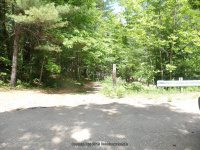
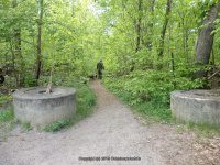
This next one, the story for this! We wasted so much time. If you ever traveled in this area you would understand. We drove over 8 miles on this dirt road and totally by passed the locations we were looking for. Fact was we could not find actual trail starts and kept going. Needless to say driving all the way to the end and had to turn around and back track the 8 miles. It would be nice if there was any sign stating DEAD END road!! Anyways, right at the end was a turn around and this was there.

OTTER CREEK falls on (PARTRIDGEVILLE ROAD)

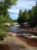
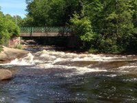
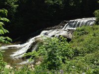
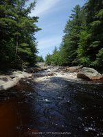
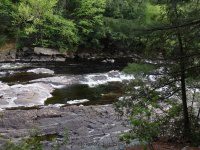
Talcottville Falls was a revisit for me. The last time I was here it was in the winter. What a difference. That and this time could see the trail down in.

Tracks for Talcottville Falls on Wikiloc

TALCOTTVILLE FALLS aka SUGAR RIVER FALLS

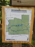
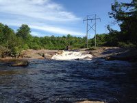
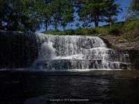
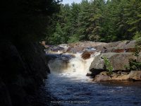
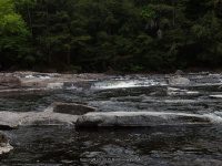
This is also a re visit. I had did a post on this earlier I believe. A well known attraction. This time I went in from the northern end and took the south trail in.

Tracks for Whetstone Creek Falls on Wikiloc

WHETSTONE CREEK FALLS

Lewis County Waterfall Trip on 6-7-2015 part 1

Lewis County Waterfall Trip on 6-7-2015 part 1

Lewis County Waterfall Trip on 6-7-2015 part 1

From the intersection of highway 12 and glenfield road, drive .2 Miles east on glenfield road. You will come to an intersection of main street. Turn left onto main street and drive .2 Miles to a right onto grieg road. Drive .5 Miles on grieg road to a left onto otter creek road. Drive 1.5 Miles on otter creek road to the intersection of pine grove road. Turn left here onto pine grove road and drive 1.4 Miles. Where rudd road is on your right. Turn onto rudd road and drive .3 Miles to the end where the bridge is out. This is the take out spot for the whitewater rafters.

The trail is fairly easy and is .5 mile round trip on the west side trail. The falls below the bridge is only a few hundred yards and also can be viewed from the bridge.

Additional Resources

EASTERN NY ALL OUTDOORS ATLAS AND FIELD GUIDE

From the American Whitewater Rafting Route: Bradish Road to Old Pine Grove Road

Wikiloc tracks for The Independence River Falls

Parking and Trail head.

INDEPENDENCE RIVER FALLS

Photos taken here also include the Bridge Boof IV Rapids, and Fat Lady IV Rapids

I believe by the photos, that the Bridge Boof IV Rapids may also be the same as Hidden Falls

RUDD ROAD FALLS on INDEPENDENCE RIVER aka HIDDEN FALLS

Northern New York Waterfalls


BRIDGE BOOF IV-RAPIDS on INDEPENDENCE RIVER

FAT LADY IV-RAPIDS on INDEPENDENCE RIVER

Fat Lady is located in the section below the Independence River Falls. The photos are included under the Independence River Falls.

The Wall IV Rapids and the Independence river (falls on) are located downstream from the bridge. I firmly believe I had viewed the latter from the other road, as can see by the tracking.

THE WALL IV-RAPIDS on INDEPENDENCE RIVER

INDEPENDENCE RIVER falls on

This section are the photos I had taken when we took the trail on the west side of the river, going as far as we could just below the dam. Another trip is planned to this location taken the trail on the east side to go further upstream for the other falls listed here.

Lewis County Waterfall Road Trip on 5-23-2015

Lewis County Waterfall Road Trip on 5-23-2015

Lewis County Waterfall Road Trip on 5-23-2015

INMAN GULF RAINBOW FALLS

Tracking on Wikiloc for Inman Gulf

THE TRAIL IS APPROXIMATELY 1 MILE TO THE RAINBOW FALLS OVERLOOK N43.83144 W75.83506. THE TRAIL ITSELF IS RELATIVELY EASY AND THERE ARE SIGNS ALONG THE WAY.

KINGS FALLS aka DEER RIVER FALLS

Tracking on Wikiloc for Kings Falls Trail

This is an easy walk on a graveled road. It is approximately 1.8 mile round trip.

HIGH FALLS (COPENHAGEN)

Every time I am in this area I try and see about access. Will continue to do so until I get photos.

COPENHAGEN FALLS

This is a small roadside waterfall.

BLANCHARD CREEK FALLS aka KNICKERDOCKER FALLS

A return to this location is planned. We had a hard time finding where the trail was, or to get permission.

Stone Valley Cooperative Recreation Area Road Trip 5-23-2015

Stone Valley Cooperative Recreation Area Road Trip 5-23-2015

Stone Valley Cooperative Recreation Area Road Trip 5-23-2015

This took me some time to put together. These locations are now published. Click on the links for more information.

The following links are great resources

The Stone Valley Trail, Colton, NY

American Whitewater Stone Valley: Colton to Brown’s Bridge

Tracking on Wikiloc for Stone Valley Trail

STONE VALLEY TRAIL with WATERFALLS

This is the parking area to the start of the trail. Also the put-in for the whitewater rafters.

From the parking area, there is a small trail on the left side that leads down to the dam and the top of Colton Falls.

COLTON DAM (STONEY VALLEY TRAIL)

On the trail you will come to a sign in register. This area is referred to as the “Whitewater Excitement”

COLTON FALLS 5.0 (STONEY VALLEY TRAIL)

Tannery Ledges is .2 miles down from the dam.

TANNERY LEDGES IV (STONEY VALLEY TRAIL)

At 0.4 miles you come to the Mushroom Ledges. This area is referred to as the “Bedrock”

MUSHROOM LEDGES III (STONEY VALLEY TRAIL)

At 0.5 miles you come to the Narrows

THE NARROWS (STONEY VALLEY TRAIL)

At 0.8 miles you come to the Tubs

THE TUBS (STONEY VALLEY TRAIL)

At 0.9 miles you come to the Island Falls

ISLAND FALLS 5.0 (STONEY VALLEY TRAIL)

At 1.0 mile you come to the 200 Proof Rapids

200 PROOF IV (STONEY VALLEY TRAIL)

Lucy’s Hole is also referred to as “The Gut” This is located in the area called the “High Terrace”

LUCYS HOLE (STONEY VALLEY TRAIL)

O’malley Brook overlook is in the area called “Cathedral Grove”

OMALLEY BROOK FALLS (STONEY VALLEY TRAIL) 

I have to verify but I was for sure this was on the Independence River but Wikiloc is showing Otter Creek

I have to verify but I was for sure this was on the Independence River but Wikiloc is showing Otter Creek

I have to verify but I was for sure this was on the Independence River but Wikiloc is showing Otter Creek


Eatonville

Eatonville

Eatonville
  

Whetstone

Whetstone

Whetstone
WHETSTONE WIKILOC TRAIL

Home » Whetstone » WHETSTONE GULF TRAIL START
Home » Whetstone » WHETSTONE GULF, FIRST SECTION
Home » Whetstone » WHETSTONE GULF, 2ND SECTION
Home » Whetstone » WHETSTONE GULF FALLS

Talcottville

Talcottville

Talcottville
TALCOTTVILLE WIKILOC TRAIL

Home » Talcottville » TALCOTTVILLE FALLS 6-7-2015

Road trip to Hamilton County New York area now published 5-10-2015

Road trip to Hamilton County New York area now published 5-10-2015

Road trip to Hamilton County New York area now published 5-10-2015
THESE ARE FROM OUR ROAD TRIP ON 5-10-2015

ALGONQUIN HYDRO DAM   Hamilton County, New York

AUGER FALLS  Hamilton County, New York

AUSTIN FALLS  Hamilton County, New York

BEECHER CREEK FALLS  Saratoga County, New York

BEECHER CREEK FALLS 2  Saratoga County, New York

CHRISTINE FALLS  Hamilton County, New York

GRIFFEN FALLS  Hamilton County, New York

JIMMY CREEK EAST LOWER FALLS  Hamilton County, New York

JIMMY CREEK WEST FALLS  Hamilton County, New York

RIVER ROAD (FALLS ON) NORTHVILLE  Hamilton County, New York

SACANDAGA RIVER FALLS ON  Hamilton County, New York

WHISKY BROOK FALLS  Hamilton County, New York