Whitaker Middle Falls

Roadtrip on 10-18-2014

Roadtrip on 10-18-2014

Roadtrip on 10-18-2014 through Lewis and Oneida Counties

DENLEY DAM AND FALLS LEWIS COUNTY

This is a portage site for kayakers and canoes. There is a small parking area and the dam and falls can be seen from there.

ROCK ISLAND DAM AND FALLS LEWIS COUNTY

This is also another portage area for kayakers and canoes. The gate was open as they had the whitewater rafting run going on this weekend. Also from here you can look upstream and see Port Leyden dam and falls in the distance.

PORT LEYDEN DAM AND FALLS LEWIS COUNTY

We did not try accessing this from the other side as before. There is a school located there, and we parked in the lot and did a short scramble to get better views.

MILKHOUSE FALLS LEWIS COUNTY

The actual location for this waterfall is posted on private property. I realized when I got home and threw in my tracks in my mapping program, that I was at the backside of this. As I mentioned in my description, the land was not posted. HOWEVER, I do not recommend visiting location by this means. It is unsafe and very much a big liability should someone get hurt. I was following a stream down and came upon it, I was at the top of the falls, and went out and around to see what it looked like. But the whole area looks as though someone used it as a dump site and there is glass and metal everywhere. I would say to try and contact someone and get permission by other location listed on internet resources. And the same time maybe get a look at the Orthodox Church sitting there.

SWAN’S FALLS LEWIS COUNTY

This is on privately owned property but good views can be seen from the road.

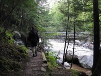
ROARING BROOK UPPER FALLS LEWIS COUNTY

This waterfall is located within walking distance from the gate of Whitaker Falls State Park.

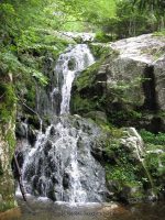
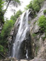
WHITAKER FALLS STATE PARK LEWIS COUNTY

I could not believe how much work had taken place at the park. However the trail in and around the waterfalls is still in dire need of repair and safety fencing. We happen to be lucky and came across a rope that someone had tied up and that’s how we got down in there. When we got down there was a group of young adults that we encountered and found out they had just been the ones to put the rope there. We were very thankful they left the rope there for us to get back

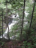
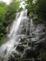
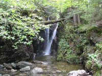
UNNAMED FALLS ON HWY 12 NEAR RAILROAD TRACKS LEWIS COUNTY

This was a delight to see. How we missed it on the way up, no clue. There is no trail up to the top. It was posted on the left hand side of the falls. We tried walking up the falls rock hopping as far as we could. It was very slippery, as it was raining. From the road you will have to walk across the railroad tracks, but this can be seen right from the highway.

BAKERS FALLS ONEIDA COUNTY

LANSING KILL FALLS ONEIDA COUNTY

The access to both Lansing and Bakers is same parking, same path. There is parking for maybe two or three cars. You can see the falls right from the road. The canal trail system is right there also. The path was very slippery and steep.

Opalescent Falls, Essex County, New York

Hiking Trip To Hanging Spear Falls 10-15-2008

Hiking Trip To Hanging Spear Falls 10-15-2008

Hiking Trip To Hanging Spear Falls 10-15-2008

This was my first big hike and my most memorable one!! This is when I learned about how heavy a backpack gets when you are completely soaked!! I learned my pack was not very comfortable, and later down the road purchased one that sat better on my hips!! I learned very quickly what a Thunder Box was….lol So below I have posted albums for every section of the hike from beginning to end.

To start out our first day we did not get an early start and arrived at the trailhead register about 12 noonish. I was so ready for the hike in!!!

1 to state boundry sign_00003.JPG
1 to state boundry sign_00019.JPG

TO SEE MORE PHOTOS CLICK LINK BELOW

Home » Hiking Trip To Hanging Spear Falls 10-15-2008 » Hanging Spear Falls Trail Hike #1-sign in at trail head to state boundry sign

HENDERSON MONUMENT AREA

2 henderson monument_00012.JPG
Home » Hiking Trip To Hanging Spear Falls 10-15-2008 » Hanging Spear Falls Trail Hike #2-from state boundry sign to henderson monument

We arrived at the first available lean to about 5:30ish. I took some pics of around the lean to

3- henderson monument to lean to_00005.JPG
3- henderson monument to lean to_00006.JPG

We got up and moving and headed down to Opalescent Falls and Hanging Spear Falls. The view first thing in the morning from the comforts of my sleeping bag was awesome!!

4-lean to to the dam_00020.JPG

OPALESCENT UPPER FALLS  We did not see a trail to this, without having to bushwack to get to.

OPALESCENT UPPER ESSEX NORTHERN NY 10-15-2008_00001.JPG

OPALESCENT FALLS

OPALESCENT FALLS ESSEX NORTHERN NY 10-15-2008_00011.JPG

HANGING SPEAR FALLS

HANGING SPEAR 10-15-2008_00016.JPG

before heading back to camp we went over and checked out the Livingston Lean to area

5-from dam to livingston lean to_00001.JPG
5-from dam to livingston lean to_00009.JPG
6 livingston lean back to dam_00002.JPG

Here is where I just had to take a few pics of our lovely outdoor facilitiy!! Now mind you, the main trail goes right by this, and can be seen from the trail. No more words necessary!!! Oh and in the Rain!!!!

7-dam back to lean to_00005.JPG
7-dam back to lean to_00007.JPG
7-dam back to lean to_00009.JPG

It had started rain as we headed back out. It actually did rain all the way back out!!

8 lean to to the state boundry_00001.JPG
8 lean to to the state boundry_00020.JPG
9-second bridge to first bridge_00011.JPG
9-second bridge to first bridge_00015.JPG

We did take the time to take some pics of the waterfall at the first bridge.

10 first bridge to trailhead_00007.JPG
10 first bridge to trailhead_00015.JPG
Home » Hiking Trip To Hanging Spear Falls 10-15-2008 » Hanging Spear Falls Trail Hike #10-from the first bridge and waterfalls to beginning trailhead
Prospect Quarry Falls, Oneida-Herkimer County, New York

New Additions 10-25-2014

New Additions 10-25-2014

New Additions 10-25-2014
BRIDAL VEIL FALLS IN DELAWARE COUNTY

COOKS FALLS IN DELAWARE COUNTY

CLIFFORD FALLS IN ESSEX COUNTY

HANGING SPEAR FALLS IN ESSEX COUNTY

SCHROON FALLS IN ESSEX COUNTY

SQUAW BROOK FALLS IN HAMILTON COUNTY

MILL CREEK FALLS ON IN HERKIMER COUNTY

WEST CANADA CREEK FALLS ON IN HERKIMER COUNTY

NATURAL BRIDGE FALLS IN JEFFERSON COUNTY

COPENHAGEN FALLS IN LEWIS COUNTY

GLEASMANS FALLS IN LEWIS COUNTY

Fillmore Glen State Park

Changes and Additions 10-22-2014

Changes and Additions 10-22-2014

Changes and Additions 10-22-2014
I HAVE STARTED MAKING SOME CHANGES TO THE WEBSITE TO MAKE IT EASIER FOR BOTH THE READER AND MYSELF.

THE FIRST CHANGE IS NOW THERE IS A DROP DOWN ON THE NEW YORK STATES WATERFALL TAB THAT WILL ALLOW YOU TO GO DIRECTLY TO THE REGION YOU WISH TO NARROW DOWN ON. THIS I AM IN HOPES WILL MAKE IT A LITTLE EASIER FOR SCROLLING PURPOSES.

I HAVE PUBLISHED FILMORE GLEN STATE PARK WHICH IS LOCATED IN CAYUGA COUNTY, ALONG WITH AS MUCH DETAILED INFORMATION FROM MY POINT OF VIEW OF THE HIKE. THERE ARE PHOTOS BACK IN 2004 AND MY LATEST VISIT IN JUNE 2014.

FILMORE dam and hogsback falls_00012.JPG

I HAVE ALSO PUBLISHED A DETAILED DESCRIPTION OF VAN HORNSVILLE FALLS AND TRAIL WHICH IS LOCATED IN HERKIMER COUNTY, AT THE OWEN D YOUNG SCHOOL. MY FIRST VISIT WAS BACK IN MARCH OF 2010, AND I REVISITED IN OCTOBER OF 2014.

9-DAVES LOOKOUT 10-2-2014_00030.JPG
Van Hornsville, Cheesebox Falls

Van Hornsville Falls, Robert B Woodruff Outdoor Learning Center – 7 Waterfalls

Van Hornsville Falls, Robert B Woodruff Outdoor Learning Center – 7 Waterfalls

Van Hornsville Falls, Robert B Woodruff Outdoor Learning Center – 7 Waterfalls
at Owen D Young School

Location:
Stark Twn
First Visit:
3/6/2010
Region:
Central
County:
Herkimer
Park/Area:
Robert B Woodruff Outdoor Learning Center
Gps of Falls:
N42.89701 W74.82514
Gps of Parking:
N42.89659 W74.82559
Landmark:
Owen D Young School
Stream/River/Watershed:
Otsquago Creek
Elevation:
1114 ft
Level of Difficulty/Hiking Distance:
Main Loop .64 Mile and Additional Side Trails .32 Miles
My Resource:
Mohawk Region Waterfall Guide “From the Capital District to Cooperstown & Syracuse” By Russell Dunn 2007
Book Resource:
Mohawk Region Waterfall Guide “From the Capital District to Cooperstown & Syracuse” By Russell Dunn 2007
Nearest Intersection:
Rte 80 and Wiltse Hill Rd
Directions:
From I-90 E, in Canajoharie, Take exit 29 to the right towards Rt-10/Canajoharie/Sharon Springs and drive for .5 miles.Turn right onto E Main St and drive for 3.6 miles. Turn left onto Main St and drive for .2 miles. Turn right onto Main St and drive for 11.5 miles. Turn left onto Tilyou Rd for 187 ft.
Comments/Notes:
See below

For more information and photos on the individual locations please click on the following links

Van Hornsville Waterfalls – Barbara Smit Young Arboretum Waterfall
Van Hornsville Waterfalls – Cheese Box Factory and Falls
Van Hornsville Waterfalls – Creamery Falls
Van Hornsville Waterfalls – Dave’s Look Out Falls at
Van Hornsville Waterfalls – Kelly Falls
Van Hornsville Waterfalls – Main Falls and Tufa Caves
Van Hornsville Waterfalls – Saw Mill Site and Falls

Van Hornsville Waterfalls - Dave's Look Out Falls at, Herkimer County, New York

Van Hornsville Waterfalls – Dave’s Look Out Falls at, Herkimer County, New York

Fillmore Glen State Park

Fillmore Glen State Park – 8 Named Waterfalls

Fillmore Glen State Park – 8 Named Waterfalls

Fillmore Glen State Park – 8 Named Waterfalls

Location:
Locke Twn
First Visit:
6/19/2004
Region:
Central
County:
Cayuga
Park/Area:
Fillmore Glen State Park
Gps of Parking:
N42.69714 W76.41545
Gps of Trailhead:
N42.69714 W76.41545
Stream/River/Watershed:
Dry Creek
Height of Falls/Type:
Various
Level of Difficulty/Hiking Distance:
4 Mile Loop, 2 Hours
Maps:
Western New York all outdoors Atlas & Field Guide Publication 2008
Trails Websites:
My Resource:
Western New York all outdoors Atlas & Field Guide Publication 2008
Book Resource:
New York Waterfalls “A Guide For Hikers & Photographers” by Scott E. Brown 2010
Brochures/Travel Guides/Visitor Guides:
Filmore Glen State Park
Additional Information:
Nearest Intersection:
Hwy 38 and Hwy 38a and N Main St
Directions:
From I-81 South in Cortland, take exit 12 to the right onto US-11/Rt-41 towards Rt-281/Homer/Cortland and drive .4 miles.  Keep left onto S West St ramp and drive .5 miles. Take the Rt-281 N ramp to the right towards Tr-90/Homer and drive .4 miles. Turn left onto Cayuga St and drive 10.4 miles. Turn right onto Toll Gate Rd and drive 3.8 miles. Turn right onto Hwy 38 and drive .3 miles. There will be signs along the way to help direct you to the park.
Comments/Notes:
Named waterfalls in the park: Cowshed Falls, Dalibarda Falls aka Lower Falls and Dry Falls, Hogsback Falls (Historical Name), Pinnacle Falls (Historical Name), Pinnacle Lower Falls, and Pinnacle Upper Falls

For additional information please click on the following links:
Fillmore Glen – Cowshed Falls
Fillmore Glen – Cowsheds Upper Falls
Fillmore Glen – Pinnacle Falls (Historical Name)
Fillmore Glen – Dalibarda Falls
Fillmore Glen – Pinnacle Lower Falls
Fillmore Glen – Pinnacle Upper Falls
Fillmore Glen – Hogsback Falls (Historical Name)
Fillmore Glen – Upper Falls

A COUPLE OF BUSINESSES TO SHARE

A COUPLE OF BUSINESSES TO SHARE

A COUPLE OF BUSINESSES TO SHARE
ON OUR LAST ROAD-TRIP WE HAD THE PLEASURE OF FINDING ACCOMMODATIONS AT ROWE’S COTTAGES. VERY FRIENDLY AND CLEAN ROOMS. KEEP THEM IN MIND IF YOUR TRAVELING UP NEAR SCHROON LAKE. SAME OWNER TO THE STARRY NIGHT CABINS.

WE ALSO STOPPED INTO GOKEY’S TRADING POST. CHATTED WITH THE OWNER A BIT TRYING TO FIGURE OUT HOW HE WAS OR MAY HAVE BEEN RELATED TO A FRIEND OF MINE. THERE WAS EVERYTHING YOU CAN THIS OF IN MR GOKEY’S STORE. STOP IN AND CHECK IT OUT.

Whiteface Mountain Highway, waterfall, Essex County, New York State

Road-trip September 27-28 2014 Whiteface Mountain

Road-trip September 27-28 2014 Whiteface Mountain

Road-trip September 27-28 2014 Whiteface Mountain
Well….it was one of those spontaneous decisions to head up north, to see the fall foliage! Destination-Whiteface Mountain….
Got a late start yesterday, getting on the road somewhere around 1:00-1:30pm with a 4 hour drive ahead of us. No plans, no pre-determined stops..just a throw and go….the throw and go, no planning I so much dislike…it was our first stop up at Inlet, that I realized I had grabbed the old camera, which works when it seems to want too….so I suffered with trying to utilize the cell phone. Now mind you….I have not really practiced taking pics for any real purpose with the Iphone.

We managed to hit a couple of new waterfall locations for me. We also re-visited some old ones. Drove by several ones I wanted to hit, but had to remind myself our destination was Whiteface. The new ones were Squaw Brook Falls and Clifford Falls. The re-visited ones were Schroon Falls and Split Rock Falls and the falls on route 73, which I still yet need to verify exact information on. I also took a few more pics of the waterfall you see going up the Whiteface Memorial Highway.

Now, I would like to take a moment and go back to Schroon Falls. We again asked some folks in Schroon Lake if they knew of the whereabouts of Schroon Falls. I have information that there is 2 different locations with different height and distance. I still cannot located the second one.

I am currently behind on getting photos posted here to website. Will try my best to at least get the new ones up.

I just wanted to also share that this trip, was my grandson (6 years old) first actual big climb. This was the trail at the top of Whiteface Mountain. My grandson did awesome with the length of travel time as well. I am so proud of him. Also cannot forget to mention my little Lilabelle (Chihuahua) also made the great climb! I had my hands full, dog in one, grandchild in the other not to mention, water bottle and cell phone and old camera!


Beaver Meadow Falls, Adirondack Mountain, Essex County, New York

St Huberts, Essex County, Northern, New York 8-11-2011 Hike

St Huberts, Essex County, Northern, New York 8-11-2011 Hike

St Huberts, Essex County, Northern, New York 8-11-2011 Hike
I am going to do by best here with piecing together the hike in the St Huberts area. This is written up for a few friends that was inquiring on the New York Waterfalls group

We arrived at the trailhead visitor parking area at about 8am. You first have to park in designated area, and then walk down the Ausable Club road to the trail beginning.

We started off by taking the West River Trail. We were going to go to Russell Brook Falls first, but was told at the gate that it was on private property.

We arrived at Pyramid Falls at about 9:50am

The next set of photos were taken before we got to Wedgebrook Falls

We arrived at Wedgebrook Falls at about 11:01am

The next set of photos were taken before reaching Beaver Meadow Falls

We arrived at Beaver Meadow Falls at about 11:30am

Our next stop we came to Rainbow Falls. We arrived here at about 12:36pm

From here we were headed for Fairy Ladder Falls, or so we thought! We crossed over to the East side and headed towards what we thought the trail to Fairy Ladder. Instead we ended up at Fish Hawk Cliffs. We arrived here at about 2:16pm

It was at this point we had to make a decision. We seen no signs pointing the way to Fairy Ladder. What we did not know at the time, was that instead of taking the trail to Fish Hawk Cliff, we should have continued straight on the trail that connects to the Gill Brook Trail and should have gone right. But we did not know this.

We climb back down and got onto the Gill Brook Trail and decided we had to head back out before dark. We got to the Gill Brook trail at about 2:47pm, we were headed for Lake Road. I am glad we did not trackback to get to Lake road or we would have not seen the falls along the Gill Brook including Artists Falls

I believe Artist Falls was one of the first few photos shown here..

We got to the gate at about 4:58 pm and headed back to the car.

I hope this will help others that are planning on this hike and are new to the area as we were. Word of advice…do not try this hike when you are sick!!! Holy Cow…we did not sleep well the night before, coughing and feverish and tired before even starting….I was determined to take the hike anyways…brutal!!!

Powered by Wikiloc
Carpenters Middle Falls, Cayuga County, New York State

Bahar Preserve – Carpenter Falls – 3 Named Waterfalls

Bahar Preserve – Carpenter Falls – 3 Named Waterfalls

Bahar Preserve – Carpenter Falls – 3 Named Waterfalls

AKA:
Grey Cliff Falls
Location:
Niles Twn
First Visit:
8/10/2008
Region:
Central
County:
Cayuga
Park/Area:
Bahar Preserve
Gps of Falls:
N42.81213 W76.34352
Gps of Parking:
N42.81329 W76.34155
Gps of Trailhead:
N42.81329 W76.34155
Landmark:
Sign For Carpenters Falls
Stream/River/Watershed:
Bear Swamp Creek
Height of Falls/Type:
67 ft, Freefall
Elevation:
1200 ft
Level of Difficulty/Hiking Distance:
.4 Miles Roundtrip
Maps:
Western New York all outdoors Atlas & Field Guide Publication 2008, Delorme Atlas & Gazetteer New York State 9th Edition 2011
Trails Websites:
My Resource:
Western New York all outdoors Atlas & Field Guide Publication 2008, Delorme Atlas & Gazetteer New York State 9th Edition 2011
Book Resource:
200 Waterfalls In Central & Western New York “A Finders’ Guide” By Rich And Sue Freeman 2002
Additional Information:
Nearest Intersection:
Appletree Point Rd and Carver Rd
Directions:
From I-81 South in Cortland, take exit 12 to the right onto US-11/Rt-41 towards Rt-281/Homer/Cortland, and drive .4 miles.  Keep left onto S West St ramp and drive .5 miles.  Take the Rt-281 N ramp to the right towards Tr-90/Homer and drive 1.2 miles. Turn left onto Hwy 41 and drive 2.5 miles. Turn left onto Hwy 41a and drive  14.3 miles. Turn right onto Appletree Point Rd and drive .5 miles. You will see a Carpenters Falls sign on your left.
Comments/Notes:
From parking area take the left trail for .2 miles

For more information click on the following links:
Bahar Preserve – Carpenter Falls aka Grey Cliff Falls
Bahar Preserve – Carpenter Middle Falls
Bahar Preserve – Carpenter Lower Falls aka Angel Falls