Category Archives: Essex County

Waterfalls of New York State 100+ Challenge, Dig the Falls, part 5, The North Country Region

Waterfalls of New York State 100+ Challenge, Dig the Falls, part 5, The North Country Region

For more information on this challenge click here
To purchase “Waterfalls of New York State”, click here 
To purchase “A Waterfall Guide to Letchworth State Park” by Scott A. Ensminger and Douglas K. Bassett, click here

The following list is the first set of locations listed in the book “Waterfalls of New York State” by Scott A. Ensminger of (Western New York Waterfall Survey), David J. Schryver of (Northern New York Waterfalls) and Edwards M. Smathers of (Dig the Falls)

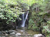
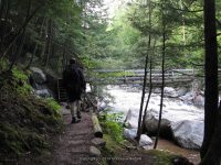
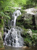
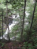
Be sure to check them out! I myself have personally contributed a lot of waterfall location information to both Mr. Edward Smathers and Mr. David Schryver. I am currently a team member with “Dig the Falls”. The simple rules of this challenge, is to visit 100 waterfall locations in the book. One location may have several waterfalls, but counts as one location. Click on the links (I have visited) in the boxes below, which will take you to additional information pages. (NOTE: format is different then the first 4 parts of challenge already posted prior. I thought I had posted all of these, but, ummm well, I did not)

Park, Area
County
Waterfall Name
Aka
 
Oswego
——-
——-
Oneida
——-
——-
Lewis
Sugar River
——-
Lewis
High Falls
——-
Lewis
Whetstone Creek Falls, Whetstone Gulf Falls
Whitaker Falls State Park
Lewis
——-
——-
Lewis
——-
——-
Lewis
Frenchs Mills and Myers Mills
——-
Lewis
——-
——-
Jefferson
Burr’s Mill Falls, Cider Mill Falls
——-
Jefferson
Boynton Creek, falls on
——-
——-
Jefferson
——-
——-
Jefferson
Great Falls, Watertown Falls
——-
Jefferson
——-
——-
Jefferson
Glen Park Falls
——-
——-
Jefferson
Evans Mills Falls, The Falls at Evans Mills
——-
St. Lawrence
Fullerville Falls
——-
——-
St. Lawrence
Brown’s Falls
——-
——-
St. Lawrence
Butter Tub Falls
——-
——-
St. Lawrence
Chipmunk Falls
Schuyler Falls
——-
St. Lawrence
——-
——-
St. Lawrence
——-
——-
St. Lawrence
——-
——-
St. Lawrence
Flat Rock Falls
——-
——-
St. Lawrence
——-
——-
St. Lawrence
Stewart Rapids
——-
St. Lawrence
Bulkhead Falls
——-
——-
St. Lawrence
Large Marge
——-
St. Lawrence
——-
——-
St. Lawrence
——-
——-
St. Lawrence
——-
Willow Island/Falls Island
St. Lawrence
leftside
Willow Island/Falls Island
St. Lawrence
——-
——-
St. Lawrence
——-
——-
Franklin
——-
——-
Franklin
——-
——-
Franklin
——-
Ausable Chasm
Clinton Essex
Tiny Cascades and Rapids, downstream from Horseshoe Falls
Ausable Chasm
Clinton Essex
——-
Ausable Chasm
Clinton Essex
Adgate Falls, Birmingham Falls, Anderson Falls
——-
Essex Clinton
Alice Falls
Little Falls
——-
Essex
Jay Falls
——-
High Falls Gorge
Essex
——-
High Falls Gorge
Essex
——-
High Falls Gorge
Essex
——-
High Falls Gorge
Essex
——-
High Falls Gorge
Essex
——-
——-
St. Lawrence
Bog River Falls
Upper,Lower
AMR
Essex
——-
——-
Essex
——-
——-
Essex
——-
——-
Hamilton
——-
——-
Hamilton
Auger Falls
——-
Hamilton
Auger Falls
——-
Hamilton
Auger Falls

Waterfalls, Whats areas and types interest You! 6-5-2017

Waterfalls, Whats areas and types interest You!

I am curious! We all view our destinations based on our personal preferences. For all you “Waterfall” folks, what areas or types of waterfall locations do you choose to see.

Do you like long hikes to get to a waterfall?
Do you prefer a roadside stop here and there along a route to your end destination?

Old City Road, falls on Herkimer County, New York

Old City Road, falls on Herkimer County, New York

Do you prefer hikes less then 1 mile to see a waterfall?

Buttermilk Falls, Little Falls, Herkimer County, New York

Buttermilk Falls, Little Falls, Herkimer County, New York

Would you only visit tourist areas of attractions like Niagara Falls, Watkins Glen State Park or Letchworth State Park?

Letchworth State Park, Middle Falls

Letchworth State Park, Middle Falls

Would you camp in the woods over night, just to see waterfalls?

Hanging Spear Falls 10-15-2008_00017

Hanging Spear Falls 10-15-2008

If you were to choose a waterfall destination where would it be?

I would like to see your comments!

My point of view
I love waterfalls, of course. I do not like lots of people, therefore I would choose lesser known places to travel to. As well as the adventure it brings. Niagara Falls is a totally awesome place, yet I found every time I went it was too overwhelming with all the people. I love following the “Whitewater rafting/kayaking” folks. I love watching as they plummet over the falls! Sure there on plenty of on lookers, cheering on their friend or family or spouses. Everyone is there with the same common interest. That and I get to learn and find more waterfalls in which is classified as rapids! I have had more adventures and stories to tell for years later! Cool, I think so.

Agers Falls, Lewis County, New York, Moose River

Agers Falls, Lewis County, New York, Moose River

What is one of your favorite waterfall adventures? Share yours here!


Gill Brook Trail Waterfalls, St. Huberts, Keene Valley, New York

Artist Falls and Gill Brook Trail Waterfalls

Artist Falls and Gill Brook Trail Waterfalls

Artist Falls and Gill Brook Trail Waterfalls (St Huberts)

AKA:
—–
Location:
Keene Twn
First Visit:
8/11/2011
Region:
Northern
County:
Essex
Park/Area:
—–
Gps of Falls:
N44.12673 W73.80830
Gps of Parking:
N44.14903 W73.77027
Gps of Trailhead:
—–
Trail Name/Reference to:
—–
Landmark:
—–
Stream/River/Watershed:
Gill Brook
Height of Falls/Type:
10 ft, to 20 ft, Cascade
Elevation:
1811 ft
Level of Difficulty/Hiking Distance:
0.5
Wikiloc:
—–
Whitewater Rte/Canoe Rte Map:
—–
Maps:
Eastern New York all outdoors Atlas & Field Guide Publication 2008
Trails Websites:
—–
My Resource:
Eastern New York all outdoors Atlas & Field Guide Publication 2008
Book Resource:
Brochures/Travel Guides/Visitor Guides:
—–
Additional Information:
Photos And Information I Contributed To or Posted To Other Websites:
—–
Nearest Intersection:
St Huberts Rd and Ausable Club Rd and Lake Rd
Directions:
From I-87 N in North Hudson, Take exit 30 to the right onto US-9 towards Rt-73/Keene Valley/Keene and drive for .2 miles. Turn left onto US 9 and drive for 2.2 miles. Keep left onto Hwy 73 N and drive for 5.4 miles. Turn left onto Ausable Rd and drive for .2 miles to the parking area.
Comments/Notes:

Waterfalls on the Gill Brook
#1 15 ft Block     N44.12480 W73.80906

#2 Chute             N44.12397 W73.80948
#4 15 ft Flume   N44.12293 W73.80988
#5 9 ft Cascade  N44.12247 W73.81003
#6 25 ft                N44.12198 W73.81019
#7 Flume             N44.12148 W73.81035
#8 Long Slide      N44.12080 W73.81075
#9 10 ft                N44.11999 W73.81125


Main Falls, Ausable Chasm, Clinton County, New York

Ausable Chasm – 11 Named Waterfalls and Rapids

Ausable Chasm – 11 Named Waterfalls and Rapids

Ausable Chasm – 11 Named Waterfalls and Rapids

AKA:
Adgate Falls, Birmingham Falls, Grand Canyon of the East
Location:
Chesterfield Twn/Au Sable Twn
First Visit:
8/17/2008
Region:
Northern
County:
Clinton/Essex
Park/Area:
Ausable Chasm
Gps of Falls:
N44.52490 W73.46301
Gps of Parking:
N44.52530 W73.46253
Gps of Trailhead:
—–
Trail Name/Reference to:
—–
Landmark:
Tourist Attraction
Stream/River/Watershed:
Ausable River
Height of Falls/Type:
Various
Elevation:
300-150 ft
Level of Difficulty/Hiking Distance:
Inner Sanctum Trail (1 mile) Rim Walk Trail (2 miles) Dry Chasm Trail (1.5 miles) Rainbow Falls/Elephant’s Head Vista (1/2 mile)
Wikiloc:
—–
Whitewater Rte/Canoe Rte Map:
Maps:
—–
Trails Websites:
—–
My Resource:
Book Resource:
Adirondack Waterfall Guide “New York’s Cool Cascades” By Russell Dunn 2004
Brochures/Travel Guides/Visitor Guides:
Adirondack Great Walks & Day Hikes A Guide to paths less taken in the Northeast’s last great wilderness
Additional Information:
Ausable Chasm Grand Canyon of the Adirondacks
Photos And Information I Contributed To or Posted To Other Websites:
Northern New York Waterfalls
Nearest Intersection:
Rte 9 and Old State Rd
Directions:
From I-87 N in Keeseville, Take exit 34 to the right onto Rt-9n towards Ausable Forks/Keeseville for .3 miles. Turn right onto Hwy 9n and drive for 1.3 miles. Turn left onto US 9 and drive for 1.5 miles.
Comments/Notes:
—–

For additional information click on the following links
Dam And Falls
Rainbow Falls
Horseshoe Falls
Horseshoe Lower Falls
Diagonal Slide IV
Elephant Head Class III

Elephant Rock Rapid IV+
Long One IV Rapids
Mike’s Hole (lead-in) IV+ Rapids
Mike’s Hole Itself Class IV Rapids
The Pinch of the Chasm Class I
Exit Canal Class II+ Rapids

Opalescent Falls, Essex County, New York

Hiking Trip To Hanging Spear Falls 10-15-2008

Hiking Trip To Hanging Spear Falls 10-15-2008

Hiking Trip To Hanging Spear Falls 10-15-2008

This was my first big hike and my most memorable one!! This is when I learned about how heavy a backpack gets when you are completely soaked!! I learned my pack was not very comfortable, and later down the road purchased one that sat better on my hips!! I learned very quickly what a Thunder Box was….lol So below I have posted albums for every section of the hike from beginning to end.

To start out our first day we did not get an early start and arrived at the trailhead register about 12 noonish. I was so ready for the hike in!!!

1 to state boundry sign_00003.JPG

1 to state boundry sign_00019.JPG

TO SEE MORE PHOTOS CLICK LINK BELOW

Home » Hiking Trip To Hanging Spear Falls 10-15-2008 » Hanging Spear Falls Trail Hike #1-sign in at trail head to state boundry sign

HENDERSON MONUMENT AREA

2 henderson monument_00012.JPG

Home » Hiking Trip To Hanging Spear Falls 10-15-2008 » Hanging Spear Falls Trail Hike #2-from state boundry sign to henderson monument

We arrived at the first available lean to about 5:30ish. I took some pics of around the lean to

3- henderson monument to lean to_00005.JPG

3- henderson monument to lean to_00006.JPG

We got up and moving and headed down to Opalescent Falls and Hanging Spear Falls. The view first thing in the morning from the comforts of my sleeping bag was awesome!!

4-lean to to the dam_00020.JPG

OPALESCENT UPPER FALLS  We did not see a trail to this, without having to bushwack to get to.

OPALESCENT UPPER ESSEX NORTHERN NY 10-15-2008_00001.JPG

OPALESCENT FALLS

OPALESCENT FALLS ESSEX NORTHERN NY 10-15-2008_00011.JPG

HANGING SPEAR FALLS

HANGING SPEAR 10-15-2008_00016.JPG

before heading back to camp we went over and checked out the Livingston Lean to area

5-from dam to livingston lean to_00001.JPG

5-from dam to livingston lean to_00009.JPG

6 livingston lean back to dam_00002.JPG

Here is where I just had to take a few pics of our lovely outdoor facilitiy!! Now mind you, the main trail goes right by this, and can be seen from the trail. No more words necessary!!! Oh and in the Rain!!!!

7-dam back to lean to_00005.JPG

7-dam back to lean to_00007.JPG

7-dam back to lean to_00009.JPG

It had started rain as we headed back out. It actually did rain all the way back out!!

8 lean to to the state boundry_00001.JPG

8 lean to to the state boundry_00020.JPG

9-second bridge to first bridge_00011.JPG

9-second bridge to first bridge_00015.JPG

We did take the time to take some pics of the waterfall at the first bridge.

10 first bridge to trailhead_00007.JPG

10 first bridge to trailhead_00015.JPG

Home » Hiking Trip To Hanging Spear Falls 10-15-2008 » Hanging Spear Falls Trail Hike #10-from the first bridge and waterfalls to beginning trailhead

Beaver Meadow Falls, Adirondack Mountain, Essex County, New York

St Huberts, Essex County, Northern, New York 8-11-2011 Hike

St Huberts, Essex County, Northern, New York 8-11-2011 Hike

St Huberts, Essex County, Northern, New York 8-11-2011 Hike
I am going to do by best here with piecing together the hike in the St Huberts area. This is written up for a few friends that was inquiring on the New York Waterfalls group

We arrived at the trailhead visitor parking area at about 8am. You first have to park in designated area, and then walk down the Ausable Club road to the trail beginning.

We started off by taking the West River Trail. We were going to go to Russell Brook Falls first, but was told at the gate that it was on private property.

We arrived at Pyramid Falls at about 9:50am

The next set of photos were taken before we got to Wedgebrook Falls

We arrived at Wedgebrook Falls at about 11:01am

The next set of photos were taken before reaching Beaver Meadow Falls

We arrived at Beaver Meadow Falls at about 11:30am

Our next stop we came to Rainbow Falls. We arrived here at about 12:36pm

From here we were headed for Fairy Ladder Falls, or so we thought! We crossed over to the East side and headed towards what we thought the trail to Fairy Ladder. Instead we ended up at Fish Hawk Cliffs. We arrived here at about 2:16pm

It was at this point we had to make a decision. We seen no signs pointing the way to Fairy Ladder. What we did not know at the time, was that instead of taking the trail to Fish Hawk Cliff, we should have continued straight on the trail that connects to the Gill Brook Trail and should have gone right. But we did not know this.

We climb back down and got onto the Gill Brook Trail and decided we had to head back out before dark. We got to the Gill Brook trail at about 2:47pm, we were headed for Lake Road. I am glad we did not trackback to get to Lake road or we would have not seen the falls along the Gill Brook including Artists Falls

I believe Artist Falls was one of the first few photos shown here..

We got to the gate at about 4:58 pm and headed back to the car.

I hope this will help others that are planning on this hike and are new to the area as we were. Word of advice…do not try this hike when you are sick!!! Holy Cow…we did not sleep well the night before, coughing and feverish and tired before even starting….I was determined to take the hike anyways…brutal!!!

Powered by Wikiloc