February 1 2014 New Pages Posted
February 1 2014 New Pages Posted
The following are now available
Judd Falls in Otsego County, New York
Saint Marys Falls in Otsego County, New York


February 1 2014 New Pages Posted
The following are now available
Judd Falls in Otsego County, New York
Saint Marys Falls in Otsego County, New York
Thankful for my readers!!
Just a quick post to show gratitude to my readers. As I am preparing my next road trip post, I came across some errors. I would say this came on my part, starting out doing this website as a personal hobby of mine. Choosing to share it, make one double check the information provided. Nothing big, spelling errors, wrong county but correct locations, etc.. None the less, I am thankful for not receiving criticism on them.

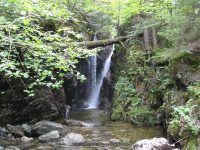
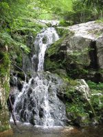
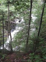
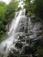
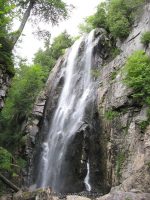
Artist Falls and Gill Brook Trail Waterfalls (St Huberts)
AKA: |
—– |
Location: |
Keene Twn |
First Visit: |
8/11/2011 |
Region: |
Northern |
County: |
Essex |
Park/Area: |
—– |
Gps of Falls: |
N44.12673 W73.80830 |
Gps of Parking: |
N44.14903 W73.77027 |
Gps of Trailhead: |
—– |
Trail Name/Reference to: |
—– |
Landmark: |
—– |
Stream/River/Watershed: |
Gill Brook |
Height of Falls/Type: |
10 ft, to 20 ft, Cascade |
Elevation: |
1811 ft |
Level of Difficulty/Hiking Distance: |
0.5 |
Wikiloc: |
—– |
Whitewater Rte/Canoe Rte Map: |
—– |
Maps: |
Eastern New York all outdoors Atlas & Field Guide Publication 2008 |
Trails Websites: |
—– |
My Resource: |
Eastern New York all outdoors Atlas & Field Guide Publication 2008 |
Book Resource: |
|
Brochures/Travel Guides/Visitor Guides: |
—– |
Additional Information: |
|
Photos And Information I Contributed To or Posted To Other Websites: |
—– |
Nearest Intersection: |
St Huberts Rd and Ausable Club Rd and Lake Rd |
Directions: |
From I-87 N in North Hudson, Take exit 30 to the right onto US-9 towards Rt-73/Keene Valley/Keene and drive for .2 miles. Turn left onto US 9 and drive for 2.2 miles. Keep left onto Hwy 73 N and drive for 5.4 miles. Turn left onto Ausable Rd and drive for .2 miles to the parking area. |
Comments/Notes: |
Waterfalls on the Gill Brook
#1 15 ft Block N44.12480 W73.80906
#2 Chute N44.12397 W73.80948
#4 15 ft Flume N44.12293 W73.80988
#5 9 ft Cascade N44.12247 W73.81003
#6 25 ft N44.12198 W73.81019
#7 Flume N44.12148 W73.81035
#8 Long Slide N44.12080 W73.81075
#9 10 ft N44.11999 W73.81125

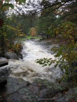
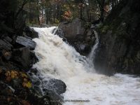
Ausable Chasm – 11 Named Waterfalls and Rapids
AKA: |
Adgate Falls, Birmingham Falls, Grand Canyon of the East |
Location: |
Chesterfield Twn/Au Sable Twn |
First Visit: |
8/17/2008 |
Region: |
Northern |
County: |
Clinton/Essex |
Park/Area: |
Ausable Chasm |
Gps of Falls: |
N44.52490 W73.46301 |
Gps of Parking: |
N44.52530 W73.46253 |
Gps of Trailhead: |
—– |
Trail Name/Reference to: |
—– |
Landmark: |
Tourist Attraction |
Stream/River/Watershed: |
Ausable River |
Height of Falls/Type: |
Various |
Elevation: |
300-150 ft |
Level of Difficulty/Hiking Distance: |
Inner Sanctum Trail (1 mile) Rim Walk Trail (2 miles) Dry Chasm Trail (1.5 miles) Rainbow Falls/Elephant’s Head Vista (1/2 mile) |
Wikiloc: |
—– |
Whitewater Rte/Canoe Rte Map: |
|
Maps: |
—– |
Trails Websites: |
—– |
My Resource: |
|
Book Resource: |
Adirondack Waterfall Guide “New York’s Cool Cascades” By Russell Dunn 2004 |
Brochures/Travel Guides/Visitor Guides: |
Adirondack Great Walks & Day Hikes A Guide to paths less taken in the Northeast’s last great wilderness |
Additional Information: |
Ausable Chasm Grand Canyon of the Adirondacks |
Photos And Information I Contributed To or Posted To Other Websites: |
Northern New York Waterfalls |
Nearest Intersection: |
Rte 9 and Old State Rd |
Directions: |
From I-87 N in Keeseville, Take exit 34 to the right onto Rt-9n towards Ausable Forks/Keeseville for .3 miles. Turn right onto Hwy 9n and drive for 1.3 miles. Turn left onto US 9 and drive for 1.5 miles. |
Comments/Notes: |
—– |
For additional information click on the following links
Dam And Falls
Rainbow Falls
Horseshoe Falls
Horseshoe Lower Falls
Diagonal Slide IV
Elephant Head Class III
Elephant Rock Rapid IV+
Long One IV Rapids
Mike’s Hole (lead-in) IV+ Rapids
Mike’s Hole Itself Class IV Rapids
The Pinch of the Chasm Class I
Exit Canal Class II+ Rapids

Jenny Creek Waterfalls on (7 Named Waterfalls)
Whitewater Route Jenny Creek
St Lawrence County, Town of Pitcairn
Date Visited: 10/7/2010
Stream or River: Gulf Stream/Jenny Creek
Resources Used:
World Waterfall Database
American Whitewater
Directions:
From I-81 N in Theresa, Take exit 49 to the right onto Rt-411 towards Theresa/Lafargeville for .3 miles. Turn right onto Highway 411 and drive for 4.7 miles. Turn left onto Commercial Street and drive for .7 miles. Turn left onto Oxbow Road and drive for 9.6 miles. Turn right onto Cr-25 and drive for 8.8 miles. Turn left onto W Main Street and drive for .3 miles. Turn right onto William Street and drive for 6.1 miles. Turn right onto Highway 812 and drive for 9.5 miles. Turn left onto Pitcairn-Fowler Road and drive for 1.3 miles. Turn left onto Highway 3 and drive for 1.3 miles. Bear right onto Jayville Road and drive for 1.0 miles. The first falls is Jenny Creek Falls Lower. I have not been to this one yet. Continue on Jayville Road for 1.0 miles. This next one is Jenny Creek Falls. Continue on Jayville Road and drive for .6 miles to Jenny Creek Middle Falls. Continue on Jayville Road and drive for .2 miles, this brings you to the last one, Jenny Creek Upper Falls.
Trail Description: Described within
Comments:
Putting together this whole section of Jenny Creek was and still is a bit confusing so I will piece it together as best as possible. When I checked this location out back in 2010, I had only 2 locations with the coordinates for. And those I had gotten from the World Waterfall database. Since then I have gain more knowledge along with better technology. I recently found that the American Whitewater has a page on this section of Jenny Creek. By matching my photos up with theirs along with similar descriptions, I have been able to make some corrections.
The whitewater route starts at Powell Road, south of Hwy 3. When I was there you could not drive on Jayville road all the way, as you come to where the bridge is out. So I did not check out their first 1.3 miles of the route.
1-Mike’s Boof Class III-Gulf Stream
2-Railroad Slide Class III+-Gulf Stream
Beaver Pond/Dam Class I-Gulf Stream
3-This one here I had called Jenny Creek Upper Falls (Footbridge rapid Class III+)
Described as starting under a footbridge and ending behind a camp. Viewing from this is roadside only, private property.
Another Beaver Pond/Dam Class I-Jenny Creek
4-Now this one I had called Jenny Creek Middle Falls, but it falls in the location they called the Ugly Drop-Jenny Creek
You will see a huge rock and smaller rock on top, looks like a huge cairn, on the side of the road. It is a short scramble but the view was hard to get.
5-Middle Section Class IV-Jenny Creek
6-And this one I had called Jenny Creek Lower Falls, and again it falls within the location and photo match with what they called Jayville Rapid Class 5.0/Jayville Slide. This may also be known as Jenny Creek Falls. This is a roadside view.
7-Horrific– which is described as being 30-35 foot drop.-Jenny Creek
8-The Rest Class III they describe one more dangerous section which maybe what resources are calling Jenny Creek Lower Falls.

Fallbrook Falls – 5 Waterfalls
AKA: |
The 5 Cascades |
Location: |
Annsville Twn |
First Visit: |
10/26/2008 |
Region: |
Central |
County: |
Oneida |
Park/Area: |
—– |
Gps of Falls: |
N43.34828 W75.58355 |
Gps of Parking: |
N43.35082 W75.58912 |
Gps of Trailhead: |
—– |
Trail Name/Reference to: |
—– |
Landmark: |
Fallbrook Stables |
Stream/River/Watershed: |
Fallbrook |
Height of Falls/Type: |
Various (5) Falls Total |
Elevation: |
900-843 ft |
Level of Difficulty/Hiking Distance: |
approx. 1 mile rt |
Wikiloc: |
—– |
Whitewater Rte/Canoe Rte Map: |
|
Maps: |
|
Trails Websites: |
—– |
My Resource: |
Friends |
Book Resource: |
—– |
Brochures/Travel Guides/Visitor Guides: |
—– |
Additional Information: |
|
Photos And Information I Contributed To or Posted To Other Websites: |
Northern New York Waterfalls, Digthefalls |
Nearest Intersection: |
Slater Rd And Coal Hill Rd |
Directions: |
From I-90 W, in Westmoreland, Take exit 32 to the right towards Rt-233/Westmoreland/Rome and drive for .7 miles. Turn right onto Cider Street and drive for .1 miles. Turn right onto Highway 233 and drive for 5.7 miles. Take the Rt-49 W/Rt-69 W/Rt-365 W ramp to the left and drive for .4 miles. Take the Rt-49 W/Rt-69 W ramp to the right towards Rt-26 N/Rt-46/Downtown Rome and drive for 1.3 miles. Keep left onto Erie Blvd E and drive for 10.5 miles. Turn right onto Main Street and drive for .7 miles. Turn right onto Coal Hill Road and drive for 3.6 miles. |
Comments/Notes: |
Park on the side of the road just a little north from the intersection of Slater Road and Coal Hill Road and then walk to the back of the field. Go right and follow the field edge down and into the second field. On your left watch for a well worn path. You will hear the river along the way. |
Fallbrook Falls #1, Annsville
Fallbrook Falls #2, Annsville
Fallbrook Falls #3, Annsville
Fallbrook Falls #4, Annsville
Fallbrook Falls #5, Annsville

Fillmore Glen State Park – 8 Named Waterfalls
Location: |
Locke Twn |
First Visit: |
6/19/2004 |
Region: |
Central |
County: |
Cayuga |
Park/Area: |
Fillmore Glen State Park |
Gps of Parking: |
N42.69714 W76.41545 |
Gps of Trailhead: |
N42.69714 W76.41545 |
Stream/River/Watershed: |
Dry Creek |
Height of Falls/Type: |
Various |
Level of Difficulty/Hiking Distance: |
4 Mile Loop, 2 Hours |
Maps: |
Western New York all outdoors Atlas & Field Guide Publication 2008 |
Trails Websites: |
|
My Resource: |
Western New York all outdoors Atlas & Field Guide Publication 2008 |
Book Resource: |
New York Waterfalls “A Guide For Hikers & Photographers” by Scott E. Brown 2010 |
Brochures/Travel Guides/Visitor Guides: |
Filmore Glen State Park |
Additional Information: |
|
Nearest Intersection: |
Hwy 38 and Hwy 38a and N Main St |
Directions: |
From I-81 South in Cortland, take exit 12 to the right onto US-11/Rt-41 towards Rt-281/Homer/Cortland and drive .4 miles. Keep left onto S West St ramp and drive .5 miles. Take the Rt-281 N ramp to the right towards Tr-90/Homer and drive .4 miles. Turn left onto Cayuga St and drive 10.4 miles. Turn right onto Toll Gate Rd and drive 3.8 miles. Turn right onto Hwy 38 and drive .3 miles. There will be signs along the way to help direct you to the park. |
Comments/Notes: |
Named waterfalls in the park: Cowshed Falls, Dalibarda Falls aka Lower Falls and Dry Falls, Hogsback Falls (Historical Name), Pinnacle Falls (Historical Name), Pinnacle Lower Falls, and Pinnacle Upper Falls |
For additional information please click on the following links:
Fillmore Glen – Cowshed Falls
Fillmore Glen – Cowsheds Upper Falls
Fillmore Glen – Pinnacle Falls (Historical Name)
Fillmore Glen – Dalibarda Falls
Fillmore Glen – Pinnacle Lower Falls
Fillmore Glen – Pinnacle Upper Falls
Fillmore Glen – Hogsback Falls (Historical Name)
Fillmore Glen – Upper Falls
A COUPLE OF BUSINESSES TO SHARE
ON OUR LAST ROAD-TRIP WE HAD THE PLEASURE OF FINDING ACCOMMODATIONS AT ROWE’S COTTAGES. VERY FRIENDLY AND CLEAN ROOMS. KEEP THEM IN MIND IF YOUR TRAVELING UP NEAR SCHROON LAKE. SAME OWNER TO THE STARRY NIGHT CABINS.
WE ALSO STOPPED INTO GOKEY’S TRADING POST. CHATTED WITH THE OWNER A BIT TRYING TO FIGURE OUT HOW HE WAS OR MAY HAVE BEEN RELATED TO A FRIEND OF MINE. THERE WAS EVERYTHING YOU CAN THIS OF IN MR GOKEY’S STORE. STOP IN AND CHECK IT OUT.

Road-trip September 27-28 2014 Whiteface Mountain
Well….it was one of those spontaneous decisions to head up north, to see the fall foliage! Destination-Whiteface Mountain….
Got a late start yesterday, getting on the road somewhere around 1:00-1:30pm with a 4 hour drive ahead of us. No plans, no pre-determined stops..just a throw and go….the throw and go, no planning I so much dislike…it was our first stop up at Inlet, that I realized I had grabbed the old camera, which works when it seems to want too….so I suffered with trying to utilize the cell phone. Now mind you….I have not really practiced taking pics for any real purpose with the Iphone.
We managed to hit a couple of new waterfall locations for me. We also re-visited some old ones. Drove by several ones I wanted to hit, but had to remind myself our destination was Whiteface. The new ones were Squaw Brook Falls and Clifford Falls. The re-visited ones were Schroon Falls and Split Rock Falls and the falls on route 73, which I still yet need to verify exact information on. I also took a few more pics of the waterfall you see going up the Whiteface Memorial Highway.
Now, I would like to take a moment and go back to Schroon Falls. We again asked some folks in Schroon Lake if they knew of the whereabouts of Schroon Falls. I have information that there is 2 different locations with different height and distance. I still cannot located the second one.
I am currently behind on getting photos posted here to website. Will try my best to at least get the new ones up.
I just wanted to also share that this trip, was my grandson (6 years old) first actual big climb. This was the trail at the top of Whiteface Mountain. My grandson did awesome with the length of travel time as well. I am so proud of him. Also cannot forget to mention my little Lilabelle (Chihuahua) also made the great climb! I had my hands full, dog in one, grandchild in the other not to mention, water bottle and cell phone and old camera!

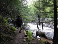
St Huberts, Essex County, Northern, New York 8-11-2011 Hike
I am going to do by best here with piecing together the hike in the St Huberts area. This is written up for a few friends that was inquiring on the New York Waterfalls group
We arrived at the trailhead visitor parking area at about 8am. You first have to park in designated area, and then walk down the Ausable Club road to the trail beginning.
We started off by taking the West River Trail. We were going to go to Russell Brook Falls first, but was told at the gate that it was on private property.
We arrived at Pyramid Falls at about 9:50am
The next set of photos were taken before we got to Wedgebrook Falls
We arrived at Wedgebrook Falls at about 11:01am
The next set of photos were taken before reaching Beaver Meadow Falls
We arrived at Beaver Meadow Falls at about 11:30am
Our next stop we came to Rainbow Falls. We arrived here at about 12:36pm
From here we were headed for Fairy Ladder Falls, or so we thought! We crossed over to the East side and headed towards what we thought the trail to Fairy Ladder. Instead we ended up at Fish Hawk Cliffs. We arrived here at about 2:16pm
It was at this point we had to make a decision. We seen no signs pointing the way to Fairy Ladder. What we did not know at the time, was that instead of taking the trail to Fish Hawk Cliff, we should have continued straight on the trail that connects to the Gill Brook Trail and should have gone right. But we did not know this.
We climb back down and got onto the Gill Brook Trail and decided we had to head back out before dark. We got to the Gill Brook trail at about 2:47pm, we were headed for Lake Road. I am glad we did not trackback to get to Lake road or we would have not seen the falls along the Gill Brook including Artists Falls
I believe Artist Falls was one of the first few photos shown here..
We got to the gate at about 4:58 pm and headed back to the car.
I hope this will help others that are planning on this hike and are new to the area as we were. Word of advice…do not try this hike when you are sick!!! Holy Cow…we did not sleep well the night before, coughing and feverish and tired before even starting….I was determined to take the hike anyways…brutal!!!