Road Trip to Rensselaer County, New York area 2/22/2014 Day 1
Road Trip to Rensselaer County, New York area 2/22/2014 Day 1
For this road trip, I had 24 planned stops. Of those 24, we seen 17, accidentally driving by 2, and we cut off 5 others due to time. This was about a 427 mile round trip in which I calculated about 10 hours. This did not include the time for stopping or hiking.
Clicking on the links will take you to the page with more photos and information.
Day 1
Washout Creek (Falls on) Schenectady County Eastern New York
As shown in the photos, I took a few snap shots to where we ended on the trail. We met a gentleman on snowshoes and asked him how much farther to the falls and he was telling us it was or would be very difficult to get down to the falls in the snow. And in answer to the question, we still had a bit further to go on the trail. At that point, the man said that Plotter Kill Falls was the place to go and that the falls were running the week prior. So we turned around and headed back out. I plan to return to this location in the near future.
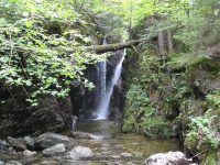
Plotter kill Falls Schenectady County Eastern New York
We really did not know what we were getting into here, as I did not really do my research for this location, as it was not planned. First thing when we arrived we looked at the trail map to determine which direction to start. To make it short, we choose the rim trail. The falls we did see from top did not appear to be running, but we did not get down into the gorge either. We walked the whole length of the trail above and I took the best photos I could. We did meet up with another group that had walked the other side. In fact I did have some photos with them looking like little dots across the way. This is one location I plan to return to in the future.
Krystal Falls Schenectady County Eastern New York
The view of the falls from the road in which resources indicated to take did not give a clear view of the falls. We drove over to the restaurant/bar, “Pig N Whistles” their was quite the crowd of people and so we did not go in and get permission to access the falls. There was a fence up around the whole back and view of falls was not accessible. Also with all the snow it did not appear anyone was walking back there. Plans to return in the future.
Krystal Upper Falls Schenectady County Eastern New York
As we pulled out of the parking from the restaurant, I spotted this directly across the road and named it Upper Falls.
Lock 7 Dam and Falls Schenectady County Eastern New York
Located at the VISCHER FERRY HYDRO ELECTRIC PLANT. The gate was closed, however there is a small parking area at the top. The sign states a public fishing access. We walked around the gate and went down to the bottom. There were other folks there as well.
Buttermilk Falls (Schagticoke) Rensselaer County Eastern New York
This is a roadside waterfalls. Downstream is another waterfall, which is on private property. I tried taking a couple of photos, which would be views of the top of that waterfall.
Hidden Falls Rensselaer County Eastern New York
This is located on private property. Should I get to the location again, I plan on seeing if I can obtain permission for access.
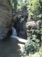
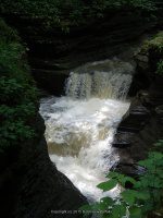
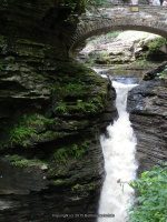
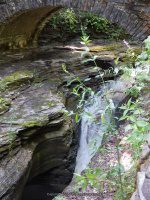
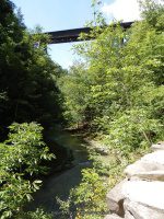
Great Falls of the Hoosic Rensselaer County Eastern New York
This is one of my corrected errors. Right location and information, had the wrong name. I had wrongly listed this as Hoosic Falls. This is also known as Great Falls. This one has the big dam on the one side of the bridge.
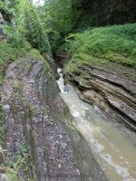
Valley Falls Rensselaer County Eastern New York
This is also know as Schagticoke Falls. I believe I found this but there was no real photo opportunity as of ice and snow it did not look like much of anything. This is listed as being rapids.
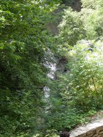
Factory Hollow Falls Rensselaer County Eastern New York
This is listed as having small drop of about 4 feet.
Goulds Creek (Falls on) South Oakwood Cemetery Rensselaer County Eastern New York
This is also known as Goulds Creek Lower Falls and Devil’s Kitchen Falls. By the time we got here and found it we were working with very little daylight. Plans to return to this location in the future.
Goulds Creek (Falls on) North Oakwood Cemetery Rensselaer County Eastern New York
We bypassed this for another time.
Day 2 to follow
| Original content here is published under these license terms: | X |
|
| License Type: | General Public License | |
|
| License Abstract: | The GNU General Public License is a free, copyleft license for software and other kinds of works. You may re-publish the content (modified or unmodified) providing the re-publication is itself under the terms of the GPL. |
|
| License URL: | http://www.gnu.org/licenses/gpl.html |
Like this:
Like Loading...


 Rensselaer County Eastern New York 2-22-2014_00006.JPG")