Watkins Glen State Park and Waterfalls
Watkins Glen State Park and Waterfalls
Watkins Glen State Park and Waterfalls Schuyler County, Watkins Glen, New York
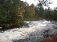
Stream or River: Glen Creek flows into Seneca Lake
Elevation: 1010 ft to 490 ft
Dates Visited:
6/13/1991 8/21/2004 8/10/2013
Maps and Resources used to gather information:
Western New York all outdoors Atlas & Field Guide Publication 2008 102 B3
Watkins Glen Trail Map
200 Waterfalls In Central And Western New York By Rich And Sue Freeman
Finger Lakes Tourism Alliance website
World Waterfall Database
Nyfalls
Falzguy
Directions:
From I-90 W , Take exit 42 to the right onto Rt-14 towards Geneva/Lyons and drive for .7 miles. Take the Rt-14 S ramp to the right towards Rt-96/Geneva/Clifton Springs and drive for 5.8 miles. Turn right onto Castle Street and drive for .2 miles. Turn left onto Main Street and drive for 35.8 miles.
Length of Hike: 3 Miles Round Trip
Indian Trail 1.5 miles one way
South Rim Trail 4.5 miles one way
Gorge Trail 1.5 miles one way
Parking areas:
Parking N42.37550 W76.87305
Parking #2 N42.37427 W76.89228
South Parking N42.36961 W76.87263
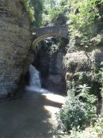
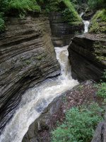
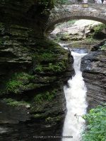
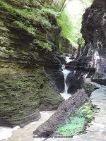
Entrance Cascade Falls
Hike: approx. .2 to .3 miles
Falls: N42.37504 W76.87350
Landmark: Under the Sentry Bridge
Height: 41 ft
Elevation: 534 ft
Type: Cascade
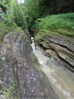
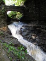
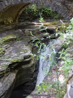
Still Water Gorge
Falls: N42.37469 W76.87398
Landmark: The View Upstream From The Sentry Bridge
Height:
Elevation: 602 ft
Type: Chutes/Flumes/Pools

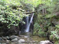
Minnehaha Falls aka Curtain Cascade Falls
Falls: N42.37451 W76.87488
Landmark: Flows into the heart shaped pool.
Height: 21 ft
Elevation: 657 ft
Type: Cascade
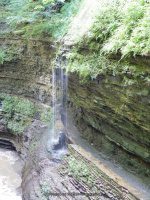
Cavern Cascade Falls
Hike: approx. .3 to .4 mile
Falls: N42.37447 W76.87557
Landmark: Walk Behind Falls And Into Spiral Tunnel
Height: 50 ft
Elevation: 677 ft
Type: Cascade/Flume

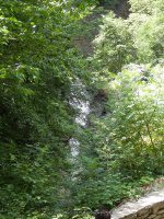
Whispering Falls
Falls: N42.37437 W76.87756
Landmark: Located in the section called the Narrows
Height:
Elevation: 734 ft
Type:
Diamond Falls
Hike: approx. .4 to .5 mile
Falls: N42.37432 W76.87786
Landmark: Located in the section called the Narrows.
Height: 12 ft
Elevation: 744 ft
Type:
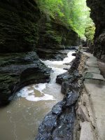
The Narrows
Falls: N42.37410 W76.87842
Landmark: Lovers Lane
Height:
Elevation: 750 ft
Type: Chutes/Flumes/Pools
Glen Cathedral
Falls: N42.37385 W76.87929
Landmark: Folly Bridge Sylvan Rapids is in this area.
Height:
Elevation: 813 ft
Type: Chutes/Flumes/Pools

Sylvan Rapids
Falls: N42.37400 W76.87884
Landmark: This Is In The Section Known As Glen Cathedral
Height:
Elevation: 796 ft
Type: Rapids
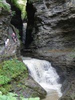
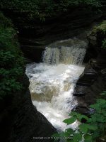
Central Cascade Falls
Hike: approx. .6 mile
Falls: N42.37358 W76.88069
Landmark: Pass Thru Tunnel And Walk To Bridge Over It
Height: 60 ft
Elevation: 817 ft
Type: Plunge Cascade
Glen Of Pool Falls
Falls: N42.37344 W76.88140
Landmark: The Glen Of Pools Leads To Rainbow Falls.
Height:
Elevation: 827 ft
Type: Chutes/Flumes/Pools

Triple Cascade Falls
Falls: N42.37272 W76.88258
Landmark:
Height: 26 ft
Elevation: 858 ft
Type: Cascade
Rainbow Falls
Falls: N42.37275 W76.88254
Landmark: You Will Walk Under This Waterfall, stop long enough for a quick cool off!
Height: 95 ft
Elevation: 860 ft
Type:
Pluto Falls
Falls: N42.37231 W76.88484
Landmark: Located In The Section Of Spiral Gorge (Frowning Cliff)
Height: 9 ft
Elevation: 914 ft
Type:

Glen Omega Falls
Falls: N42.37218 W76.88519
Landmark:
Height:
Elevation: 925 ft
Type:
Pool Of Nymphs
Falls: N42.37211 W76.88540
Landmark: This Is In The Section Known As Glen Arcadia: Pluto Falls Glen Omega Falls
Height:
Elevation: 927 ft
Type: Chutes/Flumes/Pools
Mile Point Falls aka Arcadia Falls
Falls: N42.37186 W76.88641
Landmark: This marks the 1 mile mark of your hike. This is a stone bridge over this. You can walk over this and take the south rim trail back down or continue on up another half mile and take the shuttle back down.
Height: 12 ft
Elevation: 921 ft
Type: Cascade
Fairies Pool Falls
Falls:
Landmark:
Height:
Elevation: 950 ft
Type: Chutes/Flumes/Pools

Jacobs Ladder
Falls: N42.37139 W76.89098
Landmark: This Is The Section At The Top Of The Gorge Where The Rail Bridge Is
Height:
Elevation: 960 ft
Type: Chutes/Flumes


 Rensselaer County Eastern New York 2-22-2014_00006.JPG")